Lichtenvoorde
Town in Gelderland, Netherlands From Wikipedia, the free encyclopedia

Lichtenvoorde is a town in the east of the Netherlands, in the municipality of Oost Gelre.
Lichtenvoorde | |
|---|---|
Town | |
Protestant St John church | |
 Flag  Coat of arms | |
 Lichtenvoorde Location in the province of Gelderland in the Netherlands  Lichtenvoorde Lichtenvoorde (Netherlands) | |
| Coordinates: 51°59′17″N 6°34′11″E | |
| Country | Netherlands |
| Province | Gelderland |
| Municipality | Oost Gelre |
| Area | |
• Total | 11.49 km2 (4.44 sq mi) |
| Elevation | 21 m (69 ft) |
| Population (2021)[1] | |
• Total | 12,910 |
| • Density | 1,100/km2 (2,900/sq mi) |
| Time zone | UTC+1 (CET) |
| • Summer (DST) | UTC+2 (CEST) |
| Postal code | 7131 & 7132[1] |
| Dialing code | 0544 |
Lichtenvoorde holds a flower parade (bloemencorso) every September at the start of its annual festival. The parade features floats covered in flowers (usually dahlias) in imaginative designs depicting a variety of themes.
Lichtenvoorde has a motocross circuit on which international grands prix are held.
History
Lichtenvoorde was the name of a municipality that included the town and the villages of Lievelde, Zieuwent, Vragender and Harreveld, until 1 January 2005, when all were merged into the municipality of Oost Gelre.
Its inhabitants are known colloquially as keienslöppers (boulder draggers) due to a historic event. On 15 March 1874, 99 of the town's shoemakers dragged a 20 ton boulder a distance of around four kilometres to the marketplace to serve as a centerpiece for commemoration of King William III's silver jubilee, after 25 years on the country's throne. The boulder remains there to this day, topped by a stone lion holding the town's coat of arms.
Gallery
 The boulder in the marketplace
 Catholic church in Lichtenvoorde
 Farm at the open-air museum Erve Kots in Lievelde
 Catholic church in Zieuwent
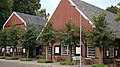 Vragender Village
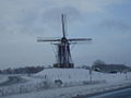 Windmill Hermien in Harreveld


References
External links
Wikiwand - on
Seamless Wikipedia browsing. On steroids.