Hinduism in Punjab, Pakistan
Overview of the role and impact of Hinduism in the Pakistani province of Punjab From Wikipedia, the free encyclopedia

Hinduism is a minority religion in Punjab province of Pakistan followed by about 0.19% of its population. Punjab has the second largest number of Hindus in Pakistan after Sindh.[3] Hinduism is followed mainly in the Southern Punjab districts of Rahim Yar Khan and Bahawalpur.[4]
Hindus in Cholistan celebrating Holi | |
| Total population | |
|---|---|
| 249,716 (2023)[1] 0.20% of total Province population | |
| Religions | |
| Hinduism (majority) Nanakpanthi and Kalash | |
| Scriptures | |
| Bhagavad Gita, and Vedas Guru Granth Sahib (only by Nanakpanthi) | |
| Languages | |
| Sanskrit (sacred) Punjabi, Marwari, Saraiki[2] Hindi, Urdu and other languages (minority) |
Hinduism has a strong historical presence in Punjab with many mandirs, shrines (samadhis), alongside various religious traditions and texts that were developed in the region. According to the 1941 census, Punjabi Hindus constituted approximately 13.7 percent of the population in the region that comprises the contemporary state of Punjab, Pakistan.[a] With violence and religious cleansing accompanying the partition of India in 1947, the vast majority departed the region en masse, primarily migrating eastward to Delhi and the region of Punjab that would fall on the eastern side of the Radcliffe Line, in the contemporary Indian states of Punjab, Haryana, and Himachal Pradesh.
History
Summarize
Perspective

| Year | Pop. | ±% p.a. |
|---|---|---|
| 1881 | 1,449,913 | — |
| 1901 | 1,944,363 | +1.48% |
| 1911 | 1,645,758 | −1.65% |
| 1921 | 1,797,141 | +0.88% |
| 1931 | 1,957,878 | +0.86% |
| 1941 | 2,373,466 | +1.94% |
| 1951 | 33,052 | −34.78% |
| 1998 | 116,410 | +2.72% |
| 2017 | 211,641 | +3.20% |
| 2023 | 249,716 | +2.80% |
| Source: [b][c][d][e][f][a][14][15][16][17][1] Census of India, Census of Pakistan | ||
Ancient era
Hinduism is the oldest recorded religion practiced by the Punjabi people.[18] The Rig Veda, the oldest and most sacred Hindu text, is believed to have been composed in the Punjab region of modern-day Pakistan (and India) on the banks of the Indus River around 1500 BCE.[19] The Punjab region also features heavily in the Mahabharata.[20][21] According to Hindu religious texts, Multan was founded by the Hindu sage Kashyapa[22] and also asserts Multan as the capital of the Trigarta Kingdom ruled by the Katoch dynasty at the time of the Kurukshetra War that is central the Hindu epic poem, the Mahabharata.[23][24][25] Historically, the Punjabi Hindus and Saraiki Hindus followed mainly a Brahminical form of Hinduism.[26] The Prahladpuri Temple in Multan is believed to be constructed by Prahlada in honor of Narasimha.[27] Most of the Hindus in Punjab once also had also influence of Sikhism on their culture and lifestyle. Nanakpanthis are the Hindus who follows the teaching of Sikh guru, Guru Nanak.[28]
Colonial era
By the early 20th century, Western Punjab (present-day Punjab, Pakistan) had a Punjabi Muslim majority population (primarily supporting the Muslim League and Pakistan Movement) but also included significant Punjabi Hindu and Punjabi Sikh minority populations.
According to the 1941 census, Punjabi Hindus constituted approximately 13.7 percent of the population in the region that comprises the contemporary state of Punjab, Pakistan, numbering around 2.4 million persons.[a] Following the partition of Punjab, according to the 1951 census, the Hindu population declined to 33,052 persons or 0.2 percent due to religious cleansing violence alongside large-scale mass migration and population transfer to East Punjab, India and Delhi in the violent events of partition of India.[14]
With the formation of independent Pakistan and India during the partition of India in 1947, approximately 3 million Punjabi Hindus migrated to India.[29][30][31]
Geographical distribution
Summarize
Perspective
,_RP-F-2001-7-1122D-51.jpg)


_A_Hindu_temple,_possibly_Shaivite_in_1914.jpg)
Colonial era
| District or Princely State | 1881[5][6][7][32] | 1901[8]: 34 [33]: 62 | 1911[9]: 27 [10]: 27 | 1921[11]: 29 | 1931[12]: 277 | 1941[13]: 42 | ||||||
|---|---|---|---|---|---|---|---|---|---|---|---|---|
| Pop. | % | Pop. | % | Pop. | % | Pop. | % | Pop. | % | Pop. | % | |
| Sialkot District | 299,311 | 29.57% | 302,012 | 27.86% | 242,325 | 24.74% | 217,912 | 23.24% | 206,421 | 21.07% | 231,319 | 19.43% |
| Lahore District | 193,319 | 20.92% | 276,375 | 23.78% | 217,609 | 21% | 255,690 | 22.6% | 259,725 | 18.84% | 284,689 | 16.79% |
| Gujranwala District | 127,322 | 20.64% | 169,594 | 22.41% | 176,075 | 19.07% | 101,566 | 16.29% | 92,764 | 12.6% | 108,115 | 11.85% |
| Multan District | 112,001 | 20.29% | 133,560 | 18.79% | 126,603 | 15.54% | 134,013 | 15.05% | 182,029 | 15.49% | 249,872 | 16.83% |
| Shakargarh Tehsil[g] | 109,241 | 49.77% | 111,819 | 47.69% | 93,052 | 44.22% | 90,645 | 42.59% | 101,318 | 40.96% | 116,553 | 39.98% |
| Bahawalpur State | 91,272 | 15.92% | 114,670 | 15.91% | 109,548 | 14.03% | 114,621 | 14.67% | 149,454 | 15.18% | 174,408 | 13% |
| Rawalpindi District | 86,162 | 10.5% | 86,269 | 9.27% | 48,449 | 8.84% | 57,185 | 10.05% | 59,485 | 9.38% | 82,478 | 10.5% |
| Montgomery District | 83,974 | 19.69% | 109,945 | 23.72% | 66,803 | 12.48% | 94,791 | 13.28% | 136,783 | 13.68% | 210,966 | 15.87% |
| Gujrat District | 72,450 | 10.51% | 69,346 | 9.24% | 49,430 | 6.63% | 62,529 | 7.59% | 73,356 | 7.95% | 84,643 | 7.66% |
| Jhang District | 64,892 | 16.42% | 79,650 | 21.03% | 73,426 | 14.24% | 85,339 | 14.96% | 102,990 | 15.49% | 129,889 | 15.81% |
| Jhelum District | 60,949 | 10.34% | 51,801 | 8.72% | 34,261 | 6.7% | 34,837 | 7.3% | 36,068 | 6.67% | 40,888 | 6.49% |
| Shahpur District | 59,026 | 14% | 68,489 | 13.06% | 72,695 | 10.58% | 82,182 | 11.42% | 90,561 | 11.02% | 102,172 | 10.23% |
| Dera Ghazi Khan District | 46,697 | 12.85% | 57,815 | 12.27% | 56,485 | 11.3% | 56,346 | 12.01% | 57,217 | 11.65% | 67,407 | 11.59% |
| Muzaffargarh District | 43,297 | 12.79% | 52,221 | 12.87% | 68,158 | 11.97% | 69,878 | 12.29% | 72,577 | 12.27% | 90,643 | 12.72% |
| Lyallpur District[h] | — | — | 210,459 | 26.58% | 154,603 | 18.03% | 181,488 | 18.53% | 173,344 | 15.06% | 204,059 | 14.61% |
| Mianwali District | — | — | 50,202 | 11.82% | 36,326 | 10.64% | 45,974 | 12.83% | 49,794 | 12.1% | 62,814 | 12.41% |
| Biloch Trans–Frontier Tract | — | — | 136 | 0.56% | 169 | 0.59% | 180 | 0.67% | 173 | 0.58% | 160 | 0.4% |
| Attock District[i] | — | — | — | — | 19,741 | 3.8% | 26,184 | 5.11% | 31,932 | 5.47% | 43,209 | 6.39% |
| Sheikhupura District[j] | — | — | — | — | — | — | 85,781 | 16.4% | 81,887 | 11.75% | 89,182 | 10.46% |
| Total Hindus | 1,449,913 | 18.26% | 1,944,363 | 18.65% | 1,645,758 | 14.82% | 1,797,141 | 15.12% | 1,957,878 | 13.94% | 2,373,466 | 13.68% |
| Total Population | 7,942,399 | 100% | 10,427,765 | 100% | 11,104,585 | 100% | 11,888,985 | 100% | 14,040,798 | 100% | 17,350,103 | 100% |
Modern era
According to the 2023 Cenus, Hinduism is followed by 0.2 percent of the population, [34] which is roughly the same proportion as reported in the 2017 Census.[3] There are 249,716 Hindus in Punjab.[34] However according to the Pakistan Hindu Council, there are 349,230 Hindus in Punjab. [35]
According to estimates in religious minorities in Pakistan's elections, there are above 50,000 or more in 11 districts in Pakistan. All of these are in Sindh except the Rahim Yar Khan District in Punjab and is the only district in Punjab with more than 2% of its population as Hindu.[36]
About 90% of the Hindus in Punjab province live in Rahim Yar Khan and Bahawalpur.[37]
| District | 1951[14] | 2017[16][17] | 2023[1] | |||
|---|---|---|---|---|---|---|
| Pop. | % | Pop. | % | Pop. | % | |
| Sialkot District | 14,397 | 0.98% | 2,870 | 0.07% | 3,195 | 0.07% |
| Rahim Yar Khan District | 10,755 | 1.26% | 150,093 | 3.12% | 176,416 | 3.17% |
| Lahore District | 2,433 | 0.13% | 2,670 | 0.02% | 2,811 | 0.02% |
| Bahawalpur District | 1,916 | 0.2% | 41,051 | 1.12% | 48,684 | 1.14% |
| Gujranwala District | 1,211 | 0.12% | 287 | 0.01% | 1,033 | 0.02% |
| Faisalabad District | 888 | 0.04% | 598 | 0.01% | 2,150 | 0.02% |
| Sheikhupura District | 461 | 0.05% | 323 | 0.01% | 820 | 0.02% |
| Attock District | 308 | 0.04% | 575 | 0.03% | 501 | 0.02% |
| Multan District | 151 | 0.01% | 2,366 | 0.05% | 1,709 | 0.03% |
| Rawalpindi District | 114 | 0.01% | 1,244 | 0.02% | 1,013 | 0.02% |
| Gujrat District | 99 | 0.01% | 120 | 0% | 217 | 0.01% |
| Sahiwal District | 90 | 0% | 297 | 0.01% | 217 | 0.01% |
| Jhelum District | 72 | 0.01% | 356 | 0.03% | 343 | 0.03% |
| Jhang District | 69 | 0.01% | 195 | 0.01% | 73 | 0% |
| Sargodha District | 58 | 0% | 141 | 0% | 456 | 0.01% |
| Muzaffargarh District | 24 | 0% | 733 | 0.02% | 716 | 0.01% |
| Dera Ghazi Khan District | 6 | 0% | 248 | 0.01% | 166 | 0% |
| Mianwali District | 0 | 0% | 21 | 0% | 63 | 0% |
| Bahawalnagar District | — | — | 2,631 | 0.09% | 3,106 | 0.09% |
| Rajanpur District | — | — | 1,442 | 0.07% | 1,030 | 0.04% |
| Narowal District | — | — | 657 | 0.04% | 833 | 0.04% |
| Layyah District | — | — | 553 | 0.03% | 252 | 0.01% |
| Mandi Bahauddin District | — | — | 357 | 0.02% | 326 | 0.02% |
| Khanewal District | — | — | 297 | 0.01% | 304 | 0.01% |
| Nankana Sahib District | — | — | 245 | 0.02% | 1,196 | 0.07% |
| Kasur District | — | — | 243 | 0.01% | 475 | 0.01% |
| Okara District | — | — | 214 | 0.01% | 214 | 0.01% |
| Chakwal District | — | — | 187 | 0.01% | 142 | 0.01% |
| Vehari District | — | — | 179 | 0.01% | 226 | 0.01% |
| Toba Tek Singh District | — | — | 123 | 0.01% | 279 | 0.01% |
| Pakpattan District | — | — | 97 | 0.01% | 61 | 0% |
| Lodhran District | — | — | 93 | 0.01% | 97 | 0.01% |
| Chiniot District | — | — | 62 | 0% | 132 | 0.01% |
| Hafizabad District | — | — | 48 | 0% | 380 | 0.03% |
| Bhakkar District | — | — | 13 | 0% | 25 | 0% |
| Khushab District | — | — | 12 | 0% | 55 | 0% |
| Total Hindus | 33,052 | 0.16% | 211,641 | 0.19% | 249,716 | 0.2% |
| Total responses | 20,636,702 | 100% | 109,989,655 | 100% | 127,333,305 | 99.72% |
| Total population | 20,636,702 | 100% | 109,989,655 | 100% | 127,688,922 | 100% |
Community life
Hindus in Punjab is mainly concentrated in the Southern Punjab districts. According to a study, the majority (86.5%) of the scheduled caste Hindus in Southern Punjab have experienced discrimination. The study found that majority (i.e 91.5%) of the respondents in Rahimyar Khan districts believed that political parties are not giving importance to them.[38] In Central Punjab, the population of Hindus are very low, so many of the Hindus have married Sikhs and vice versa. Intermarriages between the Hindus and Sikh community are very common there.[39] The Forced conversion of Hindu girls are a problem faced by the Hindu community. According to a report by Minority Rights Commission, the number of forced conversions and forced marriages increasing in South Punjab, particularly the Rahim Yar Khan District and adjacent areas.[40]
Hindu marriages in Punjab are registered under the Hindu marriage act of 2017.[41][42]
Politics
Punjab Assembly has eight reserved seats for non-Muslims and most of them are Christians.[36] In 1997, the Seth Bharta Ram became the first Hindu to be elected to the minority reserved seat in Punjab Provincial assembly. It was only after 16 years, another Hindu member Kanji Ram was elected to the provincial assembly.[43][44] Currently there are no Hindu member in the 17th Punjab provincial assembly.
Hindus form a significant electoral role in the assembly seats of Rahim Yar Khan District.[36]
Temples


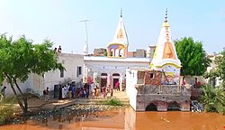 Baba Ram Thaman Shrine, a multi-religious shrine.


There are many temples in the Punjab and mainly of them served as a worship place for multi-religious community. The notable of them includes:
See also
Notes
- 1941 figure taken from census data by combining the total population of all districts (Lahore, Sialkot, Gujranwala, Sheikhupura, Gujrat, Shahpur, Jhelum, Rawalpindi, Attock, Mianwali, Montgomery, Lyallpur, Jhang, Multan, Muzaffargargh, Dera Ghazi Khan), one tehsil (Shakargarh – then part of Gurdaspur District), one princely state (Bahawalpur), and one tract (Biloch Trans–Frontier) in Punjab Province, British India that ultimately fell on the western side of the Radcliffe Line. See 1941 census data here: [13]: 42
Immediately following the partition of India in 1947, these districts and tract would ultimately make up the subdivision of West Punjab, which also later included Bahawalpur. The state that makes up this region in the contemporary era is Punjab, Pakistan. - 1881 figure taken from census data by combining the total population of all districts (Lahore, Sialkot, Gujranwala, Gujrat, Shahpur, Jhelum, Rawalpindi, Montgomery, Jhang, Multan, Muzaffargargh, Dera Ghazi Khan), one tehsil (Shakargarh – then part of Gurdaspur District), and one princely state (Bahawalpur) in Punjab Province, British India that ultimately fell on the western side of the Radcliffe Line. See 1881 census data here: [5][6][7]
Immediately following the partition of India in 1947, these districts and tract would ultimately make up the subdivision of West Punjab, which also later included Bahawalpur. The state that makes up this region in the contemporary era is Punjab, Pakistan. - 1901 figure taken from census data by combining the total population of all districts (Lahore, Sialkot, Gujranwala, Gujrat, Shahpur, Jhelum, Rawalpindi, Mianwali, Montgomery, Lyallpur (inscribed as the Chenab Colony on the 1901 census), Jhang, Multan, Muzaffargargh, Dera Ghazi Khan), one tehsil (Shakargarh – then part of Gurdaspur District), one princely state (Bahawalpur), and one tract (Biloch Trans–Frontier) in Punjab Province, British India that ultimately fell on the western side of the Radcliffe Line. See 1901 census data here: [8]: 34
Immediately following the partition of India in 1947, these districts and tract would ultimately make up the subdivision of West Punjab, which also later included Bahawalpur. The state that makes up this region in the contemporary era is Punjab, Pakistan. - 1911 figure taken from census data by combining the total population of all districts (Lahore, Sialkot, Gujranwala, Gujrat, Shahpur, Jhelum, Rawalpindi, Attock, Mianwali, Montgomery, Lyallpur, Jhang, Multan, Muzaffargargh, Dera Ghazi Khan), one tehsil (Shakargarh – then part of Gurdaspur District), one princely state (Bahawalpur), and one tract (Biloch Trans–Frontier) in Punjab Province, British India that ultimately fell on the western side of the Radcliffe Line. See 1911 census data here: [9]: 27 [10]: 27
Immediately following the partition of India in 1947, these districts and tract would ultimately make up the subdivision of West Punjab, which also later included Bahawalpur. The state that makes up this region in the contemporary era is Punjab, Pakistan. - 1921 figure taken from census data by combining the total population of all districts (Lahore, Sialkot, Gujranwala, Sheikhupura, Gujrat, Shahpur, Jhelum, Rawalpindi, Attock, Mianwali, Montgomery, Lyallpur, Jhang, Multan, Muzaffargargh, Dera Ghazi Khan), one tehsil (Shakargarh – then part of Gurdaspur District), one princely state (Bahawalpur), and one tract (Biloch Trans–Frontier) in Punjab Province, British India that ultimately fell on the western side of the Radcliffe Line. See 1921 census data here: [11]: 29
Immediately following the partition of India in 1947, these districts and tract would ultimately make up the subdivision of West Punjab, which also later included Bahawalpur. The state that makes up this region in the contemporary era is Punjab, Pakistan. - 1931 figure taken from census data by combining the total population of all districts (Lahore, Sialkot, Gujranwala, Sheikhupura, Gujrat, Shahpur, Jhelum, Rawalpindi, Attock, Mianwali, Montgomery, Lyallpur, Jhang, Multan, Muzaffargargh, Dera Ghazi Khan), one tehsil (Shakargarh – then part of Gurdaspur District), one princely state (Bahawalpur), and one tract (Biloch Trans–Frontier) in Punjab Province, British India that ultimately fell on the western side of the Radcliffe Line. See 1931 census data here: [12]: 277
Immediately following the partition of India in 1947, these districts and tract would ultimately make up the subdivision of West Punjab, which also later included Bahawalpur. The state that makes up this region in the contemporary era is Punjab, Pakistan. - Part of Gurdaspur District which was awarded to Pakistan as part of the Radcliffe Line.
- District formerly inscribed as the Chenab Colony on the 1901 census, later renamed to Lyallpur District, created between Jhang District, Gujranwala District, Lahore District, Montgomery District, and Multan District to account for the large population increase in the region, primarily due to the Chenab Canal Colony.
- District created in 1904 by taking Talagang Tehsil from Jhelum District and Pindi Gheb, Fateh Jang and Attock Tehsils from Rawalpindi District.
- District created between Gujranwala District, Sialkot District, Amritsar District, Lahore District, Montgomery District, and Lyallpur District in 1920 to account for the large population increase in the region, primarily due to the Chenab Canal Colony.
References
External links
Wikiwand - on
Seamless Wikipedia browsing. On steroids.