Gosainganj, Lucknow
Town in Uttar Pradesh, India From Wikipedia, the free encyclopedia
Town in Uttar Pradesh, India From Wikipedia, the free encyclopedia
Gosainganj, also spelled Goshainganj or Gosaiganj is a town and nagar panchayat in Lucknow district of Uttar Pradesh, India.[1] It is the seat of a community development block, which is included in the tehsil of Mohanlalganj.[1] As of 2011, its population is 9,649, in 1,685 households.[1] The starting point of the Purvanchal Expressway i.e. Chand Saray village is situated 2.5 km away from Gosainganj.
Gosainganj | |
|---|---|
Town | |
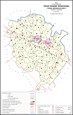
 Map of Gosainganj CD block | |
| Coordinates: 26.77°N 81.12°E | |
| Country | |
| State | Uttar Pradesh |
| District | Lucknow |
| Government | |
| • Mayor | Nikhil Mishra |
| Area | |
• Total | 5.9 km2 (2.3 sq mi) |
| Elevation | 113 m (371 ft) |
| Population (2011) | |
• Total | 9,649 |
| • Density | 1,600/km2 (4,200/sq mi) |
| Languages | |
| • Official | Hindi |
| Time zone | UTC+5:30 (IST) |
| Vehicle registration | UP-32 |
Gosainganj is located at 26.77°N 81.12°E.[2] It has an average elevation of 113 meters (374 feet). Gosaiganj is located 20 km from Lucknow city on Lucknow to Sultanpur Highway (NH-56) and about 22 km from Lucknow Charbagh Railway Station.
Gosainganj dates back to the Nawabi period in the 18th century, during the reign of Shuja-ud-Daula.[3] At that time, the Nawabi cavalry commander Raja Himmat Singh Goshain received the pargana of Amethi as a jagir, and he built a fort and market here, on the site of an abandoned Bhar village.[3] After Shuja-ud-Daula was defeated in the Battle of Buxar in 1764, Himmat Singh Goshain denied him access to the fort, but after Nawabi control was restored, the raja decided that it would be prudent to leave Awadh, and he went back to his hometown of Haridwar where he received a small jagir.[3]
By the turn of the 20th century, the fort of Gosainganj had fallen into ruin, and its moat had become overgrown with grasses and bushes.[3] By that time, the town had been known as a prosperous commercial hub for a long time, with annual sales estimated to be around 40,000 rupees.[3] However, Gosainganj's mercantile importance had been on a steady decline since the late 1800s due to rail transport attracting more and more commercial activity.[3] Two major fairs were held in the city: one in honor of Devi Chaturbhuji during the month of Chait, and another on Dussehra, with each drawing crowds of about 5,000.[3] The town had a police station (located just outside the town on the southeast), a post office, a large primary school, and a girls' school.[3] It was held in taluqdari tenure by the Raja of Sissaindi.[3]
Gosainganj formerly formed a separate pargana, which was split off from Amethi but then absorbed into the new pargana of Mohanlalganj in 1858.[3]
As of 2011[update] India census,[4] Gosainganj had a population of 9,649. Males constitute 51% of the population and females 49%. Gosainganj has an average literacy rate of 62%, more than the national average of 59.5%: male literacy is 64%, and female literacy is 60%. In Gosainganj, 15% of the population is under 6 years of age.
Among the important industries in Gosainganj are rice, peppermint oil, and chikan garments.[1] The town is also more known for its jewellery.
Gosainganj block comprises the following 116 villages:[1]
Seamless Wikipedia browsing. On steroids.
Every time you click a link to Wikipedia, Wiktionary or Wikiquote in your browser's search results, it will show the modern Wikiwand interface.
Wikiwand extension is a five stars, simple, with minimum permission required to keep your browsing private, safe and transparent.