Glyka Nera
Municipal unit in Greece From Wikipedia, the free encyclopedia

Glyka Nera (Greek: Γλυκά Νερά [ɣliˈka neˈra], meaning "sweet waters", named after an underground water source) is a suburb in the northeastern part of Athens Metropolitan Area. Since the 2011 local government reform it belongs to the East Attica regional unit and is part of the municipality Paiania, of which it is a municipal unit.[2] The municipal unit has an area of 9.238 km2.[3]
You can help expand this article with text translated from the corresponding article in Greek. (October 2013) Click [show] for important translation instructions.
|
Glyka Nera
Γλυκά Νερά | |
|---|---|
 Main Square | |
 Glyka Nera Location within the regional unit  | |
| Coordinates: 37°59.5′N 23°50.9′E | |
| Country | Greece |
| Administrative region | Attica |
| Regional unit | East Attica |
| Municipality | Paiania |
| Area | |
| • Municipal unit | 9.238 km2 (3.567 sq mi) |
| Elevation | 220 m (720 ft) |
| Population (2021)[1] | |
| • Municipal unit | 11,877 |
| • Municipal unit density | 1,300/km2 (3,300/sq mi) |
| Time zone | UTC+2 (EET) |
| • Summer (DST) | UTC+3 (EEST) |
| Postal code | 153 xx |
| Area code(s) | 210 |
| Vehicle registration | Z |
| Website | paiania.gov.gr |
Geography
Glyka Nera is situated on the eastern slope of the northernmost part of the forested Hymettus mountain. It is 11 km east of central Athens, and 11 km northwest of the Eleftherios Venizelos International Airport. Adjacent towns are Gerakas to the northeast and Paiania to the south. The A62 Hymettus Ring Road (formerly the A64 until 2024) passes north of the town.
Historical population
| Year | Population |
|---|---|
| 1981 | 3,547 |
| 1991 | 5,813 |
| 2001 | 6,623 |
| 2011 | 11,049 |
| 2021[1] | 11,877 |
Gallery
 Panorama
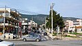 Downtown
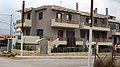 Architecture of Stavros
 Stavros road junction
 Residential architecture
 Main square
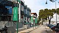 Shopping area
 Residential architecture
 Road behind the church of Metamorfoseos Sotiros
 Night residential street scene
 Looking down from hill
 Middle school


See also
References
External links
Wikiwand - on
Seamless Wikipedia browsing. On steroids.