Byneset
Headland in Trondheim, Norway From Wikipedia, the free encyclopedia
Byneset[1] is a headland located in Trondheim Municipality in Trøndelag county, Norway. The area is located just west of the city of Trondheim. The Trondheimsfjorden lies to the north, Orkdalsfjorden lies to the west, and the Gaulosen bay lies to the south. The villages of Spongdal and Langørjan are both located on the headland.[2]
Byneset | |
|---|---|
Peninsula | |
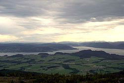
 View of Byneset, looking to the southwest | |
 Interactive map of the peninsula | |
| Coordinates: 63.37632°N 10.13629°E | |
| Location | Trøndelag, Norway |
| Offshore water bodies | Trondheimsfjorden, Orkdalsfjorden, Gaulosen |
| Area | |
| • Total | 78.5 square kilometres (30.3 sq mi) |
In 1999, the 18-hole golf course, Byneset Golfsenter, was built. Anne B. Ragde's novel trilogy Berlinerpoplene – Eremittkrepsene – Ligge i grønne enger (2004–2007) is set in Byneset.[2]
Geography
Byneset is separated from the city of Trondheim by the Bymarka area which is a mountainous, forested area, while Byneset is generally more flat, agricultural land. Agriculture and forestry are the main industries in the area, and there is significant grain and milk production. The landscape in the west is relatively flat, with well-cultivated fields and some marshland (Høstadmyra), while in the east it is heavily hilly with forests and mountains. The highest peak is Storheia at 566 metres (1,857 ft) above sea level.[2]
History
Byneset was populated very early and is rich in archaeological finds from the Stone Age, Bronze Age, and Iron Age. The Byneset Church is a stone church from the 1170s with an altarpiece and pulpit from the 17th century. The church is still in use and it is located on county road 831, about 2.5 kilometres (1.6 mi) west of the village of Spongdal.[2]
The Byneset area was historically part of Byneset Municipality which existed from 1838 until 1964.[2]
Name
The area has been named Bynes or Byneset since the mid-1400s. The first element is the name of the old By farm (Old Norse: býr) which means "farm". The last element is the old name (1400s and earlier) for the medieval parish for this area, Nes, which is the word for "headland" (because this area is located on a headland between the Trondheimsfjorden and Gaulosen fjord.[3]
References
Wikiwand - on
Seamless Wikipedia browsing. On steroids.
