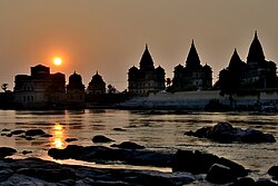
Betwa River
River in northern India From Wikipedia, the free encyclopedia
The Betwa (Sanskrit: वेत्रावती) is a river in Central and Northern India, and a tributary of the Yamuna. It rises in the Vindhya Range (Raisen) just north of Hoshangabad (Narmadapuram) in Madhya Pradesh and flows northeast through Madhya Pradesh and enters Uttar Pradesh after flowing through Orchha.[1] Nearly half of its course, which is not navigable, runs over the Malwa Plateau. The confluence of the Betwa and the Yamuna rivers is in Hamirpur district in Uttar Pradesh where Yamuna flows north and Betwa flows just south of Hamirpur.[1]
| Betwa River Vetravatī | |
|---|---|
 Betwa River near Orchha | |
| Location | |
| Country | India |
| State | Madhya Pradesh, Uttar Pradesh |
| Cities | Vidisha, Sanchi, Ganj Basoda, Kurwai, Orchha, Hamirpur |
| Physical characteristics | |
| Source | Vindhya Range |
| • location | Near Obedullaganj, Vindhya Range north of Hoshangabad[1] |
| Mouth | Yamuna |
• location | Hamirpur, Uttar Pradesh, India |
• coordinates | 25°55′03″N 80°12′45″E |
| Discharge | |
| • location | Rajghat Dam[citation needed] |
| • average | 658 m3/s (23,200 cu ft/s)[citation needed] |
| • maximum | 3,178 m3/s (112,200 cu ft/s) |
| Basin features | |
| Tributaries | |
| • left | Halali, Kaliyasoth, Urwashi |
| • right | Bina, Dhasaan, Jamni |
The Indian navy named one of its frigates INS Betwa in honour of the river.[2]
History

In Sanskrit "Betwa" is Vetravati. This river is mentioned in the epic Mahabharata along with the Charmanwati river[citation needed]. Both are tributaries of Yamuna. Vetravati was also known as Shuktimati. The capital of Chedi Kingdom was on the banks of this river. The length of the river from its origin to its confluence with Yamuna is 590 kilometres (370 mi), out of which 232 kilometres (144 mi) lies in Madhya Pradesh and the balance of 358 kilometres (222 mi) in Uttar Pradesh. In accordance with an inter-state agreement between the states of Uttar Pradesh and Madhya Pradesh in 1973, Betwa River Board (BRB) was constituted under the Betwa River Board Act, 1976. The Union Minister of Ministry of Water Resources, the Chairman of the Board, the Union Minister of Power, Union Minister of State for Water Resources, and the chief ministers and ministers in charge of finance, irrigation and power in Uttar Pradesh and Madhya Pradesh are its members.[3]
Ken-Betwa project
Summarize
Perspective
The Ken-Betwa River Linking Project is a large-scale interlinking initiative aimed at transferring surplus water from the Ken River in Madhya Pradesh to the Betwa River in Uttar Pradesh. The project involves the construction of the Daudhan Dam, a 2.5 km canal, and other infrastructure. The government asserts that the project will help irrigate 1,060,000 hectares [2,600,000 acres] in drought-stricken Bundelkhand, provide drinking water to 6.2 million people, and generate 130 MW of hydropower and solar energy once completed in 2030. The estimated cost of the project is ₹440 billion ($5.06 billion).[4][5]
Environmental Concerns
The project has been the subject of environmental criticism, particularly regarding its impact on Panna Tiger Reserve. Environmentalists warn that the project will submerge nearly 98 sq km of the 543 sq km sanctuary, threatening tiger conservation efforts that successfully reintroduced the species after local extinction in 2009.[5] Concerns have also been raised about the impact on vultures, whose nesting sites may be disturbed by the dam’s construction.[4]
A 2019 expert panel appointed by the Supreme Court of India questioned the project’s economic feasibility and environmental impact, recommending alternative irrigation methods. [5] A 2023 study suggested that river-linking projects could worsen water stress rather than alleviate it.[6] Critics also argue that the government has based its water availability estimates on outdated 2003 data without independent verification.[5]
Government officials defend the project, stating that it has received all necessary environmental clearances and that additional land has been allocated to offset the loss of tiger habitats.[5]
Displacement and Protests
The project will submerge 10 villages and displace 11 more, affecting over 7,000 families, primarily from Gond and Kol indigenous communities. Local residents have staged protests, fearing loss of homes and livelihoods. However, authorities claim that about 90% of affected residents have accepted compensation offers, and efforts are ongoing to identify alternative land for resettlement.[5]
Dams
See also
References
External links
Wikiwand - on
Seamless Wikipedia browsing. On steroids.


