Top Qs
Timeline
Chat
Perspective
Alanallur
Gram panchayat in Kerala, India From Wikipedia, the free encyclopedia

Remove ads
Alanallur is a gram panchayat in the Palakkad district, state of Kerala, India. It is a local government organization that serves the villages of Alanallur-I, Alanallur-II and Alanallur-III.[2]


Remove ads
History
Summarize
Perspective
Alanallur is a village and grama panchayat located in the Mannarkad taluk of Palakkad district, Kerala, India. Historically, the area formed part of the Valluvanad region, an important territorial division in medieval Kerala.
During the medieval period, Valluvanad was ruled by local chieftains and later came under the influence of the Zamorin of Calicut (Samuthiri). Alanallur and its surrounding areas were predominantly agrarian, with settlements developing around paddy cultivation, forest resources, and local water bodies. The region also lay close to inland trade routes connecting Palakkad with the Malabar coast.
Islam reached the area at an early stage through Arab traders, leading to the establishment of mosques and the growth of a significant Muslim population, alongside Hindu communities. Religious and cultural coexistence has historically been a feature of the region.
In the late 18th century, the area briefly came under the control of the Kingdom of Mysore during the invasions led by Hyder Ali and Tipu Sultan. Following the Third Anglo-Mysore War (1792), the region was ceded to the British and became part of the Malabar District of the Madras Presidency. Under British administration, formal land revenue systems, village boundaries, and basic infrastructure were introduced.
After Indian independence in 1947, Alanallur became part of the newly formed state of Kerala in 1956 following the States Reorganisation Act. The Alanallur Grama Panchayat was subsequently constituted under Kerala’s local self-government system. Since then, the area has seen gradual development in education, healthcare, transportation, and public services.
Remove ads
Geography
Summarize
Perspective
Alanallur is a grama panchayat situated in the Mannarkad taluk of Palakkad district, in the Indian state of Kerala. The panchayat lies in the central part of Palakkad district, close to the boundary with Malappuram district. It forms part of the transitional zone between the Western Ghats foothills and the plains of central Kerala.
The panchayat covers an area of approximately 58 square kilometres and comprises the villages of Alanallur-I, Alanallur-II, and Alanallur-III. The terrain is a mix of low-lying agricultural plains and gently undulating terrain, with some elevated areas towards the eastern side.
Several small streams and water channels flow through the area, contributing to local irrigation. The Velliyar River, a tributary of the Bharathapuzha river system, flows near or through parts of the panchayat and serves as an important water source for agriculture and domestic use.
Alanallur experiences a tropical monsoon climate, with heavy rainfall during the southwest and northeast monsoons. Summers are generally warm, while winters are mild. The region’s fertile soil and availability of water support agriculture, with major crops including paddy, coconut, rubber, and arecanut.
The panchayat is bordered by neighbouring local bodies such as Kottoppadam, Thazhekkad, and areas of Malappuram district, and is well connected to nearby towns including Mannarkad and Perinthalmanna by road.
Remove ads
Civic Administration
Alanallur Panchayt Election 2025

Picture Gallery
 Haji School, Edathanattukara
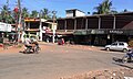 Edathanattukara Town
 Bhandar at the Ayyappa Temple
 Ayyappa Temple jpg


References
External links
Wikiwand - on
Seamless Wikipedia browsing. On steroids.
Remove ads