Adriatic Croatia
Region in Croatia From Wikipedia, the free encyclopedia
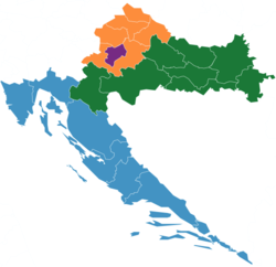
Adriatic Croatia (Croatian: Jadranska Hrvatska) is a subdivision of Croatia as defined by the Nomenclature of Territorial Units for Statistics (NUTS). It is one of the four classified NUTS-2 statistical regions of Croatia. The region incorporates the western parts of the country along the Adriatic Sea. It encompasses an area of 24,705 km2 (9,539 sq mi), and includes the counties–Lika-Senj, Primorje-Gorski Kotar, Dubrovnik-Neretva, Zadar, Split-Dalmatia, Istria, and Šibenik-Knin. With a population of over 1.3 million, it is the most populated of the all the regions in Croatia.
Classification
The country of Croatia has been organized into 20 counties (apart from the capital of Zagreb) for administrative purposes by the County Territories Act of 1997.[5] The Nomenclature of Territorial Units for Statistics (NUTS) organizes the country into four broader level sub-divisions.[6][7] These are classified as a NUTS-2 statistical regions of Hungary, and incorporate one or more counties within it.[8][9] The counties form the NUTS-3 territorial units under them.[5]
Geography
Summarize
Perspective
Adriatic Croatia incorporates the western parts of the country, along the Adriatic Sea. Encompassing an area of 14,197 km2 (5,481 sq mi), it has a 1,777 km (1,104 mi) coastline.[1][10] It shares an international land border with Slovenia in the north, and is bordered by Pannonian Croatia to the east.[11]
The Adriatic Croatian region has a Mediterranean climate. It is characterized by hot, dry summers, and rainy winters. During summers, there is lower precipitation, and heat waves result in sudden temperature rises.[12] The region is also subject to erratic climate conditions. There is sparse vegetation, with low ground water, and thin soil. The coastal regions are heavily eroded.[13] Due to its proximity to the sea, the region is low-lying, and is in the danger of flooding due to rising sea levels.[14]
Sub-regions
Southern Transdanubia incorporates incorporates the counties of Lika-Senj, Primorje-Gorski Kotar, Dubrovnik-Neretva, Zadar, Split-Dalmatia, Istria, and Šibenik-Knin.[8]
| County | Seat | Regions | Area (2006)[15] | Population (2021)[16] | GDP per capita (2019)[17] | Arms | Geographic coordinates |
|---|---|---|---|---|---|---|---|
| Dubrovnik-Neretva | Dubrovnik | Dalmatia | 1,781 km2 (688 sq mi) | 115,564 | €14,673 | 42°39′13″N 18°05′41″E | |
| Istria | Pazin | Istria | 2,813 km2 (1,086 sq mi) | 195,237 | €15,960 | 45°14′21″N 13°56′19″E | |
| Lika-Senj | Gospić | Central Croatia | 5,353 km2 (2,067 sq mi) | 42,748 | €10,725 | 44°42′25″N 15°10′27″E | |
| Primorje-Gorski Kotar | Rijeka | Central Croatia | 3,588 km2 (1,385 sq mi) | 265,419 | €15,232 | 45°27′14″N 14°35′38″E | |
| Split-Dalmatia | Split | Dalmatia | 4,540 km2 (1,750 sq mi) | 423,407 | €10,759 | 43°10′0″N 16°30′0″E | |
| Šibenik-Knin | Šibenik | Dalmatia | 2,984 km2 (1,152 sq mi) | 96,381 | €11,325 | 43°55′44″N 16°3′43″E | |
| Zadar | Zadar | Central Croatia and Dalmatia | 3,646 km2 (1,408 sq mi) | 159,766 | €11,544 | 44°1′5″N 15°53′42″E |
Demographics
With a population of over 1.3 million, it is the most populated of the all the regions in Croatia.[2] Agriculture, livestock and fisheries form a major part of the economy of the region. In 2021, the region had about 441,105 ha (1,089,990 acres) of land under cultivation. Major produce include vegetables, citrus fruits, olives, and grapes. The region has about 84% of the grasslands in the country, and is used for livestock rearing.[12]
References
See also
Wikiwand - on
Seamless Wikipedia browsing. On steroids.

