
TIROS-M
Deactivated weather satellite / From Wikipedia, the free encyclopedia
TIROS-M, also known as ITOS-1 was a weather satellite operated by the Environmental Science Services Administration (ESSA). It was part of a series of satellites called ITOS, or improved TIROS.[3][4] TIROS-M was launched on a Delta rocket on January 23, 1970. The launch carried one other satellite, Australis-OSCAR 5.[2] It was deactivated on June 18, 1971.
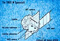 TIROS M diagram
 TIROS M mechanical and thermal test model
 Image of Hurricane Ella prior to its landfall in northeast Mexico from September 11, 1970, taken by ITOS-1
 Sea-surface temperature map of the Southern Hemisphere created from ITOS data from September 6-8, 1970


.jpg)
Quick Facts Mission type, Operator ...
-repair.jpg) TIROS-M | |
| Mission type | Weather |
|---|---|
| Operator | ESSA / NASA |
| COSPAR ID | 1970-008A[1] |
| SATCAT no. | 4320 |
| Spacecraft properties | |
| Manufacturer | RCA Astro |
| Launch mass | 309 kilograms (681 lb) |
| Start of mission | |
| Launch date | January 23, 1970, 11:31 (1970-01-23UTC11:31Z) UTC[2] |
| Rocket | Delta-N6 |
| Launch site | Vandenberg SLC-2W |
| End of mission | |
| Disposal | Decommissioned |
| Deactivated | June 18, 1971 (1971-06-19) |
| Orbital parameters | |
| Reference system | Geocentric |
| Regime | Low Earth Sun-synchronous |
| Perigee altitude | 1,432 kilometers (890 mi) |
| Apogee altitude | 1,478 kilometers (918 mi) |
| Inclination | 101.99 degrees |
| Period | 115 minutes |
| Epoch | January 23, 1971 |
ITOS | |
Close