Loading AI tools
Little Andaman Island (Onge: Gaubolambe) is the fourth largest of the Andaman Islands of India with an area of 707 km2, lying at the southern end of the archipelago. It belongs to the South Andaman administrative district, part of the Indian union territory of Andaman and Nicobar Islands.[6] It lies 88 km (55 mi) south of Port Blair, the capital of Andaman and Nicobar Islands.
Native name: Gaubolambe | |
|---|---|
 Little Andaman Island Location in the Andaman and Nicobar Islands and in the Bay of Bengal  Little Andaman Island Little Andaman Island (Bay of Bengal) | |
| Geography | |
| Location | Bay of Bengal |
| Coordinates | 10.65°N 92.49°E |
| Archipelago | Andaman Islands |
| Adjacent to | Indian Ocean |
| Area | 707 km2 (273 sq mi)[1] |
| Area rank | 1 |
| Length | 24 km (14.9 mi) |
| Width | 43 km (26.7 mi) |
| Coastline | 132 km (82 mi) |
| Highest elevation | 183 m (600 ft)[2] |
| Administration | |
| District | South Andaman |
| Island group | Andaman Islands |
| Island sub-group | Little Andaman Group |
| Tehsil | Little Andaman Tehsil |
| Largest settlement | Kwate-tu-Kwage (Hut Bay) |
| Demographics | |
| Population | 18,823 (2011) |
| Pop. density | 26.6/km2 (68.9/sq mi) |
| Ethnic groups | Onge, other Indians |
| Additional information | |
| Time zone | |
| PIN | 744207[3] |
| Telephone code | 031927[4] |
| ISO code | IN-AN-00[5] |
| Official website | www |
| Literacy | 84.4% |
| Avg. summer temperature | 30.2 °C (86.4 °F) |
| Avg. winter temperature | 23.0 °C (73.4 °F) |
| Sex ratio | 1.2♂/♀ |
| Census Code | 35.640.0009 |
| Official Languages | Hindi, English |
The island is in the Bay of Bengal and belongs to the Little Andaman Group, and is separated from Rutland Island in Great Andaman by the Duncan Passage. The Little Andaman Group is the counterpart of the Great Andaman island group.
The low-lying island has widespread rainforest and several rare species of marine turtle. Little Andaman Island has white sandy beaches and bewitching waterfalls. The Little Andaman Lighthouse (a.k.a. Richardson's Lighthouse) is located 14 km south by road from Hut Bay port and is situated on the Southern tip of Little Andaman Island.[7]
Climate
| Climate data for Little Andaman (Hut Bay) 1981–2010, extremes 1969–2012 | |||||||||||||
|---|---|---|---|---|---|---|---|---|---|---|---|---|---|
| Month | Jan | Feb | Mar | Apr | May | Jun | Jul | Aug | Sep | Oct | Nov | Dec | Year |
| Record high °C (°F) | 34.4 (93.9) |
35.2 (95.4) |
36.4 (97.5) |
36.4 (97.5) |
35.8 (96.4) |
36.3 (97.3) |
36.4 (97.5) |
35.6 (96.1) |
33.6 (92.5) |
34.8 (94.6) |
34.0 (93.2) |
34.4 (93.9) |
36.4 (97.5) |
| Mean daily maximum °C (°F) | 30.9 (87.6) |
31.5 (88.7) |
32.5 (90.5) |
33.2 (91.8) |
31.9 (89.4) |
30.9 (87.6) |
30.6 (87.1) |
30.3 (86.5) |
30.2 (86.4) |
30.7 (87.3) |
30.9 (87.6) |
30.7 (87.3) |
31.2 (88.2) |
| Mean daily minimum °C (°F) | 22.6 (72.7) |
21.3 (70.3) |
21.8 (71.2) |
23.0 (73.4) |
24.1 (75.4) |
24.9 (76.8) |
24.2 (75.6) |
24.5 (76.1) |
23.9 (75.0) |
23.1 (73.6) |
23.3 (73.9) |
23.3 (73.9) |
23.3 (73.9) |
| Record low °C (°F) | 14.1 (57.4) |
13.6 (56.5) |
16.3 (61.3) |
15.0 (59.0) |
18.2 (64.8) |
16.4 (61.5) |
17.8 (64.0) |
18.6 (65.5) |
15.8 (60.4) |
15.7 (60.3) |
16.6 (61.9) |
15.4 (59.7) |
13.6 (56.5) |
| Average rainfall mm (inches) | 32.7 (1.29) |
40.4 (1.59) |
50.8 (2.00) |
104.8 (4.13) |
376.7 (14.83) |
305.2 (12.02) |
330.7 (13.02) |
312.3 (12.30) |
439.1 (17.29) |
316.7 (12.47) |
270.9 (10.67) |
78.3 (3.08) |
2,658.6 (104.67) |
| Average rainy days | 1.8 | 1.6 | 2.5 | 5.2 | 15.8 | 14.5 | 14.4 | 15.9 | 16.8 | 14.3 | 11.6 | 4.5 | 118.9 |
| Average relative humidity (%) (at 17:30 IST) | 77 | 75 | 75 | 76 | 83 | 85 | 85 | 85 | 87 | 87 | 85 | 80 | 82 |
| Source: India Meteorological Department[8][9] | |||||||||||||
Administratively, Little Andaman Island is part of Little Andaman Tehsil.[10]
The island is home to the indigenous Onge tribe, who call the island Egu Belong, and has been a tribal reserve since 1957. Settlers from Bengal and other places also live here. As per the census of 2011, the population was 18,823 in 4,093 households, spread among 18 villages. The main village of Kwate-tu-Kwage is located on Hut Bay.
Hut Bay wharf, a deep water wharf that can be approached through a gap in the coral reef, on the east coast of the island is the entry point of Little Andaman Island. Daily boat services connect Hut Bay wharf with Port Blair in seven hours voyage. Additionally, there are a helicopter services by Pavan Hans Ltd. and a sea plane connection available between Port Blair and Hut Bay. The flight time by helicopter or sea plane is approximately 40 minutes.
| Airlines | Destinations |
|---|---|
| Jal Hans | Port Blair |
There is a road alongside the east coastal line.
Little Andaman offers surfing, boating through the creeks, and visits to an elephant logging plantation. Butler Bay, 14 km from the Hut Bay Jetty, is a beach popular among tourists due to coral viewing, surfing and other marine activities. Tourist huts are available on the seashore itself flanked by the coconut plantation. Netaji Nagar Beach is 11 km from the Hut Bay jetty.[11]
 Outline map of the Andaman Islands, with the location of Little Andaman highlighted (in red).
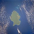 1990 Space Shuttle image of Little Andaman


Wikiwand in your browser!
Seamless Wikipedia browsing. On steroids.
Every time you click a link to Wikipedia, Wiktionary or Wikiquote in your browser's search results, it will show the modern Wikiwand interface.
Wikiwand extension is a five stars, simple, with minimum permission required to keep your browsing private, safe and transparent.