| Waterfall |
Image |
Flow rate (m3/s) |
Drop (m) |
Width (m) |
River |
Countries |
Coordinates |
Notes |
|---|
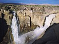
| Inga Falls |
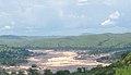 |
25,768 (est.) |
21 |
914 |
Congo |
 DRC DRC |
5°26′56″S 13°35′18″E |
The Inga falls, whose status as a true waterfall is controversial, are currently incorporated into the Inga I and Inga II hydroelectric facilities. The volume of the river diverted is approximately 30% of the average discharge. The Grand Inga Dam, potentially the world's largest by generating capacity, is also proposed to be built on the falls.[1] |
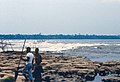
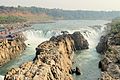
| Livingstone Falls |
 |
25,060 |
6 |
701 |
Congo |
DRC
 Congo Congo
|
4°52′41″S 14°26′08″E |
A set of rapids that drops 6 metres (20 ft). Located at the southern end of the Republic of the Congo's border with the Congo River.[2] |
| Boyoma Falls |
 |
16,990 |
5 |
1,372 |
Lualaba, Congo |
DRC |
0°29′27″N 25°12′24″E |
A series of seven cataracts, also referred to as the Stanley Falls. The last and most significant of these cataracts, at Kisangani, is known as Wagenia.[3] The Boyoma Falls marks the transition to the Congo River from the Lualaba River.[4] |
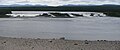
| Khone Phapheng Falls |
 |
11,610 |
21 |
10,783 |
Mekong |
 Laos Laos |
13°57′18″N 105°54′10″E |
A series of falls and rapids that when measured end-to-end is over 10 kilometres in width, making it the world's widest waterfall. Largest waterfall in Asia by average flow rate.[5] |
| Pará Falls |
 |
3,540 |
64 |
5,608 |
Caura |
 Venezuela Venezuela |
6°19′01″N 64°30′33″W |
Largest extant waterfall in South America by average flow rate.[6] |
| Paulo Afonso Falls |
 |
2,832 |
59 |
18 |
São Francisco |
 Brazil Brazil |
9°23′21″S 38°11′45″W |
Flow regulated by the Paulo Afonso Hydroelectric Complex.[7] |
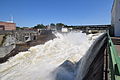
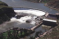
| Niagara Falls |
 |
2,407 |
51 |
1,204 |
Niagara |
 Canada Canada
 United States United States |
43°04′48″N 79°04′16″W |
Largest extant waterfall in North America by average flow rate. Flow regulated by the Robert Moses Niagara and Sir Adam Beck Hydroelectric Generating Stations.[8] |
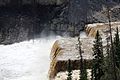
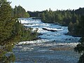
| Vermilion Falls |
 |
1,812 |
5 |
1,829 |
Peace |
Canada |
58°22′11″N 114°52′18″W |
[9] |
| Iguazú Falls |
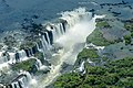 |
1,746 |
64 |
2,682 |
Iguazú |
 Argentina Argentina
Brazil |
25°41′43″S 54°26′12″W |
[10] |
| Limestone Falls |
 |
1,464 |
22 |
335 |
Caniapiscau |
Canada |
57°28′45″N 69°18′36″W |
Flow regulated by the KA-3 Dam of the Caniapiscau Reservoir.[11] |
| Pyrite Falls |
 |
1,464 |
8 |
579 |
Caniapiscau |
Canada |
57°26′00″N 69°14′32″W |
Flow regulated by the KA-3 Dam of the Caniapiscau Reservoir.[12] |
| Victoria Falls |
 |
1,088 |
105 |
1,707 |
Zambezi |
 Zambia Zambia
 Zimbabwe Zimbabwe |
17°55′27″S 25°51′22″E |
Produces the largest sheet of falling water in the world.[13] |
| Virginia Falls |
 |
1,000 |
90 |
259 |
South Nahanni |
Canada |
61°36′27″N 125°44′20″W |
[14] |
| Ngonye Falls |
 |
963 |
25 |
? |
Zambezi |
Zambia |
16°39′08″S 23°34′17″E |
Also known as Sioma Falls.[15] |
| Shale Falls |
 |
934 |
18 |
610 |
Caniapiscau |
Canada |
56°44′39″N 69°01′04″W |
Flow regulated by the KA-3 Dam of the Caniapiscau Reservoir.[16] |
| Shivanasamudra Falls |
 |
934 |
98 |
305 |
Kaveri |
 India India |
12°17′33″N 77°10′03″E |
This waterfall divides around Sivasamudram Island. One side is known as Gaganachukki and the other side is known as Barachukki.[17] |
| Willamette Falls |
 |
928 |
13 |
457 |
Willamette |
United States |
45°21′05″N 122°37′09″W |
Prior to the development of the Oregon City area, it is thought the falls may have spanned as much as 762 metres across. Flow regulated by the T. W. Sullivan Hydroelectric Plant.[18] |
| Kongou Falls |
 |
900 |
56 |
3,200 |
Ivindo |
 Gabon Gabon |
0°17′17″N 12°35′17″E |
[19] |
| Kootenai Falls |
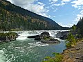 |
731 |
9 |
258 |
Kootenay |
United States |
48°27′20″N 115°45′48″W |
[20] |
| Laksforsen [no] |
 |
700 |
17 |
? |
Vefsna |
 Norway Norway |
65°37′25″N 13°17′26″E |
[21] |
| Oatmeal Rapids |
 |
697 |
? |
? |
Rupert River |
Canada |
51°21′24″N 77°25′11″E |
Despite being nominally rapids, the falls are steep enough as to not meet the technical definition due to the final drop.[22] |
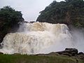
| Kaieteur Falls |
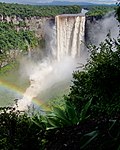 |
663 |
226 |
113 |
Potaro |
 Guyana Guyana |
5°10′30″N 59°28′50″W |
[23] |
| Rheinfall |
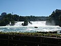 |
595 |
24 |
122 |
Rhine |
 Switzerland Switzerland |
47°40′40″N 8°36′56″E |
Largest waterfall in Europe by average flow rate.[24] |
| Sarp Falls |
 |
577 |
21 |
? |
Glomma |
Norway |
59°16′34″N 11°07′51″E |
Second-largest waterfall in Europe by average flow rate.[25] |
| Kalandula Falls |
 |
566 |
105 |
411 |
Lucala |
 Angola Angola |
9°04′26″S 16°00′03″E |
[26] |
|
| Chutes de Shawinigan [fr] |
 |
513 |
50 |
? |
Saint-Maurice |
Canada |
46.531360°N 72.761830°W / 46.531360; -72.761830 (Shawinigan Falls) |
Flow regulated by the Shawinigan 2 and Shawinigan 3 dams.[27] |
| Chaudière Falls |
 |
500 |
35 |
240 |
Chaudière |
Canada |
46°42′47″N 71°17′10″W |
Flow regulated by the Sartigan Dam.[28] |
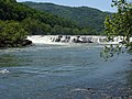
| Great Falls |
 |
474 (est.) |
? |
107 |
Potomac |
United States |
38°59′51″N 77°15′09″W |
Flow regulated by the Washington Aqueduct.[29] |
| Kazan Falls |
 |
459 |
? |
? |
Kazan River |
Canada |
63°42′50″N 95°50′41″W |
[30] |
| Granite Falls |
 |
453 |
21 |
? |
Caniapiscau |
Canada |
55°50′42″N 68°25′25″W |
Flow regulated by the KA-3 Dam of the Caniapiscau Reservoir.[31] |
| Chutes de la Lobé [fr] |
 |
390 |
? |
? |
Lobé River |
 Cameroon Cameroon |
2°52′56″N 9°53′49″E |
[32] |
| Hidden Falls |
|
425 |
30 |
? |
Yarlung Tsangpo |
 China China |
29°46′34″N 95°10′54″E |
[33] |
| Ulaan Tsutgalan Waterfall |
 |
380 |
10 |
24 |
Orkhon River |
 Mongolia Mongolia |
50°15′00″N 106°08′20″E |
The flow rate heavely altered by mining operations.[34] |
| Saint Anthony Falls |
 |
370 |
15 |
? |
Mississippi River |
US |
44°58′54″N 93°15′31″W |
Shape and flow rate severely altered by large hydroelectric developments. |
| Urriðafoss |
 |
360 |
4 |
229 |
Þjórsá |
 Iceland Iceland |
63°55′30″N 20°40′22″W |
[35] |
| Little Eaton Canyon Falls |
 |
317 |
|
|
Caniapiscau |
Canada |
55°31′46″N 68°17′40″W |
Flow regulated by the KA-3 Dam of the Caniapiscau Reservoir.[36] |
| Lower Eaton Canyon Falls |
 |
317 |
|
|
Caniapiscau |
Canada |
55°33′46″N 68°11′50″W |
Flow regulated by the KA-3 Dam of the Caniapiscau Reservoir.[37] |
| Nastapoca Falls |
 |
317 |
35 |
35 |
Nastapoca |
Canada |
56°54′54″N 76°31′46″W |
[38] |
| Tuktu Falls |
|
317 |
|
|
Caniapiscau |
Canada |
55°32′36″N 68°14′44″W |
Flow regulated by the KA-3 Dam of the Caniapiscau Reservoir.[39] |
| Twin Falls |
|
317 |
48 |
61 |
Nastapoca |
Canada |
56°53′54″N 76°24′12″W |
[40] |
| Upper Eaton Canyon Falls |
 |
317 |
|
|
Caniapiscau |
Canada |
55°33′29″N 68°12′57″W |
Flow regulated by the KA-3 Dam of the Caniapiscau Reservoir.[41] |
| Augrabies Falls |
 |
313 |
56 |
24 |
Orange |
 South Africa South Africa |
28°35′29″S 20°20′25″E |
[42] |
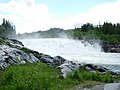
| Murchison Falls |
 |
300 |
43 |
15 |
White Nile |
 Uganda Uganda |
2°16′43″N 31°41′09″E |
Flow regulated by the Karuma Hydroelectric Power Station.[43] |
| Dhuandhar Falls |
 |
294 |
30 |
? |
Narmada River |
India |
23°07′30″N 79°48′53″E |
[44] |
| Alexandra Falls |
 |
282 |
32 |
117 |
Hay River |
Canada |
60°30′02″N 116°16′46″W |
[45] |
| Louise Falls |
 |
282 |
15 |
183 |
Hay River |
Canada |
60°30′12″N 116°14′29″W |
[46] |
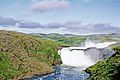
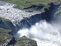
| Dettifoss |
 |
269 |
51 |
171 |
Jökulsá á Fjöllum |
Iceland |
65°48′53″N 16°23′04″W |
[47] |
| Hafragilsfoss |
 |
269 |
27 |
85 |
Jökulsá á Fjöllum |
Iceland |
65°49′56″N 16°23′57″W |
[48] |
| Réttarfoss |
 |
269 |
? |
? |
Jökulsá á Fjöllum |
Iceland |
65°52′47″N 16°26′09″W |
[49] |
| Selfoss |
 |
269 |
13 |
387 |
Jökulsá á Fjöllum |
Iceland |
65°48′18″N 16°23′12″W |
[50] |
| Kanawha Falls |
 |
255 |
? |
? |
Kanawha River |
United States |
38.138°N 81.213°W / 38.138; -81.213 (Sandstone Falls) |
[51] |
| Ristafallet [sv] |
 |
250 |
14 |
50 |
Indalsälven |
 Sweden Sweden |
63.31256°N 13.350903°E / 63.31256; 13.350903 (Ristafallet) |
[52] |
| Sandstone Falls |
 |
222 |
4 |
549 |
New River |
United States |
37°45′24″N 80°54′21″W |
[53] |
| Huka Falls |
 |
220 |
11 |
? |
Waikato River |
 New Zealand New Zealand |
38°38′55″S 176°05′24″E |
[54][55] |
| Félou Falls |
 |
216 |
13 |
? |
Senegal River |
 Mali Mali |
14°21′13″N 11°20′43″W |
Flow regulated by the Félou Hydroelectric Plant.[56] |
| Gouina Falls |
 |
216 |
16 |
500 |
Senegal River |
Mali |
14°00′54″N 11°06′09″W |
Flow regulated by the Gouina Hydroelectric Plant.[57] |
| Big Falls |
 |
213 |
27 |
183 |
Missouri River |
United States |
47°34′08″N 111°07′26″W |
Flow regulated by the Ryan Dam.[58][59] |
| Black Eagle Falls |
 |
213 |
8 |
183 |
Missouri River |
United States |
47°31′11″N 111°15′44″W |
Flow regulated by the Black Eagle Dam.[60][59] |
| Crooked Falls |
|
213 |
6 |
457 |
Missouri River |
United States |
47°32′06″N 111°11′47″W |
Flow regulated by the Rainbow Dam.[61][59] |
| Rainbow Falls |
 |
213 |
13 |
305 |
Missouri River |
United States |
47°32′00″N 111°12′19″W |
Flow regulated by the Rainbow Dam.[62][59] |
| Rusumo Falls |
 |
210 |
15 |
40 |
Kagera River |
 Rwanda Rwanda  Tanzania Tanzania |
2°22′57″S 30°47′00″W |
[63] |
| Målselvfossen [no] |
 |
196 |
22 |
600 |
Målselva |
Norway |
69°02′09″N 18°39′16″E |
[64] |
| Storforsen |
 |
187 |
35 |
76 |
Pite River |
Sweden |
65°50′59″N 20°24′16″E |
[65] |
| Kabwelume Falls |
 |
181 |
? |
? |
Kalungwishi River |
Zambia |
9°31′29″S 29°21′05″E |
[66] |
| Lumangwe Falls |
 |
181 |
? |
? |
Kalungwishi River |
Zambia |
9°32′32″S 29°23′11″E |
[67] |
| Zongo Falls |
 |
179 |
? |
? |
Inkisi River |
DRC |
4.777431°S 14.905735°E / -4.777431; 14.905735 (Zongo Falls) |
Flow regulated by the Zongo II Hydroelectric Power Station.[68] |
| Rearguard Falls |
 |
171 |
6 |
61 |
Fraser River |
Canada |
52°58′24″N 119°21′51″W |
[69] |
| Cohoes Falls |
 |
161 |
20 |
290 |
Mohawk River |
United States |
42°47′17″N 73°42′31″W |
Flow regulated by the School Street Hydroelectric Generating Facility.[70][71] |
| Epupa Falls |
 |
160 |
37 |
1500 |
Cunene River |
Angola  Namibia Namibia |
17°00′00″S 13°14′36″E |
Flow regulated by the Ruacana Hydroelectric Power Station.[72] |
| Ruacana Falls |
 |
160 |
120 |
700 |
Cunene River |
Angola Namibia |
17°23′38″S 14°13′04″E |
Flow regulated by the Ruacana Hydroelectric Power Station.[72] |
| Jog Falls |
 |
153 |
253 |
472 |
Sharavati River |
India |
14°13′45″N 74°48′45″E |
Flow regulated by the Linganamakki Dam.[73] |


.jpg)


_and_the_Hornblower_Niagara_Cruises_boat;_Niagara_Falls.JPG)


.jpg)


.JPG)


.jpg)

.jpg)
.jpg)


.JPG)


.jpg)
_-_panoramio.jpg)
.jpg)


.jpg)