Loading AI tools

City in Karnataka, India From Wikipedia, the free encyclopedia
Karwar is a seaside city, taluka, and administrative headquarters of Uttara Kannada district lying at the mouth of the Kali river on the Kanara coast of Karnataka state, India.
This article needs additional citations for verification. (November 2022) |
Karwar
Kādwād Carwar | |
|---|---|
Municipality /Taluk | |
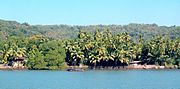
.jpg)   Clockwise from the Top: Tagore Beach, Arabian Sea from Sadashivgad fort, Majali Beach, Bridge over Kali River | |
 Karwar  Karwar | |
| Coordinates: 14.80°N 74.13°E | |
| Country | |
| State | Karnataka |
| Region | Karavali |
| District | Uttara Kannada |
| Government | |
| • Type | City Municipal Council |
| Area | |
| • Urban | 36.95 km2 (14.27 sq mi) |
| • Taluk | 743.4 km2 (287.0 sq mi) |
| Elevation | 6 m (20 ft) |
| Population (2011)[2] | |
| • CMC+Outgrowth | 77,139 |
| • Taluk | 155,213 |
| Demonym | Karwarkar |
| Language | |
| • Official | Kannada |
| • Local | Konkani, Kannada |
| Time zone | UTC+5:30 (IST) |
| PIN | 581301 |
| Telephone code | 91-8382 |
| Vehicle registration | KA 30 |
| HDI (2014) | |
| Literacy (2014) | 89.91[3] |
| Sex ratio (2014) | 989 ♀/1000 ♂[3] |
| Website | karwarcity |
Karwar is a popular place known for the Naval Base Karwar.
The Karwar Port is acclaimed as one of the best natural all-weather ports on the West Coast, located in Uttar Kannada district at the Southern side of the Kali River. caters to the trading needs of northern Karnataka, Andhra Pradesh and Maharashtra. The port is located beside the National Highway (NH66) that connects Mumbai and Kochi, one of the country’s busiest corridors. Also, it is only 8 km away from the Konkan Railway network.[4]
Karwar, also known locally as "Kādwād", derived its name from the nearby village of "Kade-Wādā". In the local Kannada, Kade means "last" and Wādā means "precinct". Hence, Kade-Wādā ("the last neighbourhood") referred to the southernmost Konkani-speaking village. During the Crown rule in India, the name "Karwar" was spelt as "Carwar".[5] The ancient name was "Baithkhol"—from an Arabic term Bait-e-kol— meaning the "bay of safety". This is in the Indian history for maritime trade wherein black peppercorns, cardamom, and muslin cloth were exported from this Kādwād port and after the war with Veer Henja Naik (1803), the port activities were shifted to Baithkhol. Thereafter, the port of Kādwād was isolated and Kurmagad Fort was activated by the Portuguese.


Karwar township was built by the British in the year 1857 after the Mutiny. Karwar is popularly known as the "Kashmir of Karnataka". Prior to 1857, Karwar did not exist as a town. Honnavara was the district headquarters of Canara district consisting up to Mangalore to Kodibag Karwar, up till Kali river; and Karwar village (Kādwād) existed as hamlets like Habbuwada, Kajubag, Kodibag, Kone, Baad, Kathinkon, Sunkeri, Shirwad, and Binaga. After that, the river bank towards the north was under the rule of Sadhashiv Nayak and Maratha Confederacy. After the mutiny of 1857, the British made division of Canara District into two parts as South Canara with headquarters at Mangalore attached to Madras Presidency and North Canara with headquarters at the newly built town Karwar, which was attached to Bombay Presidency. It is a planned city like Panaji, Mumbai, Dharwad, and Bengaluru. After the rule of the Indian Government from 1947, Karwar is more or less neglected politically and kept without major developments.
Portuguese traders knew Karwar as Cintacora, Chitrakul, Chittakula or Sindpur. In 1510, the Portuguese captured and burnt a fort at Karwar. They called it Fort Pir, Forte de Piro or Pito due to the presence of a Muslim Dargah (tomb of a Sufi saint, Shahkaramuddin).
In 1638 the English Trading Courteen Association established a factory at Kadwad village, 6 km east of Karwar and traded with merchants from Arabia and Africa. The common commodities were muslin, black pepper, cardamom, cassier and coarse blue cotton cloth. In 1649 the Courteen Association merged with the British East India Company, and Karwar became a company town. The East India Company built fighting ships in the Karwar harbour. For example, the Britannia (1715) which had 18 guns was built to defend Bombay from attacks by Maratha Koli[6] admiral Kanhoji Angre.[7]
In the 1700s, Karwar was a part of the Maratha Empire. Having marched from Bednore in the south, visiting on his way the sacred temple at Gokarna, Shivaji seized Ankola and the next day came to Karwar (then known as Kadwad). Both the East India Company and Sher Shah, the Sardar of Bijapur, were very much alarmed at this sudden development. They collected a huge amount and offered it to Shivaji, praying that they may be spared. Satisfied at the recognition of his authority, Shivaji crossed the Kali River and conquered Sadashivgad on 21 February 1665.
In 1784, at the time of the Treaty of Mangalore between Tipu Sultan and the East India Company, "Treaty of Mangelore" Archived 20 July 2008 at the Wayback Machine Project South Asia.</ref> After the defeat of the Marathas in the Third Anglo-Maratha War, Karwar was captured by the British. Kot Siveshvar, another fortress, was built near Karwar (in Siveshvar village) by the Sultan of Bijapur to counterattacks from the north.
At the ruins of Fort Siveshvar are a Muslim graveyard and a tunnel at the eastern gate. The Bengali poet and Nobel laureate Rabindranath Tagore, who visited Karwar in 1882, dedicated a chapter of his memoirs to this town.[8] At 22 years, Tagore stayed with his second brother, Satyendranath Tagore, who was a district judge in Karwar.
From 1862 until the re-organization of the Indian states after Independence, Uttara Kannada district was a part of the Bombay Presidency. During this period, major public works carried out included the improvement of roads, the building of a wharf, wharf road and a sea wall at the Karwar port as well as the construction of a multi-floor storage building, staff housing, a post office, kutcheri (kutcherries or zamindar's offices) and a Christian burial ground.[9] At the same time, the local Konkani-speaking people had close connections with Mumbai and Goa. Many Marathi middle schools were established in Karwar and Joida taluks, despite the fact that the local populace mostly were Konkani native speakers.
During World War II Karwar was an Indian Naval training site.[10]: 172
Post-Independence Karwar was made a part of newly formed Mysore state following requests by the people of Karwar. Karwar during the 1950–60s played important role in the Konkani language agitation, helping cement Konkani as an independent language during Konkani conferences held in Karwar. The city played an important role in Konkan culture and Konkani culture hosting many Konkani conferences to promote the language. There have been demographic shifts since the state reorganizations act, and Karwar is no longer the stronghold for Konkani culture and has been overtaken by Panaji (or Panjim), Goa (after Goa achieved statehood) and by Mangalore[11] .The city is also neglected by the state government and devoid of development. Spots of attractions are usually underfunded, relatively little money is allowed for development and people have to constantly rely on the neighboring state of Goa to carry out their needs.[12]

Karwar is a seaport on the west coast of peninsular India. To the east are the Western Ghats. Karwar is situated on the banks of the Kali river which flows west to the Arabian sea from its headwaters at Bidi village in the Western Ghats. The Kali river has a length of about 150 km (93 mi) and is the main source of irrigation in the region.
Baitkhol port at Karwar is a natural harbour with land side hills and ocean side islands protecting it from cyclonic weather. The four fathom mark lies close to the shore. The tidal range is 1.5–2.5 m (5–8 ft).[10]: 172

Several small mangrove covered islands lie off the Kali river estuary including Anjediva Island and Devagadaguda Islands. The sub-tidal regions of the islands have a high biodiversity, although the waters off Karwar have recorded higher than normal faecal coliform counts.[13]: 248
Karwar lies on a coastal strip known as the Monsoon Coast.[14] Karwar has hot and humid summers (27–34 °C (81–93 °F)) from March to May where the temperature may peak to 38 °C (100 °F). The Arabian Sea is warm throughout the year. Winters from December to February are mild (23–29 °C (73–84 °F)) and seldom plummet to 20 °C (68 °F). The windy monsoon period from June to September has an average rainfall of over 400 cm (160 in).
| Climate data for Karwar (1981–2010, extremes 1901–2012) | |||||||||||||
|---|---|---|---|---|---|---|---|---|---|---|---|---|---|
| Month | Jan | Feb | Mar | Apr | May | Jun | Jul | Aug | Sep | Oct | Nov | Dec | Year |
| Record high °C (°F) | 38.2 (100.8) |
39.1 (102.4) |
39.6 (103.3) |
38.9 (102.0) |
37.4 (99.3) |
36.6 (97.9) |
32.8 (91.0) |
33.3 (91.9) |
34.0 (93.2) |
39.4 (102.9) |
37.8 (100.0) |
37.2 (99.0) |
39.6 (103.3) |
| Mean daily maximum °C (°F) | 32.8 (91.0) |
32.4 (90.3) |
32.7 (90.9) |
33.5 (92.3) |
33.5 (92.3) |
30.9 (87.6) |
29.6 (85.3) |
29.5 (85.1) |
30.2 (86.4) |
31.9 (89.4) |
33.5 (92.3) |
33.4 (92.1) |
32.0 (89.6) |
| Mean daily minimum °C (°F) | 19.2 (66.6) |
19.7 (67.5) |
22.7 (72.9) |
25.3 (77.5) |
26.7 (80.1) |
25.1 (77.2) |
24.5 (76.1) |
24.3 (75.7) |
24.2 (75.6) |
23.9 (75.0) |
22.2 (72.0) |
20.4 (68.7) |
23.2 (73.8) |
| Record low °C (°F) | 12.7 (54.9) |
11.6 (52.9) |
15.6 (60.1) |
17.2 (63.0) |
20.3 (68.5) |
18.3 (64.9) |
18.3 (64.9) |
20.3 (68.5) |
20.5 (68.9) |
16.8 (62.2) |
13.7 (56.7) |
12.5 (54.5) |
11.6 (52.9) |
| Average rainfall mm (inches) | 0.1 (0.00) |
0.1 (0.00) |
0.2 (0.01) |
8.9 (0.35) |
123.1 (4.85) |
964.8 (37.98) |
965.0 (37.99) |
684.8 (26.96) |
305.6 (12.03) |
194.5 (7.66) |
31.4 (1.24) |
7.0 (0.28) |
3,285.6 (129.35) |
| Average rainy days | 0.1 | 0.0 | 0.1 | 0.6 | 4.5 | 22.6 | 26.5 | 24.3 | 13.6 | 7.3 | 2.1 | 0.5 | 102.2 |
| Average relative humidity (%) (at 17:30 IST) | 60 | 63 | 68 | 68 | 71 | 82 | 85 | 85 | 81 | 76 | 65 | 59 | 72 |
| Source: India Meteorological Department[15][16] | |||||||||||||
The total population in Karwar town with outgrowth is 77,139 as of 2011 by Indian Government. As of 2011, Karwar had an average literacy rate of 93%, higher than the national average of 74%. Males constitutes 49.7% of population and 50.3% are females.[17][3] In Karwar, 10% of the population were children under six years of age.
Karwar taluka is majorly Konkani by first language speakers. It was part of the Bombay Presidency during the British colonial rule, before the reorganization of states. The native Konkani speakers had close connections with Bombay which extended to matrimonial relations too. Many Marathi-medium schools were also established in Karwar and Joida talukas. Marathi films were often released in Karwar. The visit of Marathi drama troupes from Bombay and Poona was an annual feature. However, Konkani-speaking people were disenchanted when Marathis began to claim Konkani as a dialect of Marathi. They disputed it and asserted that Konkani had independent status as a language. It was the native Konkani-speaking people led by late P. S. Kamat who argued before Mahajan Commission that Karwar was an integral part of Karnataka.
There have been recent assertions by both Maharashtra and Goa that Karwar should belong to their states.[21][22]

Most people in Karwar are Hindu. Christianity was introduced to Karwar by the Portuguese while ruling Goa in the 16th and 17th centuries and contemporary Karwari Catholics are descendants of those early Christians. Muslim seafaring traders migrated to Karwar from the Deccan (Bahamani) kingdoms. Karwar was called Baithkol meaning the "house of safety" or Bait-e-kol meaning "place of safety" in Arabic. Muslim villages in Karwar include: Shiveshvar, Chittakula, Sawar Pai, and Hotegali. Islamic tradition holds that two brothers, descendants of Ali, the son-in-law of Muhammad, settled in Shiveshvar and made the village a place of Islamic learning. In Shiveshvar, there are three shrines dedicated to Muslim saints: Gaiby Pir, Nizam Pir, and Shamshuddin pir-in Kot.

Karwar is an agricultural region. The common crops are rice, groundnuts, green vegetables, onions, watermelons, and flowers. Other primary industries include animal husbandry, sericulture, horticulture, beekeeping, gathering and lumbering and the growing of homeopathic medicinal plants.
The coastal location of Karwar lends to fishing and fisheries which are concentrated in Harikanth, Konkan Kharvis, Gabiths and Ambigas. The common types of fish are mackerel, sardines, hardheads and prawns. Fishing is done from land with nets or from boats such as pandy (motor launch) and dhoni (dug out canoes). There is also mechanised trawling. The brackish water of the Kali estuary is suitable for prawn farming.[23]

Members of the Daivadnya Brahmin caste are engaged in jewellery design, manufacturing and goldsmithing. Leather works are common. Since 1638 when William Counten opened a mill, Karwar town has been a producer of fine muslin.[citation needed] In the 1660s the factory was prosperous, exporting the finest muslins in Western India; the weaving country was inland to the east, at Hubli and other centres, where as many as 50,000 weavers were employed. Besides the great export of muslin, Karwar provided pepper, cardamoms, cassia, and coarse blue cotton cloth (dungan). I[24][citation needed]
In Binaga township, a chemical company Aditya Birla Chemicals (earlier owned by Ballarpur Industries Ltd / Solaris Chemtech), manufactures caustic soda lye and flakes, chlorine, hydrochloric acid, phosphoric acid, kestra pipes and bromine.[13]: 246
At Kaiga, 50 kilometres (31 mi) away, the Nuclear Power Corporation of India operates an 880 MW nuclear power plant. The Karnataka Power Corporation Ltd. operates a dam and 150 MW power house between Kadra and Mallapur townships, approximately 33 kilometres (21 mi) from Karwar town.
The Indian Navy operates a naval base at a bay near Binaga township. It is the navy's third largest base. The base was founded as part of Project Seabird. Casurina beach near Binaga (now called Kamat Bay) and Arga beach were incorporated into naval property. The public has access to the base during Navy Week in December and in visiting educational groups. The naval base includes a civilian support community at Amadalli, a ship lift and an hospital. INS Kadamba is the homeport of India's largest aircraft carrier INS Vikramaditya.
INS Vajrakosh, commissioned on 9 September 2015, is the latest establishment of the Indian Navy at Karwar which will serve as special storage facility for specialised armaments and missiles. INS Vajrakosh will have all the required infrastructure and will be staffed by specialists to provide specialised servicing facilities for these sophisticated missiles and ammunition.[25]
Aditya Birla Chemicals (India) (ABCIL) is a unit of the Aditya Birla Group.
ABCIL has also acquired chlor-alkali and phosphoric acid division of Ballarpur Industries Ltd / Solaris Chemtech Industries Limited, based in Karwar, Karnataka.


The proposed Karwar Airport will be built by the Indian Navy at Alageri village[26] near Ankola, in Karnataka. The Airports Authority of India (AAI) will operate a civil enclave at the naval air base which is part of the Navy's Rs 100 billion Phase 2 of Project Seabird. After the construction Karwar will be the second city in Karnataka to have all 3 major modes of transport (Air, Sea, Land)

The Konkan Railway connects Karwar to most major towns and cities. Karwar has three railway stations: Karwar, Asnoti and Harwada. The nearest Goan station is Canacona, 36 km away. Madgaon Junction lies 68 km to the north.[27] and Mangalore Junction 253 km to the south.

Karwar port is located at Baithkol, Karwar Bay. Hills and coastal islands make the port a natural harbour, sheltered from the Arabian sea. The port which is operated by the Government of Karnataka, services the hinterland of northern Karnataka, Goa and southern Maharashtra.
The length of the port is 355 metres (388 yd). The quay has two berths, with a draft capacity of 9.25 metres (30.3 ft). Karwar port also berths coastal vessels and there is a jetty for fishing vessels.[28] The Government of Karnataka has planned to develop Karwar port on a Public Private Partnership (PPP) basis to provide six additional berths, a container terminal, and a rail link to Karwar railway station.
The port is able to handle all types of commodities, including "B" and "C" class petroleum products. There port has liquid storage tanks for bitumen, furnace oil, molasses, and HSD. A ban of iron ore mining and export in Karnataka state reduced congestion at the port. The port has arrangements for berthing coastal vessels, and a jetty for fishing boats.
In 2012 the Government of Karnataka carried out maintenance dredging in the port, the approach channel and the nearby anchorage. The port may be closed from 16 May to 15 September (the monsoon season).[28] Part of the 2008 Hindi film Golmaal Returns was filmed at Karwar port.


Karwar is known for its seafood cuisine. Fish curry, with cashews, coconut and rice is a staple dish. Karwar curries use ginger and turmeric but not always garlic.[29]

Media outlets include:
Karwar has Government and private engineering college and Government medical college. The city has private and Government schools and institutions for PU, diploma and ITI courses.
Government Polytechnic is also located in the area.
The above are few notable residents for KARWAR
Karwar comprises the following blocks or villages:[citation needed]