File:North_america_terrain_2003_map.jpg
From Wikipedia, the free encyclopedia
Original file (3,300 × 2,938 pixels, file size: 1.66 MB, MIME type: image/jpeg)
| This is a file from the Wikimedia Commons. Information from its description page there is shown below. Commons is a freely licensed media file repository. You can help. |
| This is a featured picture, which means that members of the community have identified it as one of the finest images on the English Wikipedia, adding significantly to its accompanying article. If you have a different image of similar quality, be sure to upload it using the proper free license tag, add it to a relevant article, and nominate it. |
| This image was selected as picture of the day on the English Wikipedia for June 19, 2005, and April 21, 2007. |
|
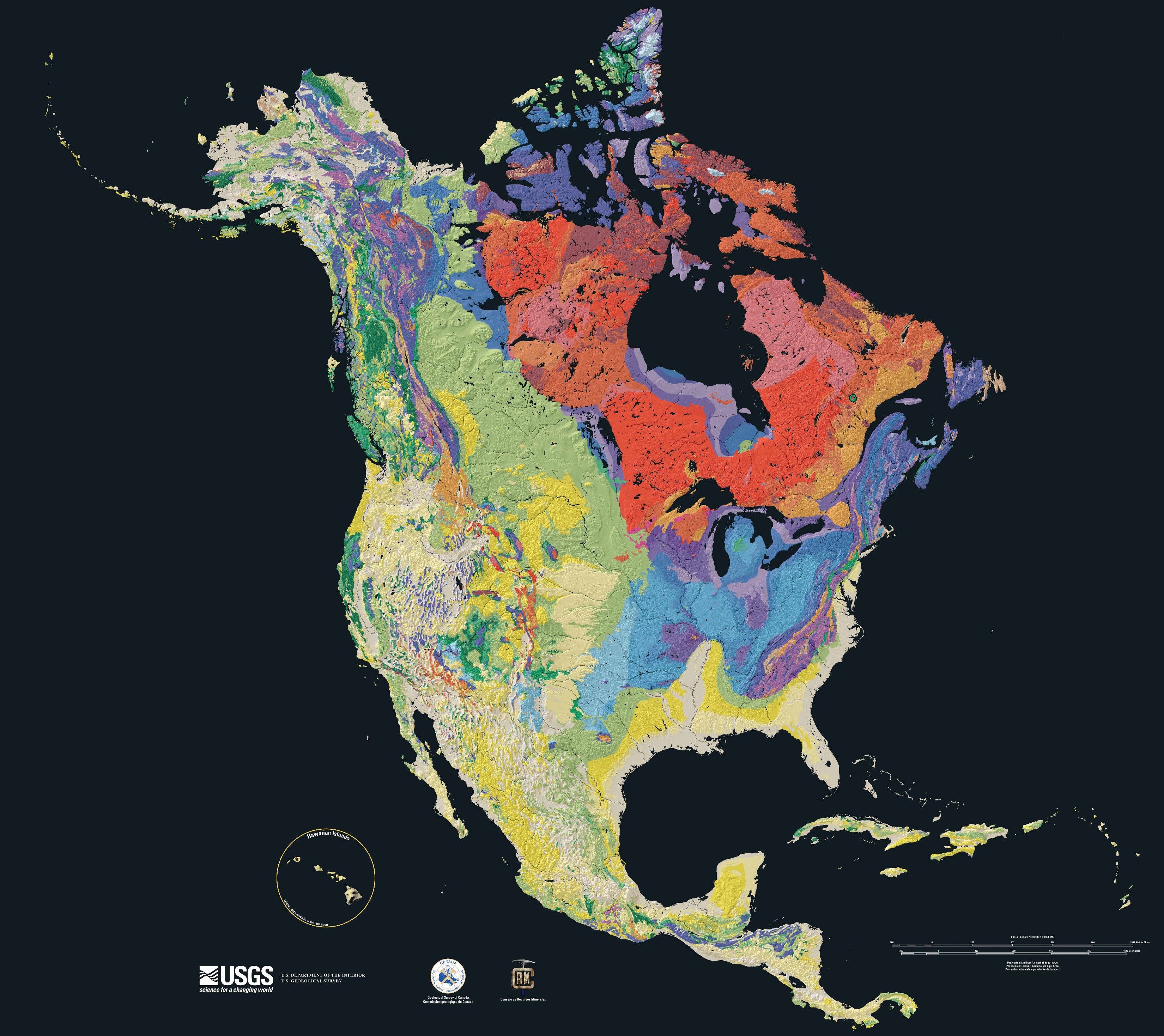
Relief map showing the varying age of bedrock underlying North America.

This cartographic tapestry is woven from a geologic map and a shaded relief image. This combination reveals the geologic history of North America through the interrelation of rock type, topography and time. Regional surface processes as well as continent-scale tectonic events are exposed in the three dimensions of space and the fourth dimension, geologic time.
From most recent to oldest, age is indicated by: yellow, green, blue, red.

The fuchsia U-shape of the Canadian Shield is clearly apparent. The base of ancient mountains and impact craters, this mineral-rich rock is nearly bare due to recent ice ages.

The Canadian Shield is an exposed part of the North American craton, a stable area which extends down the continent along the blue areas, and includes the sweep east of the Rocky Mountains back northward along the pale yellows of the Great Plains, light green across Wyoming and nearly to Alaska.
Rock types
Four maps show the North American distribution of four principal types of rock: sedimentary, volcanic, plutonic and metamorphic rock.


Source

The North America Tapestry of Time and Terrain (1:8,000,000 scale) is a product of the United States Geological Survey in the I-map series (I-2781). This map was prepared in collaboration with the Geological Survey of Canada and the Mexican Consejo Recursos de Minerales[1] archive copy at the Wayback Machine.
Home: http://pubs.usgs.gov/imap/i2781/
Image: http://pubs.usgs.gov/imap/i2781/i2781_c_low.pdf 144 dpi, encoded to 72 dpi JPEG, compressed slightly to fit within Wikipedia 2MB limit.
English Wikipedia, original upload 15 April 2005 by SEWilco
| Public domainPublic domainfalsefalse |
This image is in the public domain in the United States because it only contains materials that originally came from the United States Geological Survey, an agency of the United States Department of the Interior. For more information, see the official USGS copyright policy.
Bahasa Indonesia ∙ català ∙ čeština ∙ Deutsch ∙ eesti ∙ English ∙ español ∙ français ∙ galego ∙ italiano ∙ Nederlands ∙ português ∙ polski ∙ sicilianu ∙ suomi ∙ Tiếng Việt ∙ Türkçe ∙ български ∙ македонски ∙ русский ∙ മലയാളം ∙ 한국어 ∙ 日本語 ∙ 中文 ∙ 中文(简体) ∙ 中文(繁體) ∙ العربية ∙ فارسی ∙ +/− |
| Annotations InfoField | This image is annotated: View the annotations at Commons |
Grönland fehlt / Greenland is missing
Captions
Items portrayed in this file
depicts
image/jpeg
File history
Click on a date/time to view the file as it appeared at that time.
| Date/Time | Thumbnail | Dimensions | User | Comment | |
|---|---|---|---|---|---|
| current | 15:21, 16 September 2005 | | 3,300 × 2,938 (1.66 MB) | Saperaud~commonswiki | Relief map showing the varying age of bedrock underlying North America. thumb|150px|right|Time scale for [[:Image:North america terrain 2003 map.jpg|North America terrain ]] This cartographic t |
File usage
- Geography of North America
- Geologic map
- Geologic mapping of Georgia (U.S. state)
- Geology of North America
- History of Earth
- North America
- Talk:Geology of the United States/Archive 1
- User:Avenue/sandbox
- User:Cyde/Featured pictures
- User:Geothraner
- User:SEWilco
- User:SEWilco/Images
- User:Striver/Pictures
- User talk:Geothraner
- Wikipedia:Featured picture candidates/April-2005
- Wikipedia:Featured picture candidates/North america terrain 2003 map.jpg
- Wikipedia:Featured pictures/Diagrams, drawings, and maps/Maps
- Wikipedia:Featured pictures thumbs/02
- Wikipedia:POTD/June 19, 2005
- Wikipedia:Picture of the day/April 2007
- Wikipedia:Picture of the day/June 19, 2005
- Wikipedia:Picture of the day/June 2005
- Wikipedia:WikiProject Canada/Featured and good content
- Wikipedia:WikiProject United States/Featured pictures
- Wikipedia:WikiProject United States/Quality content
- Wikipedia:WikiProject United States/Recognized content
- Wikipedia:Wikipedia Signpost/2005-05-02/Features and admins
- Wikipedia:Wikipedia Signpost/Single/2005-05-02
- Wikipedia talk:WikiProject Geology/Archive 3
- Template:POTD/2007-04-21
- Portal:Canada/Featured content
- Portal:Canada/Indices
- Portal:Geology
- Portal:Geology/Selected picture
- Portal:Maps/Selected picture
- Portal:Maps/Selected picture/15
- Portal:North America/Selected picture
- Portal:North America/Selected picture/19
- Portal:World
Global file usage
The following other wikis use this file:
- Usage on af.wikipedia.org
- Usage on ar.wikipedia.org
- Usage on arz.wikipedia.org
- Usage on bn.wikipedia.org
- Usage on de.wikipedia.org
- Usage on el.wikipedia.org
- Usage on en.wikiquote.org
- Usage on en.wikiversity.org
- Usage on eu.wikipedia.org
- Usage on fi.wikipedia.org
- Usage on fr.wikipedia.org
- Usage on hu.wikipedia.org
- Usage on ia.wikipedia.org
- Usage on id.wikipedia.org
- Usage on km.wikipedia.org
- Usage on ms.wikipedia.org
- Usage on pl.wikipedia.org
- Usage on pt.wikipedia.org
- Usage on simple.wikipedia.org
- Usage on tr.wikipedia.org
- Usage on uk.wikipedia.org
- Usage on vi.wikipedia.org
- Usage on www.wikidata.org
- Usage on yo.wikipedia.org
Metadata
This file contains additional information, probably added from the digital camera or scanner used to create or digitize it.
If the file has been modified from its original state, some details may not fully reflect the modified file.
| JPEG file comment | Image generated by GNU Ghostscript (device=ppmraw) CREATOR: XV Version 3.10a Rev: 12/29/94 (PNG patch 1.2) Quality = 90, Smoothing = 0 |
|---|