File:North_Pacific_Subtropical_Convergence_Zone.jpg
From Wikipedia, the free encyclopedia
No higher resolution available.
North_Pacific_Subtropical_Convergence_Zone.jpg (400 × 290 pixels, file size: 104 KB, MIME type: image/jpeg)
| This is a file from the Wikimedia Commons. Information from its description page there is shown below. Commons is a freely licensed media file repository. You can help. |
 | This image was uploaded in the JPEG format even though it consists of non-photographic data. This information could be stored more efficiently or accurately in the PNG or SVG format. If possible, please upload a PNG or SVG version of this image without compression artifacts, derived from a non-JPEG source (or with existing artifacts removed). After doing so, please tag the JPEG version with {{Superseded|NewImage.ext}} and remove this tag. This tag should not be applied to photographs or scans. If this image is a diagram or other image suitable for vectorisation, please tag this image with {{Convert to SVG}} instead of {{BadJPEG}}. If not suitable for vectorisation, use {{Convert to PNG}}. For more information, see {{BadJPEG}}. |  |
Summary
| DescriptionNorth Pacific Subtropical Convergence Zone.jpg |
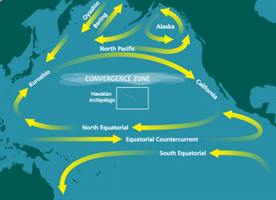
English: Map of the North Pacific Subtropical Convergence Zone (STCZ) within the North Pacific Gyre. Also the location of the Great Pacific Garbage Patch. |
| Date |
Unknown date Unknown date |
| Source | http://marinedebris.noaa.gov/info/patch.html |
| Author | NOAA |
| Permission (Reusing this file) |
Public domain |
| Other versions | Derivative works of this file: North Pacific Subtropical Convergence Zone-es.png |
Licensing
| Public domainPublic domainfalsefalse |
This image is in the public domain because it contains materials that originally came from the U.S. National Oceanic and Atmospheric Administration, taken or made as part of an employee's official duties.
العربية ∙ čeština ∙ Deutsch ∙ Zazaki ∙ English ∙ español ∙ eesti ∙ suomi ∙ français ∙ hrvatski ∙ magyar ∙ italiano ∙ 日本語 ∙ 한국어 ∙ македонски ∙ മലയാളം ∙ Plattdüütsch ∙ Nederlands ∙ polski ∙ português ∙ română ∙ русский ∙ sicilianu ∙ slovenščina ∙ Türkçe ∙ Tiếng Việt ∙ 简体中文 ∙ 繁體中文 ∙ +/− |
| This image was uploaded in the JPEG format even though it consists of non-photographic data. This information could be stored more efficiently or accurately in the PNG or SVG format. If possible, please upload a PNG or SVG version of this image without compression artifacts, derived from a non-JPEG source (or with existing artifacts removed). After doing so, please tag the JPEG version with {{Superseded|NewImage.ext}} and remove this tag. This tag should not be applied to photographs or scans. If this image is a diagram or other image suitable for vectorisation, please tag this image with {{Convert to SVG}} instead of {{BadJPEG}}. If not suitable for vectorisation, use {{Convert to PNG}}. For more information, see {{BadJPEG}}. | |
File history
Click on a date/time to view the file as it appeared at that time.
| Date/Time | Thumbnail | Dimensions | User | Comment | |
|---|---|---|---|---|---|
| current | 05:10, 29 June 2010 | | 400 × 290 (104 KB) | Dcoetzee | Remove watermark reading "WWW.MARINEDEBRIS.NOAA.GOV" |
| 07:41, 18 May 2009 |  | 400 × 290 (107 KB) | Renamed user ixgysjijel | {{Information |Description={{en|1=Map of the North Pacific Subtropical Convergence Zone (STCZ) within the North Pacific Gyre. Also the location of the Great Pacific Garbage Patch.}} |Source=http://marinedebris.noaa.gov/info/patch.html |Author=NOAA |Date= |
File usage
The following pages on the English Wikipedia use this file (pages on other projects are not listed):
- Boundary current
- Ecosystem of the North Pacific Subtropical Gyre
- Great Pacific garbage patch
- High-nutrient, low-chlorophyll regions
- Marine plastic pollution
- Maritime history of California
- North Pacific Gyre
- Thomas Cavendish
- Thomas Cavendish's circumnavigation
- United Nations Ocean Conference
- User:Horn.kali/sandbox
- User:Vanisheduser431890/sandbox
Global file usage
The following other wikis use this file:
- Usage on ar.wikipedia.org
- Usage on ca.wikipedia.org
- Usage on da.wikipedia.org
- Usage on en.wikiversity.org
- Usage on es.wikipedia.org
- Usage on fa.wikipedia.org
- Usage on fr.wikipedia.org
- Usage on he.wikipedia.org
- Usage on id.wikipedia.org
- Usage on ig.wikipedia.org
- Usage on it.wikipedia.org
- Usage on ja.wikipedia.org
- Usage on ko.wikipedia.org
- Usage on krc.wikipedia.org
- Usage on mdf.wikipedia.org
- Usage on nl.wikipedia.org
- Usage on pl.wikipedia.org
- Usage on pt.wikipedia.org
- Usage on ru.wikipedia.org
- Usage on simple.wikipedia.org
- Usage on sl.wikipedia.org
- Usage on sv.wikipedia.org
- Usage on th.wikipedia.org
- Usage on uk.wikipedia.org
- Usage on vi.wikipedia.org
- Usage on www.wikidata.org
- Usage on zh.wikipedia.org
Metadata
This file contains additional information, probably added from the digital camera or scanner used to create or digitize it.
If the file has been modified from its original state, some details may not fully reflect the modified file.
| Short title |
|
|---|---|
| Width | 400 px |
| Height | 290 px |
| Bits per component |
|
| Pixel composition | RGB |
| Orientation | Normal |
| Number of components | 3 |
| Horizontal resolution | 72 dpi |
| Vertical resolution | 72 dpi |
| Software used | Adobe Photoshop CS5 Windows |
| File change date and time | 22:09, 28 June 2010 |
| Exif version | 2.21 |
| Color space | Uncalibrated |
| Date and time of digitizing | 05:25, 28 January 2009 |
| Date metadata was last modified | 15:09, 28 June 2010 |
| Unique ID of original document | uuid:7CA19B9BA3EDDD11B6FFB9BD2CC036AD |
| Copyright status | Copyright status not set |