File:Map_provinces_Netherlands-de.svg
From Wikipedia, the free encyclopedia

Size of this PNG preview of this SVG file: 506 × 600 pixels. Other resolutions: 202 × 240 pixels | 405 × 480 pixels | 648 × 768 pixels | 864 × 1,024 pixels | 1,727 × 2,048 pixels | 743 × 881 pixels.
Original file (SVG file, nominally 743 × 881 pixels, file size: 516 KB)
| This is a file from the Wikimedia Commons. Information from its description page there is shown below. Commons is a freely licensed media file repository. You can help. |
This W3C-unspecified vector image was created with Inkscape .
| This SVG file contains embedded text that can be translated into your language, using any capable SVG editor, text editor or the SVG Translate tool. For more information see: About translating SVG files. |
Summary
| DescriptionMap provinces Netherlands-de.svg |
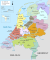
Deutsch: Karte der Niederlande, mit den Provinzen, den Karibischen Niederlanden, den Großstädten, den Flüssen und den Seen. Die deutsche Version.
English: Map of the Netherlands (including the special municipalities of Saba, Saint Eustatius and Bonaire; the Caribbean Netherlands), showing provinces, large cities, rivers and lakes. German Version. |
| Source | Own work |
| Author | Alphathon |
| Other versions |
[edit]
|


.svg)
Licensing
I, the copyright holder of this work, hereby publish it under the following licenses:
This file is licensed under the Creative Commons Attribution-Share Alike 3.0 Unported license.
- You are free:
- to share – to copy, distribute and transmit the work
- to remix – to adapt the work
- Under the following conditions:
- attribution – You must give appropriate credit, provide a link to the license, and indicate if changes were made. You may do so in any reasonable manner, but not in any way that suggests the licensor endorses you or your use.
- share alike – If you remix, transform, or build upon the material, you must distribute your contributions under the same or compatible license as the original.

|
Permission is granted to copy, distribute and/or modify this document under the terms of the GNU Free Documentation License, Version 1.2 or any later version published by the Free Software Foundation; with no Invariant Sections, no Front-Cover Texts, and no Back-Cover Texts. A copy of the license is included in the section entitled GNU Free Documentation License.http://www.gnu.org/copyleft/fdl.htmlGFDLGNU Free Documentation Licensetruetrue |
You may select the license of your choice.
Captions
Add a one-line explanation of what this file represents
Items portrayed in this file
depicts
File history
Click on a date/time to view the file as it appeared at that time.
| Date/Time | Thumbnail | Dimensions | User | Comment | |
|---|---|---|---|---|---|
| current | 21:03, 24 March 2016 | | 743 × 881 (516 KB) | Furfur | Scheldt -> Schelde, Nether Rhein -> Niederrhein, Antwerp -> Antwerpen |
| 14:42, 14 November 2015 |  | 743 × 881 (888 KB) | Timmaexx | Rhine -> Rhein | |
| 08:40, 15 October 2014 |  | 743 × 881 (888 KB) | Bibi Saint-Pol | s/GroßStadt/Großstadt/ | |
| 16:54, 14 October 2014 |  | 743 × 881 (888 KB) | Bibi Saint-Pol | Improve map with conventional colors and markers, using Liberation fonts for optimal Mediawiki rendering | |
| 21:22, 25 July 2012 |  | 743 × 881 (1.34 MB) | Thomas5388 | Meuse -> Maas | |
| 23:15, 10 February 2011 |  | 743 × 881 (1.34 MB) | Alphathon | New version with fixed borders and special municipalities | |
| 11:53, 30 August 2010 |  | 743 × 881 (698 KB) | Alphathon | Fixed error and "Vlissingen" label | |
| 11:48, 30 August 2010 |  | 743 × 881 (697 KB) | Alphathon | Fixed "Schelde" labels | |
| 11:38, 30 August 2010 |  | 743 × 881 (698 KB) | Alphathon | Accidental removal of objects | |
| 11:36, 30 August 2010 |  | 743 × 881 (698 KB) | Alphathon | EN: Made all province shapes representative of actual shape; previously there were hidden sections underneath other provinces |
File usage
No pages on the English Wikipedia use this file (pages on other projects are not listed).
Global file usage
The following other wikis use this file:
- Usage on bar.wikipedia.org
- Usage on de.wikipedia.org
- Usage on de.wikivoyage.org
- Usage on de.wiktionary.org
- Usage on frr.wikipedia.org
- Usage on lb.wikipedia.org
- Usage on nds.wikipedia.org
Metadata
This file contains additional information, probably added from the digital camera or scanner used to create or digitize it.
If the file has been modified from its original state, some details may not fully reflect the modified file.
| Width | 743px |
|---|---|
| Height | 881px |
Retrieved from "https://en.wikipedia.org/wiki/File:Map_provinces_Netherlands-de.svg"