File:Egypt_Topography.png
From Wikipedia, the free encyclopedia
No higher resolution available.
Egypt_Topography.png (384 × 370 pixels, file size: 254 KB, MIME type: image/png)
| This is a file from the Wikimedia Commons. Information from its description page there is shown below. Commons is a freely licensed media file repository. You can help. |
Summary
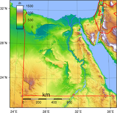
| DescriptionEgypt Topography.png | Topographic map of Egypt. Created with GMT from SRTM data. |
| Date | |
| Source | Own work |
| Author | Sadalmelik |
Licensing
| Public domainPublic domainfalsefalse |
| This work has been released into the public domain by its author, I, Sadalmelik. This applies worldwide. In some countries this may not be legally possible; if so: I, Sadalmelik grants anyone the right to use this work for any purpose, without any conditions, unless such conditions are required by law. |
Captions
Add a one-line explanation of what this file represents
صورة طوبوجرافية لمصر
Items portrayed in this file
depicts
29 June 2007
File history
Click on a date/time to view the file as it appeared at that time.
| Date/Time | Thumbnail | Dimensions | User | Comment | |
|---|---|---|---|---|---|
| current | 23:03, 28 November 2013 | | 384 × 370 (254 KB) | Amrtarek | (Halaib Triangle) |
| 19:42, 29 June 2007 |  | 1,843 × 1,776 (2.9 MB) | Sadalmelik | {{Information |Description=Topographic map of Egypt. Created with GMT from SRTM data. |Source=self-made |Date=June 29, 2007 |Author= Sadalmelik }} Category:Maps of Egypt Category:Topographic maps of Africa |
File usage
The following pages on the English Wikipedia use this file (pages on other projects are not listed):
Global file usage
The following other wikis use this file:
- Usage on ar.wikipedia.org
- Usage on arz.wikipedia.org
- Usage on avk.wikipedia.org
- Usage on ba.wikipedia.org
- Usage on bn.wikipedia.org
- Usage on cs.wikipedia.org
- Usage on cy.wikipedia.org
- Usage on da.wikipedia.org
- Usage on de.wikipedia.org
- Usage on el.wikipedia.org
- Usage on es.wikipedia.org
- Usage on et.wikipedia.org
- Usage on fa.wikipedia.org
- Usage on fr.wikipedia.org
- Usage on he.wikipedia.org
- Usage on hu.wikipedia.org
- Usage on io.wikipedia.org
- Usage on is.wikipedia.org
- Usage on it.wikipedia.org
- Usage on ja.wikipedia.org
- Usage on ka.wikipedia.org
- Usage on mdf.wikipedia.org
- Usage on ms.wikipedia.org
- Usage on no.wikipedia.org
- Usage on ro.wikipedia.org
- Usage on ru.wikipedia.org
- Usage on si.wikipedia.org
- Usage on sk.wikipedia.org
- Usage on sl.wikipedia.org
- Usage on szy.wikipedia.org
- Usage on trv.wikipedia.org
- Usage on tr.wikipedia.org
- Usage on tum.wikipedia.org
- Usage on uk.wikipedia.org
- Usage on vec.wikipedia.org
- Usage on vep.wikipedia.org
- Usage on www.wikidata.org
- Usage on xmf.wikipedia.org
- Usage on zh.wikipedia.org
Metadata
This file contains additional information, probably added from the digital camera or scanner used to create or digitize it.
If the file has been modified from its original state, some details may not fully reflect the modified file.
| Horizontal resolution | 105.11 dpc |
|---|---|
| Vertical resolution | 105.11 dpc |
Retrieved from "https://en.wikipedia.org/wiki/File:Egypt_Topography.png"