File:Ce-map.png
From Wikipedia, the free encyclopedia
Ceylan-map.png (325 × 349 pixels, file size: 9 KB, MIME type: image/png)
| This is a file from the Wikimedia Commons. Information from its description page there is shown below. Commons is a freely licensed media file repository. You can help. |

|
This map image could be re-created using vector graphics as an SVG file. This has several advantages; see Commons:Media for cleanup for more information. If an SVG form of this image is available, please upload it and afterwards replace this template with
{{vector version available|new image name}}.
It is recommended to name the SVG file “Ceylan-map.svg”—then the template Vector version available (or Vva) does not need the new image name parameter. |
| DescriptionCeylan-map.png |
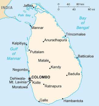
English: Map of Sri Lanka from the 2004 CIA Factbook (internet version) |
||||
| Date | |||||
| Source | 2004 CIA Factbook (internet version) | ||||
| Author | CIA | ||||
| Permission (Reusing this file) |
|
||||
| Other versions |
[edit]
|


.png)


| This file is an original and may be obsolete for general use, but is kept for historical or archival use. As such, it should not be modified or deleted except to correct upload or technical errors. Any modified versions or replacements of this image should be uploaded with a different file name. A version of this file more suitable for general use can be found at File:Sri Lanka-CIA WFB Map.png. Information about this file: 2004 version العربيَّة ∙ čeština ∙ Deutsch ∙ English ∙ español ∙ فارسی ∙ français ∙ magyar ∙ italiano ∙ 日本語 ∙ Lëtzebuergesch ∙ македонски ∙ മലയാളം ∙ Nederlands ∙ português ∙ русский ∙ slovenščina ∙ svenska ∙ 简体中文 ∙ 繁體中文 ∙ 正體中文(臺灣) ∙ +/− |
Captions
Items portrayed in this file
depicts
2004
image/png
ebb21446ec6e94e10caedbc05732d4a5d657c2c1
8,708 byte
349 pixel
325 pixel
File history
Click on a date/time to view the file as it appeared at that time.
| Date/Time | Thumbnail | Dimensions | User | Comment | |
|---|---|---|---|---|---|
| current | 18:40, 12 March 2022 | | 325 × 349 (9 KB) | Lojwe | Cropped 2 % horizontally, 2 % vertically using CropTool with precise mode. |
| 23:32, 14 December 2004 |  | 330 × 355 (8 KB) | Mschlindwein | Ceylan Map |
File usage
Global file usage
The following other wikis use this file:
- Usage on af.wikipedia.org
- Usage on als.wikipedia.org
- Usage on ang.wikipedia.org
- Usage on ast.wikipedia.org
- Usage on az.wikipedia.org
- Usage on bar.wikipedia.org
- Usage on be-tarask.wikipedia.org
- Usage on bg.wiktionary.org
- Usage on bn.wikipedia.org
- Usage on ca.wikipedia.org
- Usage on cs.wikipedia.org
- Usage on de.wikibooks.org
- Usage on de.wikinews.org
- Usage on el.wikipedia.org
- Usage on en.wikinews.org
- Usage on en.wiktionary.org
- Usage on fa.wikipedia.org
- Usage on fi.wikipedia.org
- Usage on fi.wikivoyage.org
- Usage on ga.wikipedia.org
- Usage on gd.wikipedia.org
- Usage on gl.wikipedia.org
- Usage on io.wikipedia.org
- Usage on it.wikipedia.org
- Usage on it.wikinews.org
- Usage on jv.wikipedia.org
- Usage on ka.wikipedia.org
- Usage on km.wikipedia.org
- Usage on ko.wikipedia.org
- Usage on ml.wikipedia.org
- Usage on mn.wikipedia.org
- Usage on ne.wikipedia.org
- Usage on nl.wikipedia.org
- Usage on pcd.wikipedia.org
- Usage on pl.wikivoyage.org
- Usage on pt.wikipedia.org
- Usage on ru.wikipedia.org
- Usage on scn.wikipedia.org
- Usage on si.wikipedia.org
- Usage on sl.wikipedia.org
- Usage on tr.wiktionary.org
View more global usage of this file.
Metadata
This file contains additional information, probably added from the digital camera or scanner used to create or digitize it.
If the file has been modified from its original state, some details may not fully reflect the modified file.
| File change date and time | 18:40, 12 March 2022 |
|---|---|
| Software used |