Fitxer:Tamis_banat1718_1739.png
From Wikipedia, the free encyclopedia
Mida d'aquesta previsualització: 465 × 599 píxels. Altres resolucions: 186 × 240 píxels | 373 × 480 píxels | 1.008 × 1.298 píxels.
Fitxer original (1.008 × 1.298 píxels, mida del fitxer: 146 Ko, tipus MIME: image/png)
| Aquest fitxer i la informació mostrada a continuació provenen del dipòsit multimèdia lliure Wikimedia Commons. |
Resum
| DescripcióTamis banat1718 1739.png |
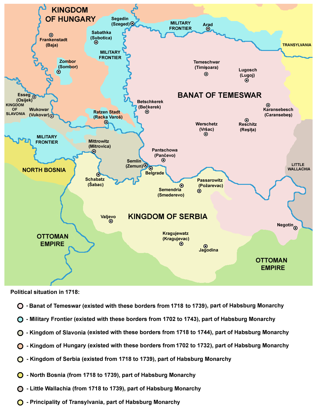
English: Map of the Banat of Temeswar, Kingdom of Serbia and Military Frontier in 1718. Serbian: Мапа Тамишког Баната, Краљевине Србије и војне границе 1718. године. |
| Data | |
| Font | Treball propi |
| Autor | PANONIAN |
Llicència
| Public domainPublic domainfalsefalse |
| Jo, el titular del copyright d'aquesta obra, l'allibero al domini públic. Això s'aplica a tot el món. En alguns països això pot no ser legalment possible, en tal cas: Jo faig concessió a tothom del dret d'usar aquesta obra per a qualsevol propòsit, sense cap condició llevat d'aquelles requerides per la llei. |
References
- The Times History of Europe, Times Books, London, 2002.
- Istorijski atlas, Zavod za udžbenike i nastavna sredstva - Zavod za kartografiju "Geokarta", Beograd, 1999.
- Školski istorijski atlas, Zavod za izdavanje udžbenika Socijalističke Republike Srbije, Beograd, 1970.
- Denis Šehić - Demir Šehić, Istorijski atlas Sveta, Beograd, 2007.
- Milan Tutorov, Banatska rapsodija - istorika Zrenjanina i Banata, Novi Sad, 2001.
- Peter Rokai - Zoltan Đere - Tibor Pal - Aleksandar Kasaš, Istorija Mađara, Beograd, 2002.
- Dr Dušan J. Popović, Srbi u Vojvodini, knjiga 2, Novi Sad, 1990.
- Dr Milenko Palić, Srbi u Mađarskoj - Ugarskoj do 1918, Novi Sad, 1995.
- J. H. Šviker, Politička istorija Srba u Ugarskoj, Novi Sad - Beograd, 1998.
- Fridrih Vilhelm fon Taube, Istorijski i geografski opis Kraljevine Slavonije i Vojvodstva Srema, Novi Sad, 1998.
- Miodrag Milin, Vekovima zajedno (Iz istorije srpsko-rumunskih odnosa), Temišvar, 1995.
- Suzana Milovanović, Potiska i pomoriška vojna granica (1702-1751), Novi Sad, 2003.
- Dimitrije Boarov, Politička istorija Vojvodine, Novi Sad, 2001.
- Drago Njegovan, Prisajedinjenje Vojvodine Srbiji, Novi Sad, 2004.
- Olga Zirojević, Srbija pod turskom vlašću 1459-1804, Beograd, 2007.
- Vladimir Ćorović, Ilustrovana istorija Srba, knjiga četvrta, Beograd, 2006.
- http://www.conflicts.rem33.com/images/Ungarn/OESTEREICH%20ENTWICKLUNG.jpg
- http://terkepek.adatbank.transindex.ro/kepek/netre/51.gif
- http://upload.wikimedia.org/wikipedia/commons/8/8e/Growth_of_Habsburg_territories.jpg
- http://images.nationmaster.com/images/motw/historical/ward_1912/south_east_europe_1648.jpg archive copy at the Wayback Machine
- http://dic.academic.ru/pictures/dewiki/80/Passarowitz_1718.JPG
- http://upload.wikimedia.org/wikipedia/commons/7/7c/Temeswarer_Banat.JPG
- http://gettysburg.cdmhost.com/cdm4/item_viewer.php?CISOROOT=/p4016coll7&CISOPTR=429&CISOBOX=1&REC=2
- http://www.garwood-voigt.com/catalogues/H22365SclavoniaeHomann.jpg
Llegendes
Afegeix una explicació d'una línia del que representa aquest fitxer
Elements representats en aquest fitxer
representa l'entitat
Algun valor sense element de Wikidata
image/png
Historial del fitxer
Cliqueu una data/hora per veure el fitxer tal com era aleshores.
| Data/hora | Miniatura | Dimensions | Usuari/a | Comentari | |
|---|---|---|---|---|---|
| actual | 00:47, 24 juny 2014 | | 1.008 × 1.298 (146 Ko) | PANONIAN | aesthetics |
| 13:07, 23 juny 2014 |  | 1.008 × 1.298 (146 Ko) | PANONIAN | aesthetics | |
| 11:12, 12 set 2013 |  | 1.008 × 1.298 (149 Ko) | PANONIAN | correction | |
| 20:34, 13 feb 2013 |  | 1.008 × 1.298 (149 Ko) | PANONIAN | correction | |
| 15:15, 22 des 2012 |  | 1.008 × 1.298 (149 Ko) | PANONIAN | minor aesthetical improvement | |
| 19:07, 30 set 2011 |  | 998 × 1.294 (149 Ko) | PANONIAN | correction | |
| 17:47, 29 set 2011 |  | 998 × 1.294 (149 Ko) | PANONIAN | correction | |
| 16:07, 29 set 2011 |  | 998 × 1.294 (149 Ko) | PANONIAN | some corrections and improvements | |
| 21:52, 21 des 2009 |  | 998 × 1.206 (144 Ko) | PANONIAN | {{Information |Description={{en|1=Map of the Banat of Temeswar and Military Frontier in 1718}} |Source={{own}} |Author=PANONIAN |Date= |Permission= |other_versions= }} |
Ús del fitxer
Les 3 pàgines següents utilitzen aquest fitxer:
Ús global del fitxer
Utilització d'aquest fitxer en altres wikis:
- Utilització a ar.wikipedia.org
- Utilització a az.wikipedia.org
- Utilització a be-tarask.wikipedia.org
- Utilització a be.wikipedia.org
- Utilització a bg.wikipedia.org
- Utilització a bs.wikipedia.org
- Utilització a cs.wikipedia.org
- Utilització a da.wikipedia.org
- Utilització a de.wikipedia.org
- Utilització a el.wikipedia.org
- Utilització a en.wikipedia.org
- Utilització a es.wikipedia.org
- Utilització a eu.wikipedia.org
- Utilització a fa.wikipedia.org
- Utilització a fr.wikipedia.org
- Utilització a gl.wikipedia.org
- Utilització a he.wikipedia.org
- Utilització a hr.wikipedia.org
- Utilització a it.wikipedia.org
- Utilització a ko.wikipedia.org
- Utilització a mk.wikipedia.org
- Utilització a mr.wikipedia.org
- Utilització a nl.wikipedia.org
- Utilització a nn.wikipedia.org
- Utilització a no.wikipedia.org
- Utilització a pl.wikipedia.org
Vegeu més usos globals d'aquest fitxer.