Fitxer:Gr-map.png
From Wikipedia, the free encyclopedia
Gr-map.png (326 × 350 píxels, mida del fitxer: 30 Ko, tipus MIME: image/png)
| Aquest fitxer i la informació mostrada a continuació provenen del dipòsit multimèdia lliure Wikimedia Commons. |
| DescripcióGr-map.png |
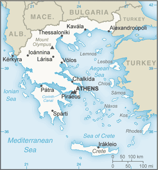
Map of Greece, with English text, from CIA World Factbook |
||||
| Data | 22 d'agost de 2013 (PAGE LAST UPDATED ON AUGUST 22, 2013) | ||||
| Font | https://www.cia.gov/library/publications/the-world-factbook/geos/gr.html | ||||
| Autor | The World Factbook 2013-14. Washington, DC: Central Intelligence Agency, 2013 . | ||||
| Permís (Com reutilitzar aquest fitxer) |
|

Llegendes
Elements representats en aquest fitxer
representa l'entitat
22 ago 2013
Historial del fitxer
Cliqueu una data/hora per veure el fitxer tal com era aleshores.
| Data/hora | Miniatura | Dimensions | Usuari/a | Comentari | |
|---|---|---|---|---|---|
| actual | 19:57, 31 ago 2013 | | 326 × 350 (30 Ko) | Hedwig in Washington | |
| 18:35, 31 ago 2013 |  | 326 × 350 (14 Ko) | Makedonski Mak | Reverted to version as of 22:50, 29 August 2013 | |
| 18:35, 31 ago 2013 |  | 326 × 350 (14 Ko) | Makedonski Mak | Reverted to version as of 22:50, 29 August 2013 | |
| 16:00, 31 ago 2013 |  | 326 × 350 (41 Ko) | Tuvalkin | Needless change on a UN map: Reverted to version as of 11:16, 29 August 2013 | |
| 00:50, 30 ago 2013 |  | 326 × 350 (14 Ko) | Makedonski Mak | Reverted to version as of 20:29, 28 August 2013 | |
| 14:50, 29 ago 2013 |  | 326 × 350 (14 Ko) | MacedonianMk | Reverted to version as of 20:29, 28 August 2013 | |
| 13:16, 29 ago 2013 |  | 326 × 350 (41 Ko) | MacedonianBoy | Reverted to version as of 20:27, 28 August 2013 | |
| 22:29, 28 ago 2013 |  | 326 × 350 (14 Ko) | MacedonianMk | Reverted to version as of 17:26, 28 August 2013 | |
| 22:27, 28 ago 2013 |  | 326 × 350 (41 Ko) | MacedonianBoy | Reverted to version as of 09:51, 28 August 2013 | |
| 19:26, 28 ago 2013 |  | 326 × 350 (14 Ko) | Ο Μέγας Αλέξανδρος | Reverted to version as of 17:26, 27 August 2013 |
Ús del fitxer
La pàgina següent utilitza aquest fitxer:
Ús global del fitxer
Utilització d'aquest fitxer en altres wikis:
- Utilització a als.wikipedia.org
- Utilització a be-tarask.wikipedia.org
- Utilització a da.wikipedia.org
- Utilització a de.wikipedia.org
- Utilització a dsb.wikipedia.org
- Utilització a el.wikipedia.org
- Utilització a en.wikipedia.org
- User:Jnestorius/Regions with significant island landmass
- Wikipedia:Requests for arbitration/Coolcat, Davenbelle and Stereotek/Evidence/Coolcat
- Talk:Europe/Archive 4
- Wikipedia:British Isles Terminology task force/Channel Islands
- Wikipedia:Graphics Lab/Map workshop/Archive/May 2010
- Category:Populated places in Greece
- User:Morriswa/My OCONUS travel
- Utilització a en.wikinews.org
- Utilització a eo.wikipedia.org
- Utilització a es.wikipedia.org
- Utilització a es.wikivoyage.org
- Utilització a eu.wikipedia.org
- Utilització a fa.wikipedia.org
- Utilització a fr.wikipedia.org
- Utilització a gag.wikipedia.org
- Utilització a hr.wiktionary.org
- Utilització a id.wikipedia.org
- Utilització a incubator.wikimedia.org
- Utilització a it.wikipedia.org
- Utilització a it.wiktionary.org
- Utilització a ja.wikipedia.org
- Utilització a jv.wikipedia.org
- Utilització a ko.wikipedia.org
- Utilització a lfn.wikipedia.org
- Utilització a lt.wikipedia.org
- Utilització a lt.wiktionary.org
- Utilització a mk.wikipedia.org
- Utilització a mn.wikipedia.org
- Utilització a mr.wikipedia.org
- Utilització a nl.wikipedia.org
Vegeu més usos globals d'aquest fitxer.
Metadades
Aquest fitxer conté informació addicional, probablement afegida per la càmera digital o l'escàner utilitzat per a crear-lo o digitalitzar-lo. Si s'ha modificat posteriorment, alguns detalls poden no reflectir les dades reals del fitxer modificat.
| Resolució horitzontal | 37,79 ppc |
|---|---|
| Resolució vertical | 37,79 ppc |
| Programari utilitzat |
|