File:PBW_March_1919.png
From Wikipedia, the free encyclopedia
পূর্ণ রেজোলিউশন (২,০০০ × ১,৫৩৪ পিক্সেল, ফাইলের আকার: ৩৪৭ কিলোবাইট, এমআইএমই ধরন: image/png)
| এই ফাইলটি উইকিমিডিয়া কমন্স থেকে নেওয়া। সেখানের বর্ণনা পাতার বিস্তারিত নিম্নে দেখানো হলো। (সম্পাদনা)
|
সারাংশ
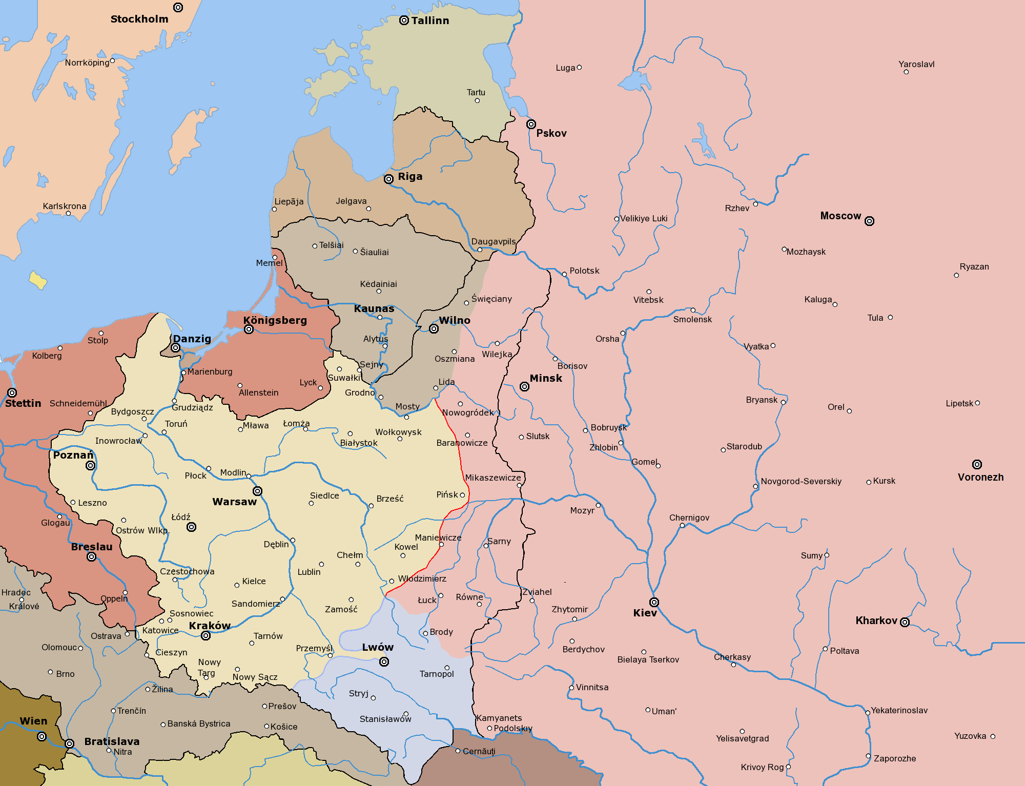
Post-war borders from 1920s marked with black
Since the legal status of the above comment has been questioned, I hereby grant anyone the right to treat it as either a standard copyright notice, invariant section, legal statement, legal advice, friendly suggestion or a mere comment, depending on his or hers own choice. |
|

Other versions


এই ফাইলের উপজাত কর্মসমূহ: PBW March 1919.svg
The following is a list of maps created by Halibutt and uploaded to commons, as well as their present and projected derivatives.
| Parent Image | Image | Description | |||||||||||
|---|---|---|---|---|---|---|---|---|---|---|---|---|---|
| Maps by Halibutt | |||||||||||||
| Image:Rzeczpospolita.png | Image:Rzeczpospolita.png | The Republic in 17th and 18th century | |||||||||||
| Image:Rzeczpospolita 1600.png | The Republic after the Treaty of Dywilino | ||||||||||||
| Image:Rzeczpospolita voivodships.png | Voivodships of The Republic | ||||||||||||
| Image:Rzeczpospolita_Potop.png | The Republic during The Deluge and Chmielnicki Uprising, with major battles of the era marked | ||||||||||||
| Magnates and their lands and domains | |||||||||||||
| 1st • 2nd • 3rd | Partitions of Poland | ||||||||||||
| War of the constitution | |||||||||||||
| Image:Rzeczpospolita.xcf | SOURCE FILE - GIMP format | ||||||||||||
| Image:Poland 1939.png | Image:Poland 1939.png | Poland in 1939 | |||||||||||
| Image:Dywizje wrzesien 1.png | Order of Battle on September 1st, during the Polish Defence War of 1939 | ||||||||||||
| Image:Poland 1939.xcf | SOURCE FILE - GIMP format | ||||||||||||
| Image:Polska kontur bialy.png | Image:Polska kontur bialy.png | Contour map of Poland AD 1999, for use with various locator maps | |||||||||||
| Image:Rzeczpospolita 1923.png | Image:Rzeczpospolita 1923.png | Map of Poland 1918-1939, currently under development | |||||||||||
| Image:PBW March 1919.png | Polish-Bolshevik War - fronts in March of 1919 | ||||||||||||
| Image:PBW December 1919.png | Polish-Bolshevik War - fronts in December of 1919 | ||||||||||||
| Image:PBW June 1920.png | Polish-Bolshevik War - fronts in July of 1920 | ||||||||||||
| Image:PBW August 1920.png | Polish-Bolshevik War - fronts in August of 1920 | ||||||||||||
| Polish Defence War of 1939 | |||||||||||||
| Polish areas annexed by Germany, Lithuania, Slovakia and the Soviet Union | |||||||||||||
| German concentration camps in Poland | |||||||||||||
| Curzon line | |||||||||||||
| Major battles of the Polish-Bolshevik War | |||||||||||||
| names • no names | Polish/Czechoslovak/Lithuanian/German/Ukrainian claims in 1920's | ||||||||||||
| Image:Rzeczpospolita Central Lithuania.png | Central Lithuania | ||||||||||||
| Image:Rzeczpospolita Lithuania claims.png | Central Lithuania as compared with other Lithuanian claims | ||||||||||||
| Image:Rzeczpospolita 1789-1920.png | Post-1922 borders compared with the territory of Poland before the partitions | ||||||||||||
| Warsaw Uprising and the Operation Tempest | |||||||||||||
| Poland partitioned between the Soviets and the Germans | |||||||||||||
| Image:Rzeczpospolita 1939 Polish divisions.png | Polish divisions on September 1, 1939 | ||||||||||||
| Home Army inspectorates | |||||||||||||
| Image:Rzeczpospolita 1922.xcf | SOURCE FILE - GIMP format | ||||||||||||
| Image:Rzeczpospolita 1937.svg | Vector version!!!! | layered version available on request | |||||||||||
ক্যাপশন
এই ফাইলে চিত্রিত আইটেমগুলি
যা চিত্রিত করে
ফাইলের ইতিহাস
যেকোনো তারিখ/সময়ে ক্লিক করে দেখুন ফাইলটি তখন কী অবস্থায় ছিল।
| তারিখ/সময় | সংক্ষেপচিত্র | মাত্রা | ব্যবহারকারী | মন্তব্য | |
|---|---|---|---|---|---|
| বর্তমান | ২০:৪৮, ৩ নভেম্বর ২০১৯ | | ২,০০০ × ১,৫৩৪ (৩৪৭ কিলোবাইট) | Claude Zygiel | Lituanian hold march 19 |
| ১৯:১৩, ২৫ মার্চ ২০১৭ |  | ২,০০০ × ১,৫৩৪ (৩৪৩ কিলোবাইট) | Bogomolov.PL | corrected Volgograd >>> Voronezh | |
| ১৪:২৩, ২৪ ফেব্রুয়ারি ২০১০ |  | ২,০০০ × ১,৫৩৪ (২৮৯ কিলোবাইট) | Dcoetzee | Remove watermark, pngcrush | |
| ২২:৩১, ৮ এপ্রিল ২০০৫ |  | ২,০০০ × ১,৫৩৪ (৪৫৬ কিলোবাইট) | Halibutt | ||
| ১৫:৫০, ৮ এপ্রিল ২০০৫ |  | ২,০০০ × ১,৫৩৪ (৩৪৬ কিলোবাইট) | Halibutt | Frontlines of the Polish-Bolshevik War in March of 1919<br> Post-war borders marked with black<br> Map prepared by Halibutt in GIMP.<br> {{User:Halibutt/GFDL}}<br>{{User:Halibutt/maps}} |
সংযোগসমূহ
এই ফাইল ব্যবহার করে এমন কোনো পাতা নেই।
ফাইলের বৈশ্বিক ব্যবহার
নিচের অন্যান্য উইকিগুলো এই ফাইলটি ব্যবহার করে:
- ar.wikipedia.org-এ ব্যবহার
- az.wikipedia.org-এ ব্যবহার
- ba.wikipedia.org-এ ব্যবহার
- be-tarask.wikipedia.org-এ ব্যবহার
- be.wikipedia.org-এ ব্যবহার
- br.wikipedia.org-এ ব্যবহার
- ca.wikipedia.org-এ ব্যবহার
- cs.wikipedia.org-এ ব্যবহার
- cv.wikipedia.org-এ ব্যবহার
- da.wikipedia.org-এ ব্যবহার
- de.wikipedia.org-এ ব্যবহার
- en.wikipedia.org-এ ব্যবহার
- eo.wikipedia.org-এ ব্যবহার
- es.wikipedia.org-এ ব্যবহার
- et.wikipedia.org-এ ব্যবহার
- fa.wikipedia.org-এ ব্যবহার
- fi.wikipedia.org-এ ব্যবহার
- fr.wikipedia.org-এ ব্যবহার
- he.wikipedia.org-এ ব্যবহার
- hu.wikipedia.org-এ ব্যবহার
- id.wikipedia.org-এ ব্যবহার
- it.wikipedia.org-এ ব্যবহার
- ja.wikipedia.org-এ ব্যবহার
- ka.wikipedia.org-এ ব্যবহার
- lt.wikipedia.org-এ ব্যবহার
- lv.wikipedia.org-এ ব্যবহার
- nl.wikipedia.org-এ ব্যবহার
এই ফাইলের অন্যান্য বৈশ্বিক ব্যবহার দেখুন।
অধি-উপাত্ত
এই ফাইলে অতিরিক্ত কিছু তথ্য আছে। সম্ভবত যে ডিজিটাল ক্যামেরা বা স্ক্যানারের মাধ্যমে এটি তৈরি বা ডিজিটায়িত করা হয়েছিল, সেটি কর্তৃক তথ্যগুলি যুক্ত হয়েছে। যদি ফাইলটি তার আদি অবস্থা থেকে পরিবর্তিত হয়ে থাকে, কিছু কিছু বিবরণ পরিবর্তিত ফাইলটির জন্য প্রযোজ্য না-ও হতে পারে।
| অনুভূমিক রেজোলিউশন | ২৮.৩৫ dpc |
|---|---|
| উল্লম্ব রেজোলিউশন | ২৮.৩৫ dpc |