ملف:Tianjin,_China_ESA15420167.jpeg
From Wikipedia, the free encyclopedia

الصوره الاصليه (1,920 × 1,363 بكسل حجم الفايل: 4.38 ميجابايت، نوع MIME: image/jpeg)
الملف دا من ويكيميديا كومنز و ممكن تستعمله المشاريع التانيه. الوصف بتاعه صفحة وصف الملف هناك معروض تحت..
الخلاصة
| وصفTianjin, China ESA15420167.jpeg |
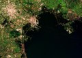
English: The Chinese city of Tianjin is captured in this Sentinel-1A radar image created by combining three scans over several months. The city sits to the west of the Bohai Bay within the Bohai Gulf, off of the Yellow Sea. With a population of over 14 million people, this megacity is among China’s five largest. Urban areas are home to over half of the world’s population, and are rapidly changing environments. As more people move from rural areas to cities, this growth needs to be monitored to help it proceed on a sustainable basis. High-resolution satellite data provide essential information for city planning and for the sustainable development of urban regions. Radar in particular can be used to monitor slight ground movements down to a few millimetres – valuable information for urban planners and for risk assessment. Zooming in on the upper right, we can see different colours in the geometric agricultural fields, showing changes between the three acquisitions (22 October 2014, 14 January 2015 and 7 February 2015) that make up this image. In this area, the black shapes show divided areas covered in water, which are possibly shrimp or fish farms. Bohai Bay was traditionally home to the country’s richest fisheries, but pollution, overfishing and land reclamation has diminished this economic activity. Farther south, we can see numerous dots in the water – radar reflections from the boats coming to and from the Port of Tianjin. This massive maritime gateway handles hundreds of millions of tonnes of cargo each year, and is the largest in northern China. On the central-left side of the image, the black and bright green areas are water reservoirs. The upcoming Sentinel-2 mission – set for launch on 22 June – will be used to support the sustainable management of water resources by providing measurements of water quality and detecting changes. This image is also featured on the Earth from Space video programme. |
| تاريخ | 5 يونيه 2015 (تاريخ الرفع) |
| مصدر | Tianjin, China |
| مؤلف | European Space Agency |
| إصدارات أخرى |
|
| Activity InfoField | Observing the Earth |
| Keyword InfoField | City Urban areas Radar Images |
| Location InfoField | China |
| Mission InfoField | Sentinel-1 |
| Set InfoField | Earth observation image of the week |
| System InfoField | Copernicus |
الترخيص

|
This image contains data from a satellite in the Copernicus Programme, such as Sentinel-1, Sentinel-2 or Sentinel-3. Attribution is required when using this image.
نسبه ل: Contains modified Copernicus Sentinel data 2014/2015
Attribution
The use of Copernicus Sentinel Data is regulated under EU law (Commission Delegated Regulation (EU) No 1159/2013 and Regulation (EU) No 377/2014). Relevant excerpts:
Free access shall be given to GMES dedicated data [...] made available through GMES dissemination platforms [...].
Access to GMES dedicated data [...] shall be given for the purpose of the following use in so far as it is lawful:
GMES dedicated data [...] may be used worldwide without limitations in time.
GMES dedicated data and GMES service information are provided to users without any express or implied warranty, including as regards quality and suitability for any purpose. |
Attribution
This media was created by the European Space Agency (ESA).
Where expressly so stated, images or videos are covered by the Creative Commons Attribution-ShareAlike 3.0 IGO (CC BY-SA 3.0 IGO) licence, ESA being an Intergovernmental Organisation (IGO), as defined by the CC BY-SA 3.0 IGO licence. The user is allowed under the terms and conditions of the CC BY-SA 3.0 IGO license to Reproduce, Distribute and Publicly Perform the ESA images and videos released under CC BY-SA 3.0 IGO licence and the Adaptations thereof, without further explicit permission being necessary, for as long as the user complies with the conditions and restrictions set forth in the CC BY-SA 3.0 IGO licence, these including that:
See the ESA Creative Commons copyright notice for complete information, and this article for additional details.
|
 | |
هذا الملف مرخص تحت ترخيص المشاع الإبداعي النسبة-الترخيص بالمثل 3.0 IGO. نسبه ل: ESA, CC BY-SA IGO 3.0
| ||
الشروحات
العناصر المصورة في هذا الملف
يُصوِّر العربية
الرخصة العربية
نوع الوسائط العربية
image/jpeg
تاريخ الفايل
اضغط على الساعه/التاريخ علشان تشوف الفايل زى ما كان فى الوقت ده.
| الساعه / التاريخ | صورة صغيرة | ابعاد | يوزر | تعليق | |
|---|---|---|---|---|---|
| دلوقتي | 21:08، 11 يونيه 2020 | | 1,920 × 1,363 (4.38 ميجابايت) | OptimusPrimeBot | #Spacemedia - Upload of https://www.esa.int/var/esa/storage/images/esa_multimedia/images/2015/06/tianjin_china/15420158-1-eng-GB/Tianjin_China.jpg via Commons:Spacemedia |
استخدام الفايل
ال1 صفحة دى فيها وصله للفايل ده:
استخدام الملف العام
الويكيات التانيه دى بتستخدم الفايل ده:
- الاستخدام ف ar.wikipedia.org
- الاستخدام ف ast.wikipedia.org
- الاستخدام ف bg.wikipedia.org
- الاستخدام ف br.wikipedia.org
- الاستخدام ف ca.wikipedia.org
- الاستخدام ف ce.wikipedia.org
- الاستخدام ف cy.wikipedia.org
- الاستخدام ف da.wikipedia.org
- الاستخدام ف de.wikivoyage.org
- الاستخدام ف el.wikipedia.org
- الاستخدام ف en.wikivoyage.org
- الاستخدام ف fr.wikipedia.org
- الاستخدام ف fr.wikivoyage.org
- الاستخدام ف ga.wikipedia.org
- الاستخدام ف gl.wikipedia.org
- الاستخدام ف ha.wikipedia.org
- الاستخدام ف he.wikivoyage.org
- الاستخدام ف hy.wikipedia.org
- الاستخدام ف ia.wikipedia.org
- الاستخدام ف it.wikivoyage.org
- الاستخدام ف ja.wikivoyage.org
- الاستخدام ف mhr.wikipedia.org
- الاستخدام ف no.wikipedia.org
- الاستخدام ف os.wikipedia.org
- الاستخدام ف ru.wikinews.org
- الاستخدام ف sr.wikipedia.org
- الاستخدام ف vec.wikipedia.org
- الاستخدام ف www.wikidata.org
بيانات ميتا
الملف ده فيه معلومات إضافيه، غالبا ما تكون أضيفت من الديجيتال كاميرا أو السكانر ح الضوئى المستخدم فى نقل الملف للكومبيوتر.
إذا كان الملف اتعدل عن حالته الأصلية، فبعض التفاصيل مش ها تعبر عن الملف المعدل.
| المعرف الفريد للمستند الأصلي | xmp.did:5C165E74B8C1E411A33CB9FA603E653E |
|---|---|
| البرمجيات المستخدمة | Adobe Photoshop CS4 Windows |