ስዕል:Amarnamap.png
From Wikipedia, the free encyclopedia
Size of this preview: 772 × 599 pixels. Other resolutions: 309 × 240 pixels | 619 × 480 pixels | 782 × 607 pixels.
ዋና ፋይል (782 × 607 ፒክስል፤ መጠን፦ 743 KB፤ የMIME ዓይነት፦ image/png)
ይህ ፋይል ከWikimedia Commons የተቀሰመ ነው እና በሌላ ዊኪ ላይ ሊጠቅም ይችላል። በhttps://commons.wikimedia.org/wiki/File:Amarnamap.png ላይ የሚገኘው የፋይሉ መግለጫ ከዚህ በታች ቀርቧል።
ማጠቃለያ
| ማጠቃለያAmarnamap.png |
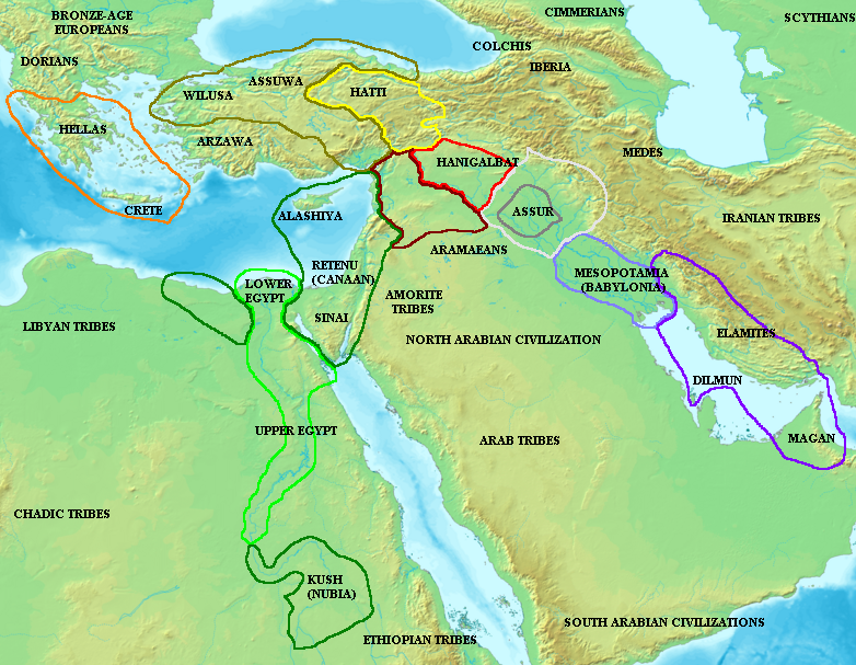
English: Map of the ancient Near East during the Amarna period, showing the great powers of the period: Egypt (green), Hatti (yellow), the Kassite kingdom of Babylon (purple), Assyria (grey), and Mittani (red). Lighter areas show direct control, darker areas represent spheres of influence. The extent of the Achaean/Mycenaean civilization is shown in orange.
On the map above: the territory between Medes and Iberia was called Ararat or Armenia, around the lake Van.
Русский: Карта Восточного Средиземноморья в Амарнский период (XIV век до н. э.). Территория Египта обведена зелёным, Митанни — красным, Хатти — жёлтым (покорённые ими территории обозначены более тёмными контурами того же цвета). |
||
| ቀን | |||
| ምንጭ |
|
||
| አቅራቢው | Briangotts |

የፈቃድ አይነት፦
I, the copyright holder of this work, hereby publish it under the following license:

|
Permission is granted to copy, distribute and/or modify this document under the terms of the GNU Free Documentation License, Version 1.2 or any later version published by the Free Software Foundation; with no Invariant Sections, no Front-Cover Texts, and no Back-Cover Texts. A copy of the license is included in the section entitled GNU Free Documentation License.http://www.gnu.org/copyleft/fdl.htmlGFDLGNU Free Documentation Licensetruetrue |
| This file is licensed under the Creative Commons Attribution-Share Alike 3.0 Unported license. | ||
| ||
| This licensing tag was added to this file as part of the GFDL licensing update.http://creativecommons.org/licenses/by-sa/3.0/CC BY-SA 3.0Creative Commons Attribution-Share Alike 3.0truetrue |
Captions
Add a one-line explanation of what this file represents
Map of the ancient Near East during the Amarna period (circa XIV—XII BC)
Карта Ближнего Востока и Восточного Средиземноморья в Амарнский период (около XIV—XII веков до н. э.)
Amarna garaiko Ekialde Hurbileko mapa (K.a. XIV.-XII. inguruan)
Items portrayed in this file
depicts እንግሊዝኛ
copyright status እንግሊዝኛ
copyrighted እንግሊዝኛ
media type እንግሊዝኛ
image/png
checksum እንግሊዝኛ
c093a27f18d734f778c94983fc27e97f3bfe0486
data size እንግሊዝኛ
761,236 byte
607 pixel
width እንግሊዝኛ
782 pixel
የፋይሉ ታሪክ
የቀድሞው ዕትም ካለ ቀን/ሰዓቱን በመጫን መመልከት ይቻላል።
| ቀን /ሰዓት | ናሙና | ክልሉ (በpixel) | አቅራቢው | ማጠቃለያ | |
|---|---|---|---|---|---|
| ያሁኑኑ | 09:55, 3 ዲሴምበር 2006 | | 782 × 607 (743 KB) | Electionworld | {{ew|en|Briangotts}} Map of the ancient Near East during the Amarna period, showing the great powers of the period: Egypt (green), Hatti (yellow), the Kassite kingdom of Babylon (purple), Assyria (grey), and Mittani (red). |
መያያዣዎች
የሚከተለው ገጽ ወደዚሁ ፋይል ተያይዟል፦
ሌሎች ውኪዎች
የሚከተሉት ሌሎች ውኪዎች ይህን ፋይል ይጠቀማሉ፦
- Usage on ar.wikipedia.org
- Usage on ast.wikipedia.org
- Usage on az.wikipedia.org
- Usage on ba.wikipedia.org
- Usage on be.wikipedia.org
- Usage on bs.wikipedia.org
- Usage on ca.wikipedia.org
- Usage on diq.wikipedia.org
- Usage on el.wikipedia.org
- Usage on en.wikipedia.org
- Usage on es.wikipedia.org
- Usage on eu.wikipedia.org
- Usage on fi.wikipedia.org
- Usage on fr.wikipedia.org
- Usage on fy.wikipedia.org
- Usage on he.wikipedia.org
- Usage on hu.wikipedia.org
- Usage on hy.wikipedia.org
- Usage on hyw.wikipedia.org
- Usage on id.wikipedia.org
- Usage on ja.wikipedia.org
- Usage on jv.wikipedia.org
- Usage on mk.wikipedia.org
- Usage on ml.wikipedia.org
View more global usage of this file.
ተጨማሪ መረጃ
ይህ ፋይል በውስጡ ተጨማሪ መረጃ ይይዛል። መረጃውም በዲጂታል ካሜራ ወይም በኮምፒውተር ስካነር የተጨመረ ይሆናል። ይህ ከኦሪጂናሉ ቅጅ የተለወጠ ከሆነ፣ ምናልባት የመረጃው ዝርዝር ለውጦቹን የማያንጸባረቅ ይሆናል።
| አድማሳዊ ማጉላት | 37.8 dpc |
|---|---|
| ቁም ማጉላት | 37.8 dpc |