Portal:Western Australia
Wikipedia portal for content related to Western Australia / From Wikipedia, the free encyclopedia
Portal maintenance status: (October 2020)
|
Introduction
 Western Australia (WA) is a state of Australia occupying the western third of the land area of the Australian continent.[text–source integrity?] It is bounded by the Indian Ocean to the north and west, the Southern Ocean to the south, the Northern Territory to the north-east, and South Australia to the south-east. With a total land area of 2,527,013 square kilometres (975,685 sq mi), Western Australia is Australia's largest state as well as the second-largest subdivision of any country on Earth, surpassed only by the Sakha Republic in eastern Russia. Western Australia has a diverse range of climates, including tropical conditions in the Kimberley, deserts in the interior (including the Great Sandy Desert, Little Sandy Desert, Gibson Desert, and Great Victoria Desert) and a Mediterranean climate on the south-west and southern coastal areas. the state has 2.91 million inhabitants—11 percent of the national total. Over 90 percent of the state's population live in the south-west corner and around 80 percent live in the state capital Perth, leaving the remainder of the state sparsely populated. The Trans-Australian Railway and the Eyre Highway traverse the Nullarbor Plain in the state's south-east, providing the principal connection between Western Australia and the population centres in the eastern states. (Full article...)
|


.JPG)


(Northern
Territory) |
 Good articles - load new batch
 Image 1
 Cyclone Sam making landfall on Australia at peak intensity on 8 December
Severe Tropical Cyclone Sam (JTWC designation: 03S) was an intense tropical cyclone that brought flooding rainfall to a wide swath of northern Australia in December 2000. The first tropical cyclone of the regional season, Sam originated from a tropical low that formed in the Arafura Sea on 28 November. Tracking generally westward, the initial low-pressure area remained generally weak until it entered the Timor Sea, by which time it had strengthened into a tropical cyclone on 5 December. Though a subtropical ridge was forcing the cyclone westward at the time, an approaching shortwave trough caused Sam to track southward the following day, towards the Australian coast. During its southward progression, Sam rapidly intensified, and reached its peak intensity on 8 December. Soon afterwards, the storm made landfall near Lagrange, Western Australia at the same intensity. Once inland, Sam was slow to weaken as it re-curved eastward, and persisted for nearly a week inland before dissipating on 14 December.
Throughout its existence, Cyclone Sam brought heavy rainfall to a wide swath of northern Australia. Rainfall peaked at 520 mm (20 in) in Shelamar over a 48-hour period ending on 11 December. Upon making landfall, damage was considerable, albeit localized. Most of the destruction wrought by Sam occurred near the coast, particularly in Bidyadanga and Anna Springs Station. Some buildings sustained considerable damage, and trees and power lines were felled, resulting in some power outages. Offshore, 163 illegal immigrants aboard two vessels were feared to have drowned, which would make Sam one of the deadliest cyclones in Australian history. However, these people were later accounted for. After the season, the name Sam was retired from the regional naming list. (Full article...)- Image 2
 Rosebery Street near Park Street
Bedford is a suburb 6 kilometres (4 mi) north-east of the central business district (CBD) of Perth, the capital of Western Australia. Named after Frederick Bedford, the Governor of Western Australia from 1903 to 1909, the suburb is within the City of Bayswater local government area. It is predominantly a low density residential suburb consisting of single-family detached homes, with clusters of commercial buildings along Beaufort Street, Grand Promenade and Walter Road.
Before European settlement, the area was inhabited by the Mooro group of the Whadjuk Noongar people. The first major developments for the suburb occurred in the 1920s, when the extension of Beaufort Street and its associated tram service into the area triggered housing construction. Bedford Park was gazetted as a townsite in 1937, and major growth occurred following World War II, due to developments by the State Housing Commission. Today, Bedford is fully suburbanised. (Full article...) - Image 3
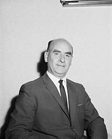 Tonkin in 1964
John Trezise Tonkin AC (2 February 1902 – 20 October 1995) was an Australian politician who was the premier of Western Australia from 3 March 1971 to 8 April 1974. A member of the Labor Party, Tonkin was a minister in the John Willcock, Frank Wise and Bert Hawke governments, and a member of the Western Australian Legislative Assembly from April 1933 to February 1977, making him the longest-serving member of the Parliament of Western Australia as of 2021.
Tonkin was born in the Goldfields town of Boulder, Western Australia, the eldest of three children. His family moved several times before returning to Boulder, where he attended Boulder City Central School and Eastern Goldfields High School. After working several jobs, he graduated from Claremont Teachers College and became a teacher, mainly working in small schools in rural areas. After several unsuccessful attempts to enter state parliament, Tonkin was elected as the member for North-East Fremantle in the 1933 state election. (Full article...) - Image 4
 A Transperth B-series train at Oats Street station in September 2021
Oats Street railway station is a temporarily-closed Transperth suburban railway station in Western Australia, located in the Perth suburbs of Carlisle and East Victoria Park. The station was served by the Armadale and Thornlie lines prior to its closure in November 2023.
Oats Street station opened on 28 November 1954, as the introduction of diesel railcars made it possible to build stations closer together. The station consisted of two side platforms north of the Oats Street level crossing. The CircleRoute bus began operating in 1998, allowing access to Curtin University from the Armadale line. A bus interchange was constructed soon thereafter, and Oats Street soon became one of the most important stations on the Armadale line. The Thornlie line opened in 2005, with Oats Street station being one of the few transfer stations between the two lines, further increasing its importance. Since 20 November 2023, the station has been closed to allow for the railway to be elevated and for Oats Street station to be rebuilt as an elevated station, as part of the Victoria Park-Canning Level Crossing Removal Project. The new station will straddle Oats Street and feature an expanded bus interchange. It is planned to reopen in mid-2025. (Full article...) - Image 5

Abyss is a steel roller coaster located at the Adventure World amusement park in Perth, Western Australia. The $12-million attraction was announced in April 2013, and construction began the following month. It opened to the general public six months later on 1 November 2013.
The Abyss is a Euro-Fighter, a roller coaster model from Gerstlauer that features a "beyond-vertical" first drop which exceeds 90 degrees. In addition to several inversions, the Abyss reaches a top speed of 85 kilometres per hour (53 mph) along the two-minute, 630-metre-long (2,070 ft) ride. (Full article...) - Image 6
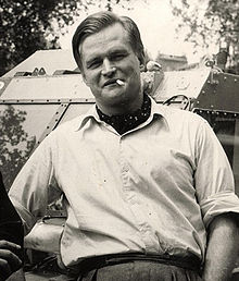 Carlin in Montreal in 1948
Frederick Benjamin Carlin (27 July 1912 – 7 March 1981) was an Australian adventurer who was the first person to circumnavigate the world in an amphibious vehicle. Born in Northam, Western Australia, Carlin attended Guildford Grammar School in Perth, and later studied mining engineering at the Kalgoorlie School of Mines. After qualifying as an engineer, he worked on the Goldfields before emigrating to China in 1939 to work in a British coal mine. In World War II, Carlin was posted to the Indian Army Corps of Engineers, serving in India, Italy, and throughout the Middle East. After his discharge from service in 1946, he emigrated to the United States with his American wife, Elinore (née Arone).
Sparked by an idea he had whilst in the military, Carlin proposed that the couple honeymoon by crossing the Atlantic Ocean in a modified Ford GPA (an amphibious version of the Ford GPW Jeep), which they named the Half-Safe. Beginning their trip in Montreal, Quebec, Canada, the Carlins finally completed the transatlantic crossing in 1951 after unsuccessful attempts. From there, they travelled to Europe, temporarily settling in Birmingham to raise more money. They resumed their journey in 1954, travelling overland through the Middle East before arriving in Calcutta. After a short fundraising trip to Australia, Carlin's wife left to return to the United States. He resumed the journey with new partners, travelling through South-East Asia and the Far East to the northern tip of Japan, and then to Alaska. After an extended tour through the United States and Canada, he and Half-Safe returned to Montreal, having travelled over 17,000 kilometres (11,000 mi) by sea and 62,000 kilometres (39,000 mi) by land during the ten-year journey. Following Carlin's death in 1981, Half-Safe was acquired by Guildford Grammar, his old school, where it remains on display. (Full article...) - Image 7
 Kerr at the 2019 FIFA Women's World Cup
Samantha May Kerr OAM (born 10 September 1993) is an Australian professional soccer player who plays as a striker for FA Women's Super League club Chelsea, and the Australia women's national team, which she has captained since 2019. Known for her speed, skill, and tenacity, Kerr is widely considered one of the best strikers in the world, and one of Australia's greatest athletes.
Kerr is the all-time leading Australian international scorer. and was the all-time leading scorer in the National Women's Soccer League (NWSL) in the United States until 2024. She is the only female soccer player to have won the Golden Boot in three different leagues and on three different continents—the W-League (Australia/New Zealand) in 2017–18 and 2018–19, the NWSL (North America) in 2017, 2018, and 2019, and the Women's Super League (Europe) in 2020–21 and 2021–22. (Full article...) - Image 8"Showdown" is the fourth single and first track from the album In Silico by Australian electronic rock band Pendulum. It has been remixed by several artists, including DJ Clipz (who is also Red Light) and Excision. It is also the first single taken from In Silico not to use the album logo prominently on its cover.
The single was originally released through various online music stores on 5 January 2009. It was not available in any physical format until 9 February, when Warner Music UK released the 12-inch picture disc of "Showdown". To help promote the single, Pendulum also released a Space Invaders themed video game which offered players a chance of winning an official framed gold disc of In Silico. (Full article...) - Image 9

The flag of Western Australia consists of a Blue Ensign defaced with the badge of the state. Adopted in 1953 to replace a similar design used from the time when the state was still a British colony, it has been the flag of Western Australia since 3 November of that year. The design of the present flag entailed reversing the direction of the black swan so that it faced towards the hoist. This was done in order to adhere to vexillological convention. Western Australia's flag is similar to the flags of the other five Australian states, which are also Blue Ensigns with their respective state badges. When flown with those state flags and the national flag, it is sixth in the order of precedence. This is indicative of its position on the Commonwealth Coat of Arms. (Full article...) - Image 10
 Cyclone Ilona at peak intensity on 17 December
Severe Tropical Cyclone Ilona caused moderate damage across the Pilbara region of Western Australia in mid-December 1988. The system originated from a monsoon trough that coalesced into a tropical low over the Timor Sea on 12 December. The system initially moved southwest, before moving on a more westerly course. Steady intensification occurred and Ilona reached its peak strength on 17 December as a low-end severe tropical cyclone. A southward turn directed the cyclone toward Western Australia, and it made landfall near Mardie Station. The system subsequently degraded over land and dissipated on 19 December.
The cyclone's effects were relatively limited, though locally significant damage was reported in areas such as Dampier and Karratha. Several homes lost their roof and downed power lines left towns without power for several days. No casualties were reported, damage amounted to A$1 million (US$725,000), and the name Ilona was retired after the season. (Full article...) - Image 11
 Viaduct beams in place at the Carlisle station site in February 2024
Carlisle railway station is a temporarily-closed suburban railway station on the Transperth network in Western Australia. It is in the Perth suburbs of Carlisle and East Victoria Park, and was predominantly served by Thornlie line services prior to its closure in November 2023.
The station first opened in July 1912. It was known as Mint Street station at first, but it was renamed Victoria Park East station in October 1912 and to its present name in May 1919. It gained a station master in 1922, which lasted until 1971. Carlisle station had minor upgrades from 2002 to 2003 in preparation for the opening of the Thornlie line, which happened in 2005. Since 20 November 2023, the station has been closed to undergo a complete rebuild as an elevated station as part of the Victoria Park-Canning Level Crossing Removal Project to remove a nearby level crossing. The station and line are planned to reopen in mid-2025. (Full article...) - Image 12
 View east of Cullacabardee
Cullacabardee is a northeastern rural suburb of Perth, the capital city of Western Australia, located 21 km (13 mi) from Perth's central business district via Alexander Drive or Beechboro Road. It is in the City of Swan local government area. Most of the suburb is covered in native sheoak and banksia forest. A small Noongar community is based on Baal Street, a drug rehabilitation retreat is located off Gnangara Road in the suburb's northeast, and the Perth International Telecommunications Centre facility is based in the suburb's northwest. (Full article...) - Image 13
 Aubin Grove bus station entrance in April 2017
Aubin Grove railway station is a suburban railway station serving Atwell, Aubin Grove, Hammond Park and Success, which are suburbs of Perth, Western Australia. It is on the Mandurah line, which is part of the Transperth network, and is located immediately north of Russell Road in the median of the Kwinana Freeway. It has two platform faces on a singular island platform, which is linked to either side of the freeway by a pedestrian overpass. Services run every 10 minutes during peak and every 15 minutes between peak. The journey to Perth station is 23.8 kilometres (14.8 mi) and takes 21 minutes. The station has a bus interchange with four bus stands and seven regular bus routes.
Construction of the station was promised by both major political parties ahead of the 2013 Western Australian state election. A tender was released for the station's construction in July 2014, with a projected cost of A$80 million for the whole project, including the purchase of two Transperth B-series trains. The design contract was awarded in February 2015 to a joint venture between Coniglio Ainsworth Architects and M. P. S. Architects. The scope of the project was broadened in April 2015 to include the widening of the Russell Road bridge over the freeway, which increased the project budget to $105 million. Construction on the station began in March 2016, and it was opened on 23 April 2017, with the final cost being $125 million. (Full article...) - Image 14William Dunn OAM (born 1911) was an Indigenous Australian pastoralist and elder from the Pilbara region of Western Australia (WA).
Dunn was the first Aboriginal person to be granted a cattle station lease in WA. His experience has been drawn upon by historians as an account of Aboriginal Australian experience in the 20th century, especially around the Pilbara. In his later years, he was an elder of the Jigalong community. (Full article...) - Image 15The Mitchell Freeway is a 41.5-kilometre-long (25.8 mi) freeway in the northern suburbs of Perth, Western Australia, linking central Perth with the city of Joondalup. It is the northern section of State Route 2, which continues south as Kwinana Freeway and Forrest Highway. Along its length are interchanges with several major roads, including the Graham Farmer Freeway and Reid Highway. The southern terminus of the Mitchell Freeway is at the Narrows Bridge, which crosses the Swan River, and the northern terminus is at Romeo Road in Alkimos.
Planning for the route began in the 1950s, and the first segment in central Perth was constructed between 1967 and 1973. Named after Sir James Mitchell, the freeway has been progressively extended north since then. In the 1970s, the first two extensions were completed, up to Hutton Street in Osborne Park. By the end of the 1980s, the freeway had reached Ocean Reef Road in Edgewater. The Joondalup railway line was constructed in the freeway median in the early 1990s. This necessitated the relocation of a section of the southbound carriageway, and the construction of three new bridges. In conjunction with these works, additional lanes were constructed in the realigned section. (Full article...)


_1.jpg)

.jpg)


Did you know (auto-generated)

- ... that the search for a lost radioactive capsule along a 1,400-kilometre (870 mi) stretch of road in Western Australia was likened to looking for a needle in a haystack?
- ... that politician John D'Orazio helped to secure a three-year trial of daylight saving time in Western Australia?
- ... that Bill Dunn, an Indigenous Australian pastoralist approaching retirement, sold his station at half-price to the Jigalong community despite receiving full-price offers from non-Indigenous people?
- ... that Nick Goiran, a member of the Western Australian Legislative Council, proposed 357 amendments to a voluntary assisted dying bill?
- ... that Western Australia was the second Australian state to legalise voluntary assisted dying?
Categories

More portals
More did you know...

- ...that when the 1987 America's Cup was raced off Fremantle, Western Australia it was the first time for 132 years that the regatta had not been hosted by the New York Yacht Club?
- ...that the original Victoria Dam, constructed in 1891, was the first dam in Western Australia, and it stood for almost 100 years before being replaced with the current dam?
- ...that Anglican bishop Kay Goldsworthy was consecrated as the first woman bishop of any Australian church on 22 May 2008?
Related WikiProjects

Things you can do
Here are some tasks you can do to help with WikiProject Western Australia:
Associated Wikimedia
The following Wikimedia Foundation sister projects provide more on this subject:
-
 Commons
Free media repository -
 Wikibooks
Free textbooks and manuals -
 Wikidata
Free knowledge base -
 Wikinews
Free-content news -
 Wikiquote
Collection of quotations -
 Wikisource
Free-content library -
 Wikispecies
Directory of species -
 Wikiversity
Free learning tools -
 Wikivoyage
Free travel guide -
 Wiktionary
Dictionary and thesaurus


