File:Gps-atmosphericefects.xcf
From Wikipedia, the free encyclopedia

Size of this PNG preview of this XCF file: Amachashazikazi ama-608 adlulayo nama-599 amile. Other resolutions: Amachashazikazi ama-243 adlulayo nama-240 amile | Amachashazikazi ama-487 adlulayo nama-480 amile | Amachashazikazi ama-849 adlulayo nama-837 amile.
Ifayela ewu ngqo (849 × 837 pixels, file size: 539 KB, MIME type: image/x-xcf)
This file is from Wikimedia Commons and may be used by other projects. The description on its file description page there is shown below.
|
|
| IncazeloGps-atmosphericefects.xcf |
Español: Efecto de la atmósfera en la propagación de la señal GPS.
English: Effect of the atmosphere in the GPS signal propagation. |
| Usuku | (UTC) |
| Umthombo | |
| Umlobi |
|
| Other versions |
| This is a retouched picture, which means that it has been digitally altered from its original version. Modifications: Collage. The original can be viewed here: GPS tracking satellites.jpg:
|
This file is licensed under the Creative Commons Attribution-Share Alike 3.0 Unported license.
- Ukhululekile:
- ukwabelana – to copy, distribute and transmit the work
- to remix – to adapt the work
- Ngaphansi kwezimo ezilandelayo:
- attribution – You must give appropriate credit, provide a link to the license, and indicate if changes were made. You may do so in any reasonable manner, but not in any way that suggests the licensor endorses you or your use.
- yabelana ngokufana – If you remix, transform, or build upon the material, you must distribute your contributions under the same or compatible license as the original.
Original upload log
This image is a derivative work of the following images:
- File:The_Earth_seen_from_Apollo_17.jpg licensed with PD-USGov-NASA
- 2004-11-08T15:18:10Z Ævar Arnfjörð Bjarmason 1860x1898 (5274108 Bytes)
- File:Navstar-2.jpg licensed with PD-USGov-Military-Air Force
- 2005-03-26T18:06:36Z GDK 400x400 (20897 Bytes) NAVSTAR-2 (GPS-2) satellite Source: http://www.jpl.nasa.gov/images/grace/grace_083002_browse.jpg Status: PD-USGov-Military-Air Force {{PD-USGov-Military-Air Force}} [[Category:Satellites]]
- File:GPS_tracking_satellites.jpg licensed with Cc-by-sa-2.5,2.0,1.0, Cc-by-sa-3.0-migrated, GFDL
- 2007-04-21T06:19:59Z Theonlysilentbob 1536x2048 (385521 Bytes) == Summary == {{Information |Description = Garmin eTrex Yellow GPS acquiring satellite signal |Source = Not Applicable |Date = April 21st 2007 |Author = Vaughan Weather |Permission = Anyone can use and freely distribute this
Uploaded with derivativeFX
Captions
Add a one-line explanation of what this file represents
Items portrayed in this file
depicts i-English
copyright status i-English
copyrighted i-English
copyright license i-English
inception i-English
9 uMbasa 2010
Umlando womqulu
Click on a date/time to view the file as it appeared at that time.
| Usuku/Isikhathi | Isithonjana | Dimensions | Umsebenzisi | Amazwana | |
|---|---|---|---|---|---|
| Njengamanje | 14:10, 9 uMbasa 2010 | 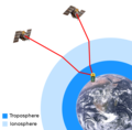 | 849 × 837 (539 KB) | Javiersanp | {{Information |Description={{en|1=aaa}} |Source={{own}} |Author=Javiersanp |Date= |Permission= |other_versions= }} |
Ukusetshenziswa komqulu
Awekho amakhasi asebenzisa lolu hlobo lomqulu.