热门问题
时间线
聊天
视角
克拉尼斯卡
来自维基百科,自由的百科全书
Remove ads
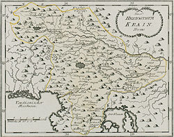
卡尼奥拉(英語、意大利语:Carniola)或克拉尼斯卡(斯洛文尼亚语:Kranjska)、克雷恩(德语:Krain)是斯洛文尼亚境内的一个历史地名。在中文里经常依据英语的名称而翻译为“卡尼奥拉”。
在奥匈帝国时期,克拉尼斯卡地区是一个公国,即卡尼奥拉公国(Herzogtum Krain)。整个地区被分为三部分:上卡尼奥拉,下卡尼奥拉(与白卡尼奥拉一起)和内卡尼奥拉。公国的首府开始是在克拉尼(克雷恩堡),后来移到了卢布尔雅那(现在斯洛文尼亚共和国的首都)。
1918年奥匈帝国在第一次世界大战中战败,帝国解体,卡尼奥拉公国也随之停止废除。克拉尼斯卡地区被并入新成立的南斯拉夫王国。在1992年南斯拉夫社会主义联邦共和国解体、斯洛文尼亚独立后,原克拉尼斯卡地区成为新成立的斯洛文尼亚国家的核心部分。
卡尼奥拉公国西部的一些城镇在1920年被并入意大利。
Remove ads
资料来源
- 本条目包含来自公有领域出版物的文本: Chisholm, Hugh (编). Encyclopædia Britannica (第11版). London: Cambridge University Press. 1911.
延伸阅读
- Dimitz, August, History of Carniola: From Primeval Times to the death of Emperor Frederick III (1493) I, Witter, Andrew J., translator, Slovenian Genealogical Society International, 2013 [1875], ISBN 978-1-48360-408-4
- Dimitz, August, History of Carniola: From the Accession of Maximilian I (1493) to the Year 1813 II, Witter, Andrew J., translator, Slovenian Genealogical Society International, 2013 [1875], ISBN 978-1-48360-410-7
- Dimitz, August, History of Carniola: From the Accession of Archduke Karl to Leopold I (1564–1657) III, Witter, Andrew J., translator, Slovenian Genealogical Society International, 2013 [1875], ISBN 978-1-48360-412-1
- Dimitz, August, History of Carniola: To the end of French Rule in Illyria (1813) IV, Witter, Andrew J., translator, Slovenian Genealogical Society International, 2013 [1875], ISBN 978-1-48360-417-6
Remove ads
Wikiwand - on
Seamless Wikipedia browsing. On steroids.
Remove ads


