File:Pula_Aerial_View.jpg
維基百科,自由的 encyclopedia
本预览的尺寸:800 × 488像素。 其他分辨率:320 × 195像素 | 640 × 390像素 | 1,024 × 625像素 | 1,495 × 912像素。
原始文件 (1,495 × 912像素,文件大小:1.01 MB,MIME类型:image/jpeg)

|
根据最有价值图像标准,这张图像被评定为在Pula, Croatia范畴内最有价值的共享资源图像。你可以在Commons:Valued image candidates/Pula Croatia2参看它的提名。 |
| 描述Pula Aerial View.jpg |
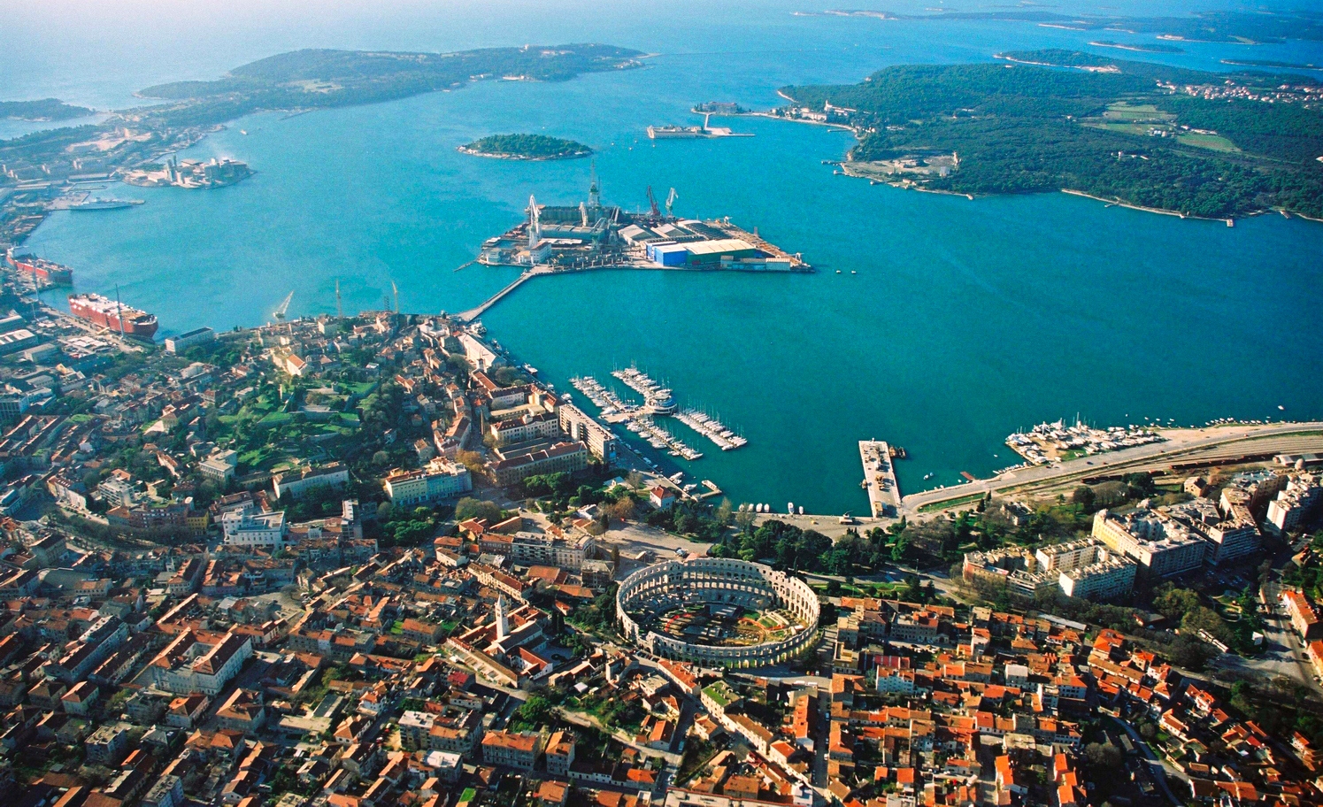
English: Aerial view of Pula, Croatia. The most notable object, on the bottom of the photo, is the Arena Amphiteathre. Left of it is the hill around which lies the Old Town. The wedge-shaped island in the middle of the bay is Uljanik, part of the shipyard. On the far top right the Brijuni islands (a National Park) can be seen.
Русский: Вид с высоты птичьего полета на Пулу (Хорватия). Самый примечательный объект, расположенный в нижней части фотографии, это амфитеатр Пулы. Слева от него находится холм, вокруг которого раскинулся Старый город. Клиновидный остров посреди бухты - это Uljanik, часть верфи. В дальнем правом верхнем углу видны острова Бриони (национальный парк). |
||||||||
| 日期 | 02:57, 19 ago 2007 (dati Exif) | ||||||||
| 来源 |
self-made, better version than |
||||||||
| 作者 | Orlovic | ||||||||
| 授权 (二次使用本文件) |
|
| 相机位置 | 44° 52′ 21.6″ 北, 13° 51′ 26.9″ 东 | 在以下服务上查看本图像和附近其他图像: OpenStreetMap |
|---|
Notes
- I uploaded it also on Panoramio, but only after doing it on commons --Orlovic 21:40, 5 February 2007 (UTC)

|
已授权您依据自由软件基金会发行的无固定段落及封面封底文字(Invariant Sections, Front-Cover Texts, and Back-Cover Texts)的GNU自由文件许可协议1.2版或任意后续版本的条款,复制、传播和/或修改本文件。该协议的副本请见“GNU Free Documentation License”。http://www.gnu.org/copyleft/fdl.htmlGFDLGNU Free Documentation Licensetruetrue |
| 本文件采用知识共享署名-相同方式共享 3.0 未本地化版本许可协议授权。 | ||
| ||
| 本许可协议标签作为GFDL许可协议更新的组成部分被添加至本文件。http://creativecommons.org/licenses/by-sa/3.0/CC BY-SA 3.0Creative Commons Attribution-Share Alike 3.0truetrue |
| 註解 InfoField | 該圖片含有註解:在維基媒體共享資源上查看註解 |
690
622
245
142
1495
912
The Roman Arena.
520
402
80
65
1495
912
The Pula Cathedral.
316
391
54
39
1495
912
The Monastery and Church of St. Francis.
363
361
49
32
1495
912
The Forum (Central Square).
303
432
118
52
1495
912
The Venetian fortress (The Citadel).
28
546
37
30
1495
912
The Arch of the Sergii (Ancient Roman triumphal arch).
523
673
116
86
1495
912
St Anthony's Church (Crkva svetog Antuna).
说明
添加一行文字以描述该文件所表现的内容
共享资源质量评价 简体中文(已转写)
44°52'21.601"N, 13°51'26.899"E
image/jpeg
文件历史
点击某个日期/时间查看对应时刻的文件。
| 日期/时间 | 缩略图 | 大小 | 用户 | 备注 | |
|---|---|---|---|---|---|
| 当前 | 2007年8月19日 (日) 01:06 | | 1,495 × 912(1.01 MB) | Orlovic | {{Information |Description=Aerial view of Pula, Croatia |Source= My friend gave me the photo to publish under GFDL, better version than 50px |Date= |Author= Darko D. |permission={{GFDL}} }} == Notes == *I uploaded it also on [htt |
| 2007年8月19日 (日) 01:01 |  | 1,495 × 1,000(1.68 MB) | Orlovic | {{Information |Description=Aerial view of Pula, Croatia |Source= My friend gave me the photo to publish under GFDL, better version than 50px |Date= |Author= Darko D. |permission={{GFDL}} }} == Notes == *I uploaded it also on [htt |
文件用途
以下3个页面使用本文件:
全域文件用途
以下其他wiki使用此文件:
- af.wikipedia.org上的用途
- ar.wikipedia.org上的用途
- arz.wikipedia.org上的用途
- avk.wikipedia.org上的用途
- az.wikipedia.org上的用途
- ba.wikipedia.org上的用途
- be-tarask.wikipedia.org上的用途
- be.wikipedia.org上的用途
- bg.wikipedia.org上的用途
- bs.wikipedia.org上的用途
- ca.wikipedia.org上的用途
- ceb.wikipedia.org上的用途
- cs.wikipedia.org上的用途
- cy.wikipedia.org上的用途
- da.wikipedia.org上的用途
- de.wikipedia.org上的用途
- de.wikivoyage.org上的用途
- el.wikipedia.org上的用途
- en.wikipedia.org上的用途
- en.wikivoyage.org上的用途
查看此文件的更多全域用途。
元数据
此文件中包含有扩展的信息。这些信息可能是由数码相机或扫描仪在创建或数字化过程中所添加。
如果此文件的源文件已经被修改,一些信息在修改后的文件中将不能完全反映出来。
| 方向 | 正常 |
|---|---|
| 水平分辨率 | 72 dpi |
| 垂直分辨率 | 72 dpi |
| 使用软件 | Adobe Photoshop CS2 Windows |
| 文件修改日期时间 | 2007年8月19日 (日) 02:57 |
| 色彩空间 | 未标定 |
| 图像宽度 | 1,495 px |
| 图像高度 | 1,000 px |
| 数字化日期时间 | 2007年8月19日 (日) 04:57 |
| 元数据最后修改日期 | 2007年8月19日 (日) 04:57 |