File:Assam_in_India.png
維基百科,自由的 encyclopedia
此为最大尺寸。
Assam_in_India.png (350 × 426像素,文件大小:76 KB,MIME类型:image/png)
摘要
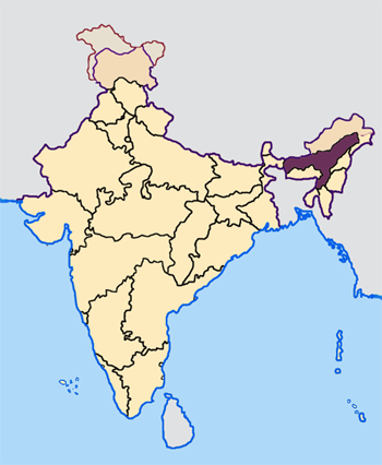
| 描述Assam in India.png | Note: The Indian state of w:Jammu and Kashmir is claimed by w:India, w:Pakistan and the w:People's Republic of China. This map depicts the boundaries of the state as it was in 1947. Areas administered by India is coloured as per the rest of the states, and the area administered by Pakistan and China are coloured in a neutral colour. See the map of Jammu and Kashmir. The Indian state of w:Arunachal Pradesh is claimed by China as a part of w:South Tibet. The claimed region is depicted in a pale shade of pink. See the map of Arunachal Pradesh. The Indian territorial waters extend to a distance of twelve nautical miles. |
| 日期 | 1947年. |
| 来源 | 原始上传者自己的作品 |
| 作者 | Map made by me, Nichalp |
许可协议

|
已授权您依据自由软件基金会发行的无固定段落及封面封底文字(Invariant Sections, Front-Cover Texts, and Back-Cover Texts)的GNU自由文件许可协议1.2版或任意后续版本的条款,复制、传播和/或修改本文件。该协议的副本请见“GNU Free Documentation License”。http://www.gnu.org/copyleft/fdl.htmlGFDLGNU Free Documentation Licensetruetrue |
| 本文件采用知识共享署名-相同方式共享 3.0 未本地化版本许可协议授权。 | ||
| ||
| 本许可协议标签作为GFDL许可协议更新的组成部分被添加至本文件。http://creativecommons.org/licenses/by-sa/3.0/CC BY-SA 3.0Creative Commons Attribution-Share Alike 3.0truetrue |
说明
添加一行文字以描述该文件所表现的内容
此文件中描述的项目
描繪內容
image/png
77,982 字节
426 像素
350 像素
文件历史
点击某个日期/时间查看对应时刻的文件。
| 日期/时间 | 缩略图 | 大小 | 用户 | 备注 | |
|---|---|---|---|---|---|
| 当前 | 2005年4月23日 (六) 07:27 | | 350 × 426(76 KB) | Nichalp | NPOV map |
| 2005年4月23日 (六) 07:21 |  | 200 × 231(22 KB) | Kerpal | Reverted to earlier revision | |
| 2005年4月23日 (六) 06:16 |  | 500 × 608(121 KB) | Nichalp | Reverted to earlier revision | |
| 2005年4月23日 (六) 04:59 |  | 200 × 231(22 KB) | Kerpal | Reverted to earlier revision | |
| 2005年4月23日 (六) 04:50 |  | 500 × 608(121 KB) | Nichalp | Reverted to earlier revision | |
| 2005年4月22日 (五) 21:04 |  | 200 × 231(22 KB) | Kerpal | Reverted to earlier revision | |
| 2005年4月22日 (五) 13:39 |  | 500 × 608(121 KB) | Nichalp | Reverted to earlier revision | |
| 2005年4月22日 (五) 13:35 |  | 500 × 608(121 KB) | Nichalp | Reverted to earlier revision | |
| 2005年4月22日 (五) 09:55 |  | 200 × 231(22 KB) | Kerpal | originally by en:User:Morwen | |
| 2005年4月21日 (四) 17:49 |  | 500 × 608(121 KB) | Nichalp | Map made by me, ~~~ Note: The Indian state of w:Jammu and Kashmir is claimed by w:India, w:Pakistan and the w:People's Republic of China. This map depicts the boundaries of the state as it was in 1947. Areas administered by India is colo |
文件用途
以下8个页面使用本文件:
全域文件用途
以下其他wiki使用此文件:
- as.wikipedia.org上的用途
- bn.wikipedia.org上的用途
- bs.wikipedia.org上的用途
- bxr.wikipedia.org上的用途
- en.wikipedia.org上的用途
- Kamarupa
- History of Assam
- Danava dynasty
- Kamata Kingdom
- Timeline of history of Assam
- Dimasa Kingdom
- Assam Movement
- Bhauma dynasty
- Ahom kingdom
- Colonial Assam
- Template:History of Assam
- 2008 Assam bombings
- Chutia Kingdom
- 2009 Guwahati bombings
- 2009 Assam bombings
- 2004 Indian general election in Assam
- 2009 Indian general election in Assam
- Assam separatist movements
- Dark Age of the Assamese language
- 2012 Assam violence
- Koch–Ahom relations
- 2014 Indian general election in Assam
- Asura Kingdom
- Operation Bajrang
- en.wikinews.org上的用途
- hi.wikipedia.org上的用途
- ka.wikipedia.org上的用途
- pl.wikipedia.org上的用途
查看此文件的更多全域用途。
元数据
此文件中包含有扩展的信息。这些信息可能是由数码相机或扫描仪在创建或数字化过程中所添加。
如果此文件的源文件已经被修改,一些信息在修改后的文件中将不能完全反映出来。
| 使用软件 |
|---|