| 迪塞普遜島 | |
|---|---|
| 海拔 | 602公尺[convert: 不明單位] |
| 地理 | |
| 國家 | 無 |
| 地質 | |
| 山脈類型 | 破火山口 |
此條目可參照英語維基百科相應條目來擴充。 (2018年12月17日) |


阿根廷科學考察站 Decepción (2016)

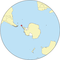
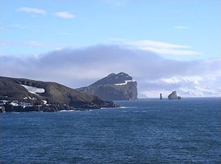
迪塞普遜島[2](英語:Deception Island),又稱欺騙島[3],是南極洲的火山島,位於南極大陸對開海域,屬於南設得蘭群島的一部分,長14.4公里、寬12.2公里,面積136.9平方公里,最高點海拔高度576米[4],最近一次火山噴發在1970年發生[5]。
1820年11月15日,美國海豹獵人納撒尼爾·帕爾默首次探索,該島外形和普通島嶼並無二致,但實際上是一個被淹沒的破火山口,他因為此視錯覺將該島命名為「欺騙島」(Deception)。[6]島東南部有一個叫涅普頓風箱的狹窄入口,以羅馬神涅普頓命名,風箱指進出時的強烈陣風。島內的福斯特港[7][8]是良好的避風港[9]。
此島上並無人居住,該島的領土主權問題,按南極條約體系處理。
外部連結
- Volcanic Activity (頁面存檔備份,存於網際網路檔案館). Accessed 4 June 2007.
- Deception Island, Eco-Photo Explorers. Accessed 3 May 2007.
- Images from Deception Island (頁面存檔備份,存於網際網路檔案館)
- "Steamed Ice and Frosted Lava" (頁面存檔備份,存於網際網路檔案館) Account of a tourist visit to Deception Island
- British Deception Island station
另見
- 63rd parallel south 南緯63度線
- Baily Head 貝利角
- Bynon Hill 拜農山
- Crater Lake (South Shetland Islands) 火山口湖 (南極洲)
- Crimson Hill 克里姆森山
- Entrance Point 入口角
- Fildes Point 菲爾德斯角
- Fumarole Bay 五月一日灣
- List of Volcanoes in Antarctica 南極洲火山列表
- Macaroni Point 馬卡羅尼角
- Mount Achala 阿查拉山
- Mount Pond 龐德山
- Mount Kirkwood 柯克伍德山
- Mount Uritorco 烏里托爾科山
- New Rock (South Shetland Islands) 新岩
- Pendulum Cove 鐘擺灣
- Penfold Point 奔富角
- Port Foster 福斯特港
- Rancho Point 蘭楚角
- Ravn Rock 拉文岩
- Relict Lake 殘餘湖
- Research stations in Antarctica 南極科學考察站
- Sail Rock (South Shetland Islands) 風帆岩
- Smolensk Strait 斯莫倫斯克海峽
- South East Point (South Shetland Islands) 東南角
- South Point (Deception Island) 南角
- Stancomb Cove 斯坦科姆灣
- Stonethrow Ridge 掉石嶺
- Telefon Bay 特萊豐灣
- Telefon Ridge 特萊豐嶺
- Vapour Col 蒸氣山坳
- Whalers Bay (South Shetland Islands) 捕鯨者灣
參考資料
Wikiwand in your browser!
Seamless Wikipedia browsing. On steroids.
Every time you click a link to Wikipedia, Wiktionary or Wikiquote in your browser's search results, it will show the modern Wikiwand interface.
Wikiwand extension is a five stars, simple, with minimum permission required to keep your browsing private, safe and transparent.

