班韦乌卢湖
赞比亚湖泊 来自维基百科,自由的百科全书
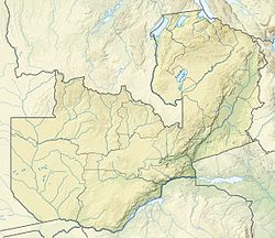
班韦乌卢湖(Lake Bangweulu)跟班韦乌卢沼地和班韦乌卢平原组成其中一个全球最大的湿地系统,位于赞比亚卢阿普拉省的刚果河上游流域,总面积与美国康涅狄格州相若,海拔1,140米,是重要的生态系统。班韦乌卢湖的面积约3,000平方公里,在5月雨季结束时因沼地和平原被淹没而面积增加至15,000平方公里,平均深度只有4米左右。[2][3]
参考文献
Wikiwand in your browser!
Seamless Wikipedia browsing. On steroids.
Every time you click a link to Wikipedia, Wiktionary or Wikiquote in your browser's search results, it will show the modern Wikiwand interface.
Wikiwand extension is a five stars, simple, with minimum permission required to keep your browsing private, safe and transparent.


