File:NS_administrative_Gliederung_1944.png
維基百科,自由的 encyclopedia
原始檔案 (8,000 × 6,094 像素,檔案大小:4.14 MB,MIME 類型:image/png)

|
本圖片是以PNG、GIF或JPEG格式上傳。然而,其中包含的資料或訊息,應該重新建立成可縮放向量圖形(SVG)檔案,以更有效率或更準確的方式儲存。如有可能,請上傳本圖片的SVG格式版本。在上傳之後,請修改維基各姊妹計畫中所有使用舊版圖片的條目(列在圖像連結章節中),替換為新版圖片,並在舊圖片的描述頁中加入{{Vector version available|新圖片名稱.svg}}模板,同時移除本模板。
|
摘要
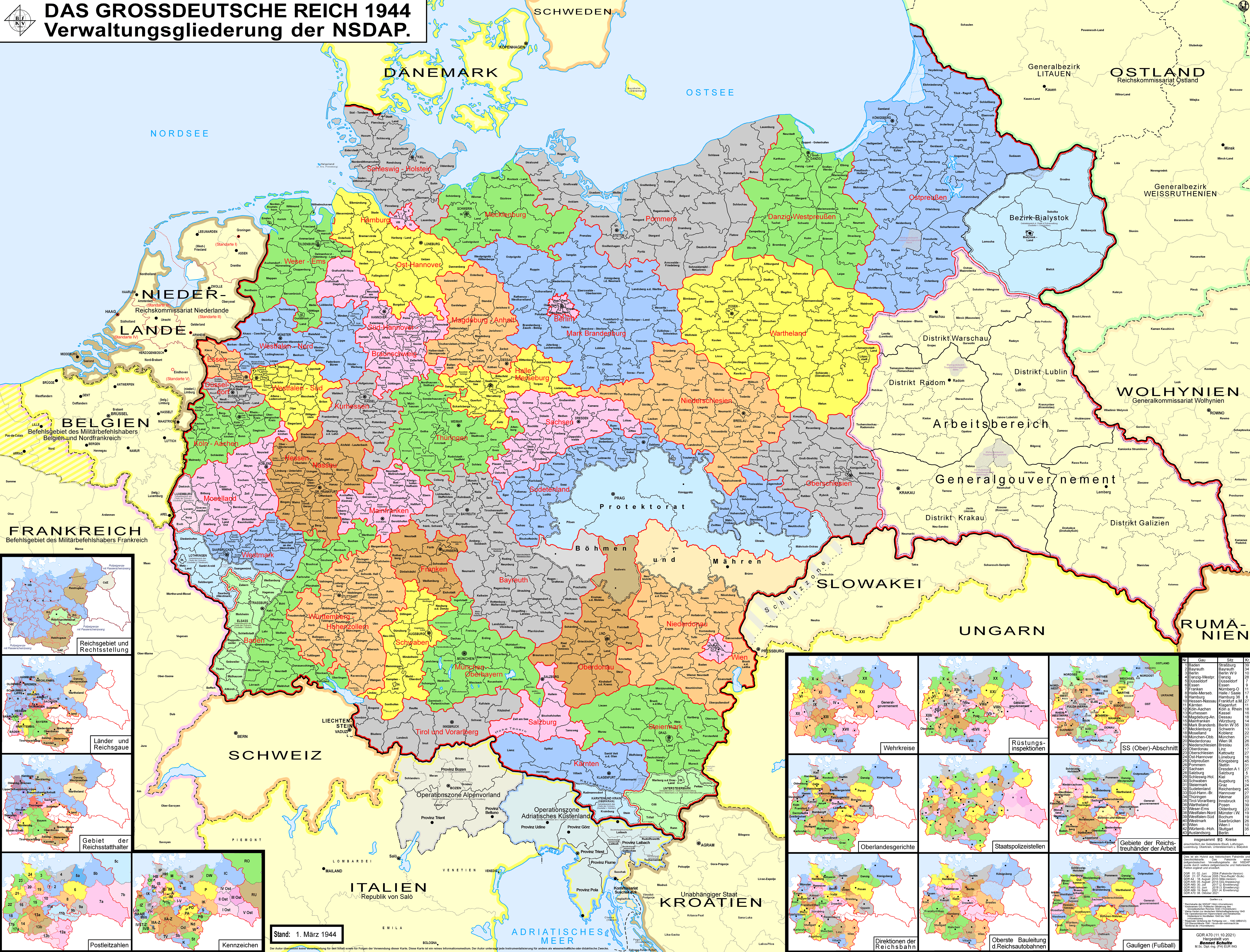
| 描述NS administrative Gliederung 1944.png |
Беларуская (тарашкевіца): Мапа адміністрацыйна-тэрытарыяльнага падзелу Вялікага нямецкага райху паводле НСДАП (1944).
Deutsch: Karte der Verwaltungsgliederung des Großdeutschen Reiches durch die NSDAP 1944. Sie zeigt die Kreise, Gaue und Reichsgaue der NSDAP. Zudem die Länder, die Gebiete der Reichsstatthalter und die Rechtsstellung der Reichsteile. Zusätzlich Postleitzahlen, Kennzeichen, Wehrkreise, Oberlandesgerichte, Staatspolizeistellen, Direktionen der Reichsbahn, Oberste Bauleitung der Reichsautobahnen und Arbeitsamtsgebiete 1944.
English: Map of the administrative division of the Greater German Reich (»Großdeutsches Reich«/»Großdeutschland«/"Greater German Empire"/"Greater Germany") by the NSDAP (Nazi Party) 1944, showing Kreise, Gaue and Reichsgaue. In addition, the states, the territories of the Reichsstatthalter and the legal status of Reich territories. Additionally postal codes, license plates, military districts, higher regional courts, State Police offices, railway directorates, Supreme construction management of the highways and work coordination areas 1944.
Polski: Mapa Wielkiej Rzeszy Niemieckiej (1944)
Русский: Административно-территориальное деление Третьего Рейха - Великой Германии (1944)
Українська: Адміністративно-територіальний поділ Третього Рейху - Великої Німеччини (1944) |
||
| 日期 | |||
| 來源 | 自己的作品 | ||
| 作者 | Bennet Schulte | ||
| 授權許可 (重用此檔案) |
此檔案採用創用CC 姓名標示-相同方式分享 3.0 德國授權條款。
 |
||
| 其他版本 |
|


| 註解 InfoField | 該圖片含有註解:在維基媒體共享資源上查看註解 |
Distrikt Galizien
Partei-Gau/Reichsgau Wartheland
Distrikt Warschau
Partei-Gau Ostpreußen
Distrikt Lublin
Distrikt Radom
Distirkt Krakau
Partei-Gau Oberschlesien
Partei-Gau Niederschlesien
Partei-Gau/Reichsgau Sudetenland
說明
在此檔案描寫的項目
描繪內容
創用CC姓名標示-相同方式分享3.0德國 繁體中文 (已轉換拼寫)
18 8 2010
多媒體型式 繁體中文 (已轉換拼寫)
image/png
檔案歷史
點選日期/時間以檢視該時間的檔案版本。
| 日期/時間 | 縮圖 | 尺寸 | 用戶 | 備註 | |
|---|---|---|---|---|---|
| 目前 | 2021年10月12日 (二) 03:32 | | 8,000 × 6,094(4.14 MB) | Exec | resolution reduzed |
| 2021年10月12日 (二) 03:31 |  | 17,392 × 13,248(4.99 MB) | Exec | -render modus of previous version fixed | |
| 2021年10月11日 (一) 13:09 |  | 8,000 × 6,094(7.98 MB) | Exec | - Lublin-Galicia-Adjustment implemented, Galicia internal boundaries redone, modifications at Desitrikt Bialystok | |
| 2021年10月6日 (三) 10:36 |  | 8,000 × 6,094(22.08 MB) | Kamilhrub | Corrected name Hrubieszow and southern borders of Bilgoraj, Hrubieszow and Zamosc districts, which didn't change after 1941 (source: Amtliches Gemeinde- und Dorfverzeichnis für das Generalgouvernement auf Grund der Summarischen Bevölkerungsbestandsaufnahme am 1. März 1943) | |
| 2021年9月19日 (日) 22:27 |  | 8,000 × 6,094(19.36 MB) | Exec | content exansion on multiple aspects | |
| 2021年9月19日 (日) 22:15 |  | 8,000 × 6,094(8.37 MB) | Exec | inhaltliche Erweiterung verschiedenster Art | |
| 2021年2月21日 (日) 00:33 |  | 8,000 × 6,094(22.22 MB) | Exec | - additional small map of Wehrinspektionen; minor corrections | |
| 2019年4月12日 (五) 14:57 |  | 8,000 × 6,094(3.46 MB) | FDRMRZUSA | Lower resolution but better display: no more display problems and same image quality. Previous file too big: bigger dimensions not necessary. Reduced size: compressed and optimized. No other changes. | |
| 2018年6月5日 (二) 21:54 |  | 17,392 × 13,248(11.47 MB) | Exec | - another color correction | |
| 2018年6月5日 (二) 21:33 |  | 17,366 × 13,226(11.46 MB) | Exec | Color Error Correction |
檔案用途
下列44個頁面有用到此檔案:
- 上多瑙帝国大区
- 上西里西亚大区
- 下西里西亚大区
- 东汉诺威大区
- 但泽-西普鲁士帝国大区
- 勃兰登堡边境大区
- 南漢諾威-不倫瑞克大區
- 哈雷-梅泽堡大区
- 圖林根大區
- 埃森大区
- 大区 (德国)
- 威悉-埃姆斯大区
- 威斯特法伦-北方大区
- 威斯特法伦-南方大区
- 威斯特马克大区
- 巴登大区
- 帝國大區
- 弗兰肯大区
- 德国前东部领土
- 慕尼黑-上巴伐利亚大区
- 拜罗伊特大区
- 摩泽尔兰大区
- 施瓦本大区
- 杜塞尔多夫大区
- 柏林大区
- 梅克伦堡大区
- 汉堡大区
- 波美拉尼亚大区
- 瓦尔特兰帝国大区
- 石勒苏益格-荷尔斯泰因大区
- 科隆-亚琛大区
- 符腾堡-霍亨索伦大区
- 納粹德國
- 維恩帝國大區
- 纳粹德国行政区划
- 美因弗兰肯大区
- 萨尔茨堡帝国大区
- 蘇台德蘭帝國大區
- 西里西亚大区
- 马格德堡-安哈尔特大区
- 黑森-拿骚大区
- 黑森选侯大区
- User:BlackShadowG/沙盒/Portal
- Portal:納粹德國
全域檔案使用狀況
以下其他 wiki 使用了這個檔案:
- af.wikipedia.org 的使用狀況
- an.wikipedia.org 的使用狀況
- ar.wikipedia.org 的使用狀況
- ast.wikipedia.org 的使用狀況
- azb.wikipedia.org 的使用狀況
- ba.wikipedia.org 的使用狀況
- be-tarask.wikipedia.org 的使用狀況
- be.wikipedia.org 的使用狀況
- bg.wikipedia.org 的使用狀況
- bn.wikipedia.org 的使用狀況
- br.wikipedia.org 的使用狀況
- bs.wikipedia.org 的使用狀況
- ca.wikipedia.org 的使用狀況
- Protectorat de Bohèmia i Moràvia
- Potències de l'Eix
- Partit Nacionalsocialista Alemany dels Treballadors
- Zona d'Operacions dels Prealps
- Gauleiter
- Gran Alemanya
- Govern General
- Divisions administratives de l'Alemanya nazi
- Zona d'Operacions del Litoral Adriàtic
- Viquipèdia:Estat Lliure de Prússia
- Usuari:Casablanca~cawiki/Estat Lliure de Prússia
- Reichsgau
- Gau de Magdeburg-Anhalt
- Gau de Halle-Merseburg
- Gau de Baden
- Gau de Württemberg-Hohenzollern
- Gau de Bayreuth
- Gau de Francònia
- Gau de Main-Francònia
- Gau de Múnic-Alta Baviera
- Gau de Suàbia
- Gau de Hannover del Sud-Brunsvic
- Gau de Hannover Oriental
- Gau de Turíngia
檢視此檔案的更多全域使用狀況。
詮釋資料
此檔案中包含擴展的資訊。這些資訊可能是由數位相機或掃描器在建立時或數位化過程中所加入。
如果此檔案的來源檔案已被修改,一些資訊在修改後的檔案中將不能完全反映出來。
| 使用軟體 |
|---|