File:Map_administrative_divisions_of_the_First_French_Empire_1812-en.svg
維基百科,自由的 encyclopedia

原始檔案 (SVG 檔案,表面大小:2,052 × 1,728 像素,檔案大小:4.14 MB)
摘要
| 描述Map administrative divisions of the First French Empire 1812-en.svg |
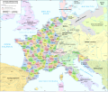
Català: Divisions administratives del Primer Imperi Francès el 1812
English: Administrative divisions of the First French Empire in 1812 |
| 日期 | |
| 來源 |
|
| 作者 | Andrein |
| 其他版本 |
Other related versions:[編輯]
|


| This SVG file contains embedded text that can be translated into your language, using any capable SVG editor, text editor or the SVG Translate tool. For more information see: About translating SVG files. |
This file is translated using SVG <switch> elements. All translations are stored in the same file! Learn more.
For most Wikipedia projects, you can embed the file normally (without a To translate the text into your language, you can use the SVG Translate tool. Alternatively, you can download the file to your computer, add your translations using whatever software you're familiar with, and re-upload it with the same name. You will find help in Graphics Lab if you're not sure how to do this. |
授權條款
- 您可以自由:
- 分享 – 複製、發佈和傳播本作品
- 重新修改 – 創作演繹作品
- 惟需遵照下列條件:
- 姓名標示 – 您必須指名出正確的製作者,和提供授權條款的連結,以及表示是否有對內容上做出變更。您可以用任何合理的方式來行動,但不得以任何方式表明授權條款是對您許可或是由您所使用。
- 相同方式分享 – 如果您利用本素材進行再混合、轉換或創作,您必須基於如同原先的相同或兼容的條款,來分布您的貢獻成品。
說明
在此檔案描寫的項目
描繪內容
共享創意署名-相同方式共享4.0國際 Chinese (Hong Kong) (已轉換拼寫)
19 7 2015
多媒體型式 繁體中文 (已轉換拼寫)
image/svg+xml
檔案歷史
點選日期/時間以檢視該時間的檔案版本。
| 日期/時間 | 縮圖 | 尺寸 | 用戶 | 備註 | |
|---|---|---|---|---|---|
| 目前 | 2024年6月16日 (日) 16:55 | | 2,052 × 1,728(4.14 MB) | 밥풀떼기 | File uploaded using svgtranslate tool (https://svgtranslate.toolforge.org/). Added translation for ko. |
| 2024年2月9日 (五) 12:33 |  | 2,052 × 1,728(3.86 MB) | Manlleus | added catalan language | |
| 2021年5月21日 (五) 17:10 |  | 2,052 × 1,728(3.55 MB) | Andrei Stroe | File uploaded using svgtranslate tool (https://svgtranslate.toolforge.org/). Added translation for ro. | |
| 2020年8月30日 (日) 12:32 |  | 2,052 × 1,728(3.24 MB) | Jfblanc | File uploaded using svgtranslate tool (https://svgtranslate.toolforge.org/). Added translation for oc. | |
| 2018年3月1日 (四) 10:37 |  | 2,052 × 1,728(2.83 MB) | Imperator Honorius | Formatting Fix | |
| 2018年3月1日 (四) 10:29 |  | 2,052 × 1,728(2.83 MB) | Imperator Honorius | Formatting and missing Anglicization (Gand to Ghent) | |
| 2018年3月1日 (四) 10:17 |  | 2,052 × 1,728(2.83 MB) | Imperator Honorius | Spelling and typos; more Anglicised (and up to date) city names. | |
| 2015年7月20日 (一) 19:41 |  | 2,052 × 1,728(2.82 MB) | ArdadN | spelling | |
| 2015年7月20日 (一) 17:11 |  | 2,052 × 1,728(2.81 MB) | ArdadN | 1 | |
| 2015年7月20日 (一) 17:05 |  | 2,052 × 1,728(2.81 MB) | ArdadN | font size |
檔案用途
沒有使用此檔案的頁面。
全域檔案使用狀況
以下其他 wiki 使用了這個檔案:
- af.wikipedia.org 的使用狀況
- ar.wikipedia.org 的使用狀況
- ca.wikipedia.org 的使用狀況
- en.wikipedia.org 的使用狀況
- History of the Netherlands
- 1810s
- Departments of France
- 130 departments of the First French Empire
- Illyrian Provinces
- Kingdom of Italy (Napoleonic)
- Portal:Maps/Maps/Political
- Portal:Maps/Maps/Political/14
- First French Empire
- Bouches-del'Èbre
- Department of Segre
- Left Bank of the Rhine
- User:Dakaysaa/sandbox
- User:Falcaorib/France
- et.wikipedia.org 的使用狀況
- fr.wikipedia.org 的使用狀況
- hr.wikipedia.org 的使用狀況
- it.wikipedia.org 的使用狀況
- ka.wikipedia.org 的使用狀況
- km.wikipedia.org 的使用狀況
- no.wikipedia.org 的使用狀況
- pl.wikipedia.org 的使用狀況
- pnb.wikipedia.org 的使用狀況
- pt.wikipedia.org 的使用狀況
- ru.wikipedia.org 的使用狀況
- tr.wikipedia.org 的使用狀況
- ur.wikipedia.org 的使用狀況
- vi.wikipedia.org 的使用狀況
詮釋資料
此檔案中包含擴展的資訊。這些資訊可能是由數位相機或掃描器在建立時或數位化過程中所加入。
如果此檔案的來源檔案已被修改,一些資訊在修改後的檔案中將不能完全反映出來。
| 寬度 | 2051.7188 |
|---|---|
| 高度 | 1727.8906 |