中文
热门问题
时间线
聊天
视角
AI tools
热门问题
时间线
聊天
视角
Loading AI tools
全部
文章
字典
引用
地图

Wikiwand ❤️ Wikipedia

PrivacyTerms
所罗门河

所羅門河

来自维基百科,自由的百科全书

所罗门河
流向及流域命名歷史生態另見參考資料文獻引用延伸閱讀

所羅門河(英語:Solomon River),也被稱為所羅門汊(英語:Solomon Fork),是北美大平原中部的一條長約184英里(296公里)的河流[3]。河流位於美國的堪薩斯州,是斯莫基希爾河的支流。

事实速览 所羅門河, 國家 ...
所羅門河
Thumb
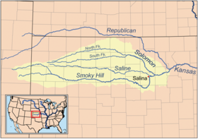
斯莫基希爾河流域圖,所羅門河位於中上部
國家美國
州份堪薩斯州
流域
源頭沃孔達湖(英語:Waconda Lake)
 • 位置米切爾縣考克城
 • 座標39°28′23″N 98°26′00″W[1]
 • 海拔1,453英尺(443公尺)
河口斯莫基希爾河
 • 位置介乎迪金森縣及薩林縣的所羅門
 • 座標38°54′13″N 97°22′09″W[1]
 • 海拔1,142英尺(348公尺)
流域面積6,835平方英里(17,700平方公里)
本貌
長度184英里(296公里)[1]
流量 
 • 平均流量555立方英尺每秒(15.7立方公尺每秒)[2]
 • 最小流量1立方英尺每秒(0.028立方公尺每秒)[2]
 • 最大流量157,000立方英尺每秒(4,400立方公尺每秒)[2]
关闭

所羅門河由所羅門河北汊(英語:North Fork Solomon River)及所羅門河南汊(英語:South Fork Solomon River)合流而成[4]。這兩條分汊均發源於堪薩斯州西北部的高地平原(英語:High Plains (United States)),並在米切爾縣西北部的沃孔達湖(英語:Waconda Lake)匯合[4][5][6]。離開沃孔達湖後,河水會往東南方流動,先後流經貝洛伊特(英語:Beloit, Kansas)、明尼阿波利斯及煙山(英語:Smoky Hills)地區,並在途中與多條溪流合流[1]。所羅門河最終在迪金森縣所羅門的南部與斯莫基希爾河匯合[4][1]。

所羅門河的流域面積為6,835平方英里(17,700平方公里),同時它亦屬於密西西比河流域的一部分[7]。

河流被當時沿河居住的美洲原住民稱為維斯卡帕拉河(Wiskapalla River),意為「鹹水」(Salt water)[1]。另有部份原住民稱河流為「Nepaholla」,意為「山上的水」,指的是位於河谷中的沃孔達溫泉(英語:Waconda Spring)[8]。1744年,法國探險家以著名的法屬路易斯安那官員埃德梅·加蒂安·德薩蒙(Edme Gatien de Salmon)來把河流命名為薩蒙河(Salmon River),但後來因錯誤的口耳相傳而變為現時的稱謂[9]。另外,河流亦有「Mahkineohe」、蘇西斯河(Rivière de Soucis)、所羅門溪及所羅門汊等稱呼[8]。

早在美國殖民之前,所羅門河山谷是大平原印第安人的熱門狩獵地點,而波尼族、夏延族及堪薩人(英語:Kaw people)則沿河設立營地[8]。1712年,法國探險家艾蒂安·文雅德·布爾格蒙特(英語:Étienne de Veniard, Sieur de Bourgmont)探索了該地區,並聲稱該地屬於法國[10]。1744年,一群法國探險家回到所羅門河山谷進行勘測,並為河流命名[10][8]。1803年,美國向法國購買法屬路易斯安那,自此所羅門河山谷便成為了美國領土的一部分。1806年,美國探險家紀伯倫·派克(英語:Zebulon Pike)帶領探險隊穿越所羅門河山谷,並在所羅門河北汊紮營[11]。1850年代,美國拓荒者開始移居至所羅門河山谷,並開始逐步建立城鎮[10]。1861年,該區域成為堪薩斯州的一部分[8]。

1944年,作為密蘇里河流域綜合發展計劃的一部分,格倫埃爾德水壩的興建方案在呈交至美國國會的參議院191號文件內被提及,用以滿足斯莫基希爾河流域的防洪和灌溉需求[12]。1951年7月中旬,連場大雨導致堪薩斯河、密蘇里河及其他周邊地區的水位大幅上升,最終洪水摧毀了堪薩斯州東部[13]。為了防止災難重演,美國墾務局及美國陸軍工兵部隊提出多項防洪方案,其中包括在所羅門河流經的格倫埃爾德附近興建水壩[14]。1969年,美國墾務局及美國陸軍工兵部隊完成格倫埃爾德水壩(Glen Elder Dam)及其水庫沃孔達湖(英語:Waconda Lake)的建設[15]。

一份2002年的研究確定所羅門河的流量會影響魚類的數量,指流量較低的河段(如位於柯溫水庫及韋伯斯特水庫上游的河段)其魚類數目較少[16]。同時,研究指出現時所羅門河流域內約有32%的本地物種消失,而在目前的魚類種群中約51%是由外來物種組成[16]。另外,有科研人員亦在流域內收集了河水、沉積物、大型無脊椎動物和魚類樣本,並進行硒濃度分析,發現所有樣本的硒含量均超過懷疑會造成魚類繁殖障礙的水平[17]。

  • 堪薩斯州河流列表
  • 斯莫基希爾河
  1. [1]
    Geographic Names Information System (GNIS). Solomon River. United States Geological Survey. 1978-10-13 [2020-09-19]. (原始內容存檔於2022-02-12) (英語).
  2. [2]
    U.S. Geological Survey. Water-Data Report-2012 - 06876900 Solomon River at Niles, KS (PDF). [2020-09-19]. (原始內容存檔 (PDF)於2019-06-28) (英語).
  3. [3]
    The National Map. National Hydrography Dataset high-resolution flowline data. U.S. Geological Survey. [2020-09-19]. (原始內容存檔於2012-04-05) (英語).
  4. [4]
    U.S. Bureau of Reclamation 1984,第5-8頁.
  5. [5]
    Geographic Names Information System (GNIS). North Fork Solomon River. 1978-10-13 [2020-09-19]. (原始內容存檔於2021-12-26) (英語).
  6. [6]
    Geographic Names Information System (GNIS). South Fork Solomon River. 1978-10-13 [2020-09-19]. (原始內容存檔於2023-11-06) (英語).
  7. [7]
    Kansas Water Office. Solomon River Basin (PDF). 2009 [2020-09-19]. (原始內容 (PDF)存檔於2011-06-03) (英語).
  8. [8]
    Von, Rothenberger. About the Solomon Valley. Solomon Valley/Highway 24 Heritage Alliance. 2002 [2020-09-19]. (原始內容存檔於2007-05-16) (英語).
  9. [9]
    Hall 1995,第8頁. sfn模板錯誤: 無指向目標: CITEREFHall1995 (幫助)
  10. [10]
    Schoewe, Walter H. The Geography of Kansas: Part III. Hydrogeography. Transactions of the Kansas Academy of Science. 1951, 54 (3): 263–329.
  11. [11]
    Scheffer, Theodore H. Following Pike's Expedition From the Smoky Hill to the Solomon. The Kansas Historical Quarterly. 1947, 14 (3): 240–247 [2020-09-19]. (原始內容存檔於2019-12-16).
  12. [12]
    U.S. Bureau of Reclamation. Glen Elder Unit. [2020-09-19]. (原始內容存檔於2020-08-23) (英語).
  13. [13]
    Associated Press. 1951 flood painting sells for nearly $1.9M in NYC. Fox News. 2011-05-19 [2020-09-19]. (原始內容存檔於2019-07-11) (英語).
  14. [14]
    U.S. Geological Survey. The 1951 Floods in Kansas Revisited (PDF). 2001 [2020-09-19]. (原始內容存檔 (PDF)於2017-03-01) (英語).
  15. [15]
    Rucker, Kevin E. Glen Elder Unit, Solomon Division, Pick-Sloan Missouri Basin Program. Bureau of Reclamation. 2001 [2020-09-19]. (原始內容存檔於2019-09-28) (英語).
  16. [16]
    Eberle, Mark E.; Hargett, Eric G.; Wenke, Thomas L.; Mandrak, Nicholas E. Changes in Fish Assemblages, Solomon River Basin, Kansas: Habitat Alterations, Extirpations, and Introductions. Transactions of the Kansas Academy of Science. 2002, 105 (3): 178–192.
  17. [17]
    May, Thomas W.; Fairchild, James F.; Petty, Jim D.; Walther, Michael J.; Lucero, Jeff; Delvaux, Mike; Manring, Jill; Armbruster, Mike. An evaluation of selenium concentrations in water, sediment, invertebrates, and fish from the Solomon River Basin. Environmental Monitoring and Assessment. 2008, 137: 213–232.
  • Hall, Gwendolyn Midlo. Africans in Colonial Louisiana: The Development of Afro-Creole Culture in the Eighteenth Century. Baton Rouge, LA: LSU Press. 1995. ISBN 978-0-8071-1999-0 (英語).
  • U.S. Bureau of Reclamation. Solomon River Basin Water Management Study, Kansas: Special Report. Washington, D.C.: U.S. Department of the Interior - Bureau of Reclamation. 1984 (英語).
  • Donald O. Whittemore, Determination of Waconda Lake Releases Needed for Diluting Saline Water in the Solomon River at Beloit for Municipal Water Supply. A Report Prepared for the Kansas Department of Agriculture, Division of Water Resources and Kansas Department of Health and Environment, Kansas Geological Survey. Open-File Report 2003-49.
  • Caldwell, Martha B. (編). Exploring the Solomon River Valley in 1869. The Kansas Historical Quarterly. 1937, 6 (1): 60–76 [2020-09-19]. (原始內容存檔於2019-12-16).
  • Scheffer, Theo. H. Old Fort Solomon at Lindsey. The Kansas Historical Quarterly. 1956, 22 (1): 342–346 [2020-09-19]. (原始內容存檔於2019-12-15).
Edit in WikipediaRevision historyRead in Wikipedia

Wikiwand in your browser!

Seamless Wikipedia browsing. On steroids.

Every time you click a link to Wikipedia, Wiktionary or Wikiquote in your browser's search results, it will show the modern Wikiwand interface.

Wikiwand extension is a five stars, simple, with minimum permission required to keep your browsing private, safe and transparent.

Chrome
Wikiwand for Chrome
Edge
Wikiwand for Edge
Firefox
Wikiwand for Firefox
热门问题
时间线
聊天
视角

流向及流域

命名

歷史

生態

另見

參考資料

文獻引用

延伸閱讀

faviconfavicon
2 sources
faviconfaviconfavicon
4 sources
faviconfaviconfaviconfaviconfavicon
7 sources
faviconfaviconfavicon
3 sources