File:World_1898_empires_colonies_territory.png
维基百科,自由的 encyclopedia
原始文件 (1,560 × 624像素,文件大小:45 KB,MIME类型:image/png)
| 描述World 1898 empires colonies territory.png |
|
||||||||||||||||
| 日期 | 2006年6月9日 (原始上传日期) | ||||||||||||||||
| 来源 | 无法识别来源。根据版权声明推断为其自己的作品。 | ||||||||||||||||
| 作者 | 无法识别作者。根据版权声明推断作者为Roke~commonswiki。 | ||||||||||||||||
.jpg)
._LOC_2001620596.jpg)

|
此historical map图片可使用矢量图形重新创建为SVG文件。这具有很多好处;更多信息请参见共享资源:待清理媒体。如果存在此图片的SVG格式,请将其上传,然后将此模板替换为
{{vector version available|新图片名称}}。
建议您将SVG命名为“World 1898 empires colonies territory.svg”,这样在使用Vector version available(或Vva)模板时就不需要填写新图片名称参数。 |
目录
摘要
Español
Imperios del mundo y sus colonias, (antes de la Guerra Española-Estadounidense, la Guerra de los Boxer y la Guerra de los Boer, derivado de Image:BlankMap-World-WWI.PNG
English
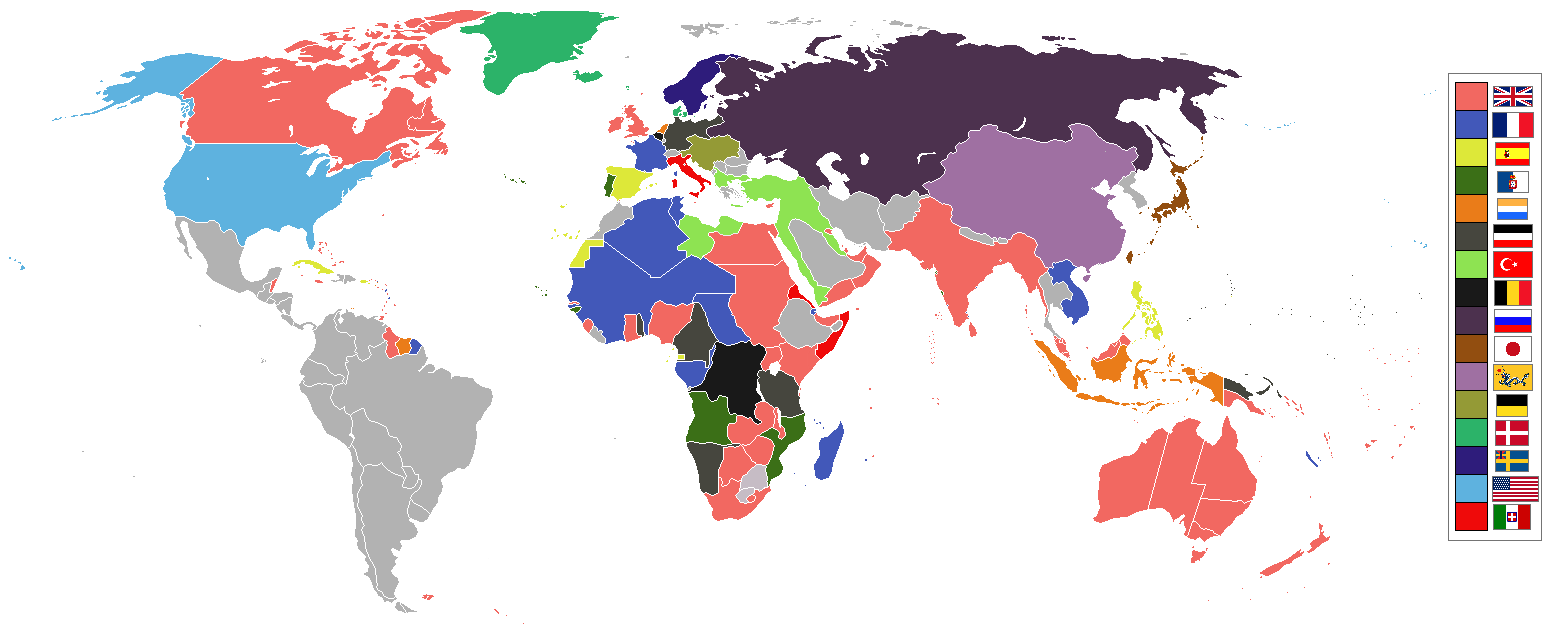
World empires and colonies 1898, (just before the Spanish–American War, Boxer Rebellion and Boer War), derived from Image:BlankMap-World-WWI.PNG
Tiếng Việt
Français
Empires et colonies du monde 1898, (juste avant la guerre hispano-américaine, la révolte des Boxers et la guerre des Boers, dérivée de Image:BlankMap-World-WWI.PNG).
عربي
مستوحاة من Image:BlankMap-World-WWI.PNG
中文 (繁體)
中文 (简体)
Deutsch
Italiano
Bahasa Indonesia
Imperium dan koloni di dunia pada tahun 1898 (sebelum Perang Spanyol-Amerika, Pemberontakan Boxer dan Perang Boer).
Македонски
Империи и колонии во 1898 г., (веднаш пред Шпанско-американската војна, Боксерското востание и Бурската војна), создадено врз основа на Image:BlankMap-World-WWI.PNG
Nederlands
Wereldrijken en kolonies 1898, (net voor de Spaans-Amerikaanse oorlog, Boxer opstand en Boerenoorlog).
Polski
Imperia i kolonie świata w 1898, (przed wojną amerykańsko-hiszpańską, powstaniem bokserów i wojnami burskimi), na podstawie Image:BlankMap-World-WWI.PNG
Português
Русский
Українська
한국어
1898년 세계의 각 제국과 국가들을 나타낸 지도이다. (미국-스페인 전쟁, 의화단 운동, 보어 전쟁 전의 상황이다.)
日本語
עברית
gurupletos
See also
| Maps of world history | |
| BC | |
|
| |
| AD |
1 · 50 · 100 · 200 · 250 · 300 · 400 · 500 · 700 · 750 · 820 · 900 · 1200 · 1500 · 1556 · 1648 · 1700 · 1750 · 1815 · 1859 · 1871 · 1914 · 1935 · 1954 · 1989 · 2000 · |
|
Maps of colonization history | |
|
see also: Eastern Hemisphere only maps template (1300BC-1500AD) | |
| (this template: · view · discuss ) | |
许可协议

|
已授权您依据自由软件基金会发行的无固定段落及封面封底文字(Invariant Sections, Front-Cover Texts, and Back-Cover Texts)的GNU自由文件许可协议1.2版或任意后续版本的条款,复制、传播和/或修改本文件。该协议的副本请见“GNU Free Documentation License”。http://www.gnu.org/copyleft/fdl.htmlGFDLGNU Free Documentation Licensetruetrue |
| 本文件采用知识共享署名-相同方式共享 3.0 未本地化版本许可协议授权。 | ||
| ||
| 本许可协议标签作为GFDL许可协议更新的组成部分被添加至本文件。http://creativecommons.org/licenses/by-sa/3.0/CC BY-SA 3.0Creative Commons Attribution-Share Alike 3.0truetrue |
| 注解 InfoField | 该图片含有注解:在维基媒体共享资源上查看注解 |
Capitanía General de Filipinas
说明
GNU自由文档许可证1.2或更高版本 简体中文(已转写)
知识共享署名-相同方式共享3.0未本地化版本 简体中文(已转写)
9 6 2006
image/png
文件历史
点击某个日期/时间查看对应时刻的文件。
| 日期/时间 | 缩略图 | 大小 | 用户 | 备注 | |
|---|---|---|---|---|---|
| 当前 | 2021年11月8日 (一) 09:16 | 1,560 × 624(45 KB) | Randomastwritter | jubaland | |
| 2019年7月3日 (三) 07:24 | 1,560 × 624(40 KB) | Insider | the border between East Africa Protectorate and Italian Somaliland per User talk:Insider#File:World 1898 empires colonies territory.png | ||
| 2019年1月31日 (四) 07:18 | 1,560 × 624(40 KB) | Insider | Arkticheskiy Institut Islands, Izvestiy TSIK Islands, Kirov Islands, Sverdrup Island, Russky Island, Uyedineniya Island, Vize Island and Ushakov Island also is terra nullis at 1898 | ||
| 2019年1月30日 (三) 10:34 | 1,560 × 624(40 KB) | Insider | In 1898, Grumant, Jan Mayen Island, Severnaya Zemlya, Franz Josef Land, Wrangel island was terra nullius. Fixed Aleutian and Solovki islands. | ||
| 2018年8月6日 (一) 15:56 | 1,560 × 624(45 KB) | Lord Obvious | |||
| 2016年4月12日 (二) 12:04 | 1,560 × 624(45 KB) | The- | Minor fixes | ||
| 2016年4月11日 (一) 21:59 | 1,560 × 624(45 KB) | The- | Minor fixes | ||
| 2016年4月11日 (一) 21:52 | 1,560 × 624(44 KB) | The- | More accurate map | ||
| 2014年8月3日 (日) 02:59 | 1,554 × 628(41 KB) | Alvin Lee | Correcting the boundaries of Russia and China | ||
| 2012年10月23日 (二) 18:36 | 1,554 × 628(62 KB) | Franco310397 | Spanish presence in Micronesia (Oceania) included in the Captaincy General of the Philippines. In the Caroline Islands and the Mariana Islands. |
文件用途
全域文件用途
以下其他wiki使用此文件:
- af.wikipedia.org上的用途
- als.wikipedia.org上的用途
- am.wikipedia.org上的用途
- an.wikipedia.org上的用途
- ar.wikipedia.org上的用途
- av.wikipedia.org上的用途
- az.wikipedia.org上的用途
- ba.wikipedia.org上的用途
- bg.wikipedia.org上的用途
- bn.wikipedia.org上的用途
- bs.wikipedia.org上的用途
- btm.wikipedia.org上的用途
- ca.wikipedia.org上的用途
- ceb.wikipedia.org上的用途
- ce.wikipedia.org上的用途
- cs.wikipedia.org上的用途
- da.wikipedia.org上的用途
- de.wikipedia.org上的用途
- de.wiktionary.org上的用途
- el.wikipedia.org上的用途
- en.wikipedia.org上的用途
查看此文件的更多全域用途。
元数据
此文件中包含有扩展的信息。这些信息可能是由数码相机或扫描仪在创建或数字化过程中所添加。
如果此文件的源文件已经被修改,一些信息在修改后的文件中将不能完全反映出来。
| 水平分辨率 | 47.24 dpc |
|---|---|
| 垂直分辨率 | 47.24 dpc |
| 文件修改日期时间 | 2019年7月3日 (三) 07:23 |