File:Le_Neptune_françois,_ou_Atlas_nouveau_des_cartes_marines_(P._Mortier).pdf
З Вікіпедії, безкоштовно encyclopedia


Повна роздільність (1514 × 1910 пікселів, розмір файлу: 34,79 МБ, MIME-тип: application/pdf, 54 сторінки)
| Відомості про цей файл містяться на Вікісховищі — централізованому сховищі вільних файлів мультимедіа для використання у проектах Фонду Вікімедіа. |
Опис файлу
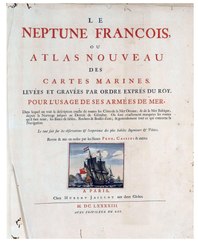
| Pieter Mortier I: Le Neptune françois, ou atlas nouveau des cartes marines
|
||||||||||||||||||||||||
|---|---|---|---|---|---|---|---|---|---|---|---|---|---|---|---|---|---|---|---|---|---|---|---|---|
| Автор |
author QS:P50,Q7192808 |
 | ||||||||||||||||||||||
| Заголовок |
Le Neptune françois, ou atlas nouveau des cartes marines |
|||||||||||||||||||||||
| Підзаголовок | leveés et gravées par ordre exprés du Roy, pour la usage de ses armées de mer dans lequel on voit la description exacte de toutes les côtes de la Mer Oceane, & de la Mer Baltique, depuis la Norwege au Detroit de Gibraltar. Où sont exactement marquées les routes quail faut tenir, les bancs de sables, rochers & brasses daeau ; & generalement tout ce qui concerne la navigation / reveu et mis en meilleur ordre par les Sieurs Pene, Cassini & autres | |||||||||||||||||||||||
| Номер тома | 1 | |||||||||||||||||||||||
| Видавництво |
creator QS:P170,Q7192808 [sic.Chez Hubert Jaillot] |
|||||||||||||||||||||||
| Опис |
English: This is one of the editions of the Dutch counterfeit atlas "Neptune François", originally published in Paris in 1693. The Dutch editions have the false address "A Paris: Chez Hubert Jaillot, aux deux globes", with Jaillot never being responsible for the publication and sale of this atlas. The French maps were copied and re-recorded in Amsterdam by R. de Hooghe. We are probably facing ed. M.Mor 3, according to Koeman. Maps 2, 5, 7, 9, 14 and 25 have the printing address "A Amsterdam, Chez Pierre Mortier", while maps 4, 8, 12, 13, 16, 17, 18, 22 and 27 have the indication "To Amsterdam, Chez Pierre Mortier et compagnie"
Date attributed based on the fact that an important part of the maps bear the mention "A Amsterdam, Chez Pierre Mortier et compagnie" which started to be used from 1719, after the death of Pierre Mortier's widow.
Português: Trata-se de umas das edições da contrafacção holandesa do atlas "Neptune François", originalmente publicado em Paris, em 1693. As edições holandesas apresentam o endereço falso "A Paris : Chez Hubert Jaillot, aux deux globes", sendo que Jaillot nunca foi o responsável pela publicação e venda deste atlas. Os mapas franceses foram copiados e regravados em Amesterdão por R. de Hooghe. Estamos, provavelmente, perante a ed. M.Mor 3, segundo Koeman. Os mapas 2, 5, 7, 9, 14 e 25 apresentam o endereço de impressão "A Amsterdam, Chez Pierre Mortier", enquanto os mapas 4, 8, 12, 13, 16, 17, 18, 22 e 27 apresentam a indicação "A Amsterdam, Chez Pierre Mortier et compagnie"
Data atribuída com base no facto de uma parte importante dos mapas terem a menção "A Amsterdam, Chez Pierre Mortier et compagnie" que passou a ser usada a partir de 1719, após a morte da viúva de Pierre Mortier. |
|||||||||||||||||||||||
| Мова | французька | |||||||||||||||||||||||
| Дата публікації |
після 1719 publication_date QS:P577,+1719-00-00T00:00:00Z/7,P1319,+1719-00-00T00:00:00Z/9 |
|||||||||||||||||||||||
| Місце видання | Амстердам [sic. Париж] | |||||||||||||||||||||||
| Джерело | Biblioteca Nacional de Portugal (BNP catalog entry) | |||||||||||||||||||||||
Ліцензування
| Public domainPublic domainfalsefalse |
|
Ця робота перебуває у суспільному надбанні у країнах і територіях, де авторське право охороняється протягом життя автора та 70 років після того або менше. Ця робота перебуває у суспільному надбанні у Сполучених Штатах, оскільки вона була опублікована (або зареєстрована у U.S. Copyright Office) до 1 січня 1929 року. | |
| Цей файл визнано вільним від відомих обмежень з боку закону про авторські права, включаючи всі пов'язані і суміжні права. | |
https://creativecommons.org/publicdomain/mark/1.0/PDMCreative Commons Public Domain Mark 1.0falsefalse
Історія файлу
Клацніть на дату/час, щоб переглянути, як тоді виглядав файл.
| Дата/час | Мініатюра | Розмір об'єкта | Користувач | Коментар | |
|---|---|---|---|---|---|
| поточний | 16:48, 16 березня 2021 |  | 1514 × 1910, 54 сторінки (34,79 МБ) | Giro720 | {{Book |Author = {{Creator:Pieter Mortier}} |Translator = |Editor = |Illustrator = |Title = Le Neptune françois, ou atlas nouveau des cartes marines |Subtitle = dans lequel on voit la description exacte de toutes les côtes du monde, du Détroit de Gibraltar, de la Mer Oceane Meridionale ou Ethiopiene, de la Mer des Indes, Orientales, & Occidentales &c. Où sont exactement marquées les routes quªil faut tenir, les bancs de sables, rochers & brasses dªeau; & generalement tout ce qui conc... |
Використання файлу
Нема сторінок, що використовують цей файл.
Метадані
Файл містить додаткові дані, які зазвичай додаються цифровими камерами чи сканерами. Якщо файл редагувався після створення, то деякі параметри можуть не відповідати цьому зображенню.
| Коротка назва | Untitled |
|---|---|
| Програмне забезпечення | LuraDocument PDF Compressor Server 5.8.72.50 (original: unknown) |
| програма конвертації | GPL Ghostscript 9.07 |
| Зашифровано | no |
| Розмір сторінки |
|
| Версія формату PDF | 1.4 |