File:South_Africa_Districts_April_2006.png
From Wikipedia, the free encyclopedia
Андозаи ин пешнамоиш: 800 × 581 пиксел. Дигар кайфиятҳо: 320 × 232 пиксел | 640 × 464 пиксел | 1 024 × 743 пиксел | 1 141 × 828 пиксел.
Акси аслӣ ((1 141 × 828 пиксел, ҳаҷми парванда: 38 кбайт, навъи MIME: image/png))
Ин файл аз Викианбор ва дар дигар лоиҳаҳо метавонад истифода шавад. Тафсилоти ин файл саҳифаи тафсилоти файл дар зер нишон дода шудааст.

|
This locator map image could be re-created using vector graphics as an SVG file. This has several advantages; see Commons:Media for cleanup for more information. If an SVG form of this image is available, please upload it and afterwards replace this template with
{{vector version available|new image name}}.
It is recommended to name the SVG file “South Africa Districts April 2006.svg”—then the template Vector version available (or Vva) does not need the new image name parameter. |
Хулоса
| ТавсифотSouth Africa Districts April 2006.png |
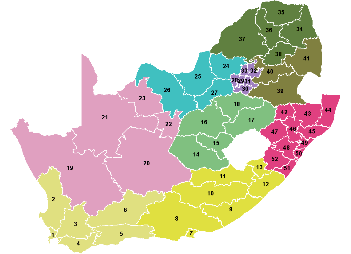
Map showing the 52 districts of South Africa. Colours indicate the 9 provinces. Created by Wayne Dam using data from the Municipal Demarcation Board after the 12th amendment to the Constitution. |
| Сана | |
| Манбаъ | Created by me from Shapefile data from the Municipal Demarcation Board, South Africa. |
| Муаллиф | Wayne Dam (User:Waynedam) |
| Иҷозат (Пешроҳандозии ин парванда) |
Dual-licensed under the GFDL and CC-By-SA-2.5, 2.0, and 1.0. |
Иҷозатнома
I, the copyright holder of this work, hereby publish it under the following licenses:

|
Permission is granted to copy, distribute and/or modify this document under the terms of the GNU Free Documentation License, Version 1.2 or any later version published by the Free Software Foundation; with no Invariant Sections, no Front-Cover Texts, and no Back-Cover Texts. A copy of the license is included in the section entitled GNU Free Documentation License.http://www.gnu.org/copyleft/fdl.htmlGFDLGNU Free Documentation Licensetruetrue |
| This file is licensed under the Creative Commons Attribution-Share Alike 3.0 Unported license. | ||
| ||
| This licensing tag was added to this file as part of the GFDL licensing update.http://creativecommons.org/licenses/by-sa/3.0/CC BY-SA 3.0Creative Commons Attribution-Share Alike 3.0truetrue |
This file is licensed under the Creative Commons Attribution-Share Alike 2.5 Generic, 2.0 Generic and 1.0 Generic license.
- Шумо озодед:
- мубодилот намудан – копӣ, паҳн ва фиристадани асар
- ремикс кардан – татбиқи кор
- Under the following conditions:
- тахсис – You must give appropriate credit, provide a link to the license, and indicate if changes were made. You may do so in any reasonable manner, but not in any way that suggests the licensor endorses you or your use.
- саҳми яксон – If you remix, transform, or build upon the material, you must distribute your contributions under the same or compatible license as the original.
Шумо иҷозатномаи хостаи худро интихоб карда метавонед.
Captions
Add a one-line explanation of what this file represents
Mapa das 9 provincias e 52 distritos de Suráfrica a partir da décimo segunda emenda da Constitución.
Items portrayed in this file
тавсифҳо
copyrighted Англисӣ
23 апрели 2006
Таърихи файл
Рӯи таърихҳо клик кунед то нусхаи марбути парвандаро бубинед.
| Таърих | Бандангуштӣ | Андоза | Корбар | Тавзеҳ | |
|---|---|---|---|---|---|
| нусхаи феълӣ | 21:04, 15 апрели 2006 | | 1 141 × 828 (38 кбайт) | Waynedam | Map showing the 52 districts of South Africa. Colours indicate the 9 provinces. Created by Wayne Dam using data from the Municipal Demarcation Board after the 12th amendment to the Constitution. |
Пайвандҳо
Ин акс дар ҳеҷ саҳифа истифода намешавад.
Истифодаи саросарии парванда
Викиҳои дигари зерин ин файлро истифода мекунанд:
- Истифода дар als.wikipedia.org
- Истифода дар bar.wikipedia.org
- Истифода дар bg.wikipedia.org
- Истифода дар ca.wikipedia.org
- Истифода дар dsb.wikipedia.org
- Истифода дар en.wikipedia.org
- Истифода дар eo.wikipedia.org
- Истифода дар fi.wikipedia.org
- Истифода дар frr.wikipedia.org
- Истифода дар gl.wikipedia.org
- Истифода дар hu.wikipedia.org
- Истифода дар id.wikipedia.org
- Истифода дар it.wikipedia.org
- Истифода дар ja.wikipedia.org
- Истифода дар lt.wikipedia.org
- Истифода дар mr.wikipedia.org
- Истифода дар nl.wikipedia.org
- Истифода дар nov.wikipedia.org
- Истифода дар pl.wikipedia.org
- Истифода дар pt.wikipedia.org
- Истифода дар rm.wikipedia.org
- Истифода дар ro.wikipedia.org
- Истифода дар sw.wikipedia.org
- Истифода дар tn.wikipedia.org
- Истифода дар tr.wikipedia.org