Датотека:Aksai_Chin_Sino-Indian_border_map.png
From Wikipedia, the free encyclopedia
Оригинална датотека (624 × 872 пиксела, величина датотеке: 102 kB, MIME тип: image/png)
| Ово је датотека са Викимедијине оставе. Информације са њене странице са описом приказане су испод. Викимедијина остава је складиште слободно лиценциралних мултимедијалних датотека. И Ви можете да помогнете. |
Опис


| ОписAksai Chin Sino-Indian border map.png |
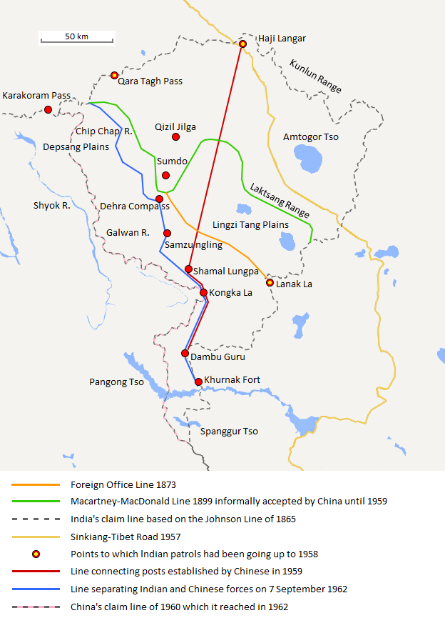
English: The map shows the Indian and Chinese claims of the border in the Aksai Chin region, the Macartney-MacDonald line, the Foreign Office Line, as well as the progress of Chinese forces as they occupied areas during the Sino-Indian War. |
| Датум | |
| Извор | Сопствено дело |
| Аутор | The Discoverer |
The Macartney-MacDonald line is described as follows: "From the Karakoram Pass the crests of the range run nearly east for about half a degree, and then turn south to a little below the 35th parallel.. Rounding... the source of the Karakash, the line of hills to be followed runs north-east to a point east of Kizil Jilga and from there, in a south-easterly direction, follows the Lak Tsung (Lokzhung) Range until that meets a spur.. which has hitherto been shown on our maps as the eastern boundary of Ladakh.[1]
The Macartney-MacDonald line was never accepted by China, although they informally indicated acceptance on certain occasions:
- Woodman, Dorothy (1969) Himalayan Frontiers: A Political Review of British, Chinese, Indian, and Russian Rivalries, Praeger, p. 102 „The proposed boundary seems never to have been considered in the same form again until Alastair Lamb revived it in 1964.“
- Lamb, Alastair (1965). "Treaties, Maps and the Western Sector of the Sino-Indian Boundary Dispute". The Australian Year Book of International Law. "Unfortunately, the Chinese never replied formally to the note, though they indicated informally on a number of occasions their agreement as to its boundary alignment."
In 1959, Chou confirmed the new Chinese claim line to Nehru.
References: [2] archive copy at the Wayback Machine [3] [4] [5] [6] Map on last page archive copy at the Wayback Machine [7]
Лиценцирање
- Дозвољено је:
- да делите – да умножавате, расподељујете и преносите дело
- да прерађујете – да прерадите дело
- Под следећим условима:
- ауторство – Морате да дате одговарајуће заслуге, обезбедите везу ка лиценци и назначите да ли су измене направљене. Можете то урадити на било који разуман манир, али не на начин који предлаже да лиценцатор одобрава вас или ваше коришћење.
- делити под истим условима – Ако измените, преобразите или доградите овај материјал, морате поделити своје доприносе под истом или компатибилном лиценцом као оригинал.
Натписи
Ставке приказане у овој датотеци
приказује
Нека вредност без ставке на Википодаци
27. август 2013
image/png
f6428074bd2a63fcdca4d1c78d6e29848885a399
104.131 бајт
872 пиксел
624 пиксел
Историја датотеке
Кликните на датум/време да бисте видели тадашњу верзију датотеке.
| Датум/време | Минијатура | Димензије | Корисник | Коментар | |
|---|---|---|---|---|---|
| тренутна | 22:06, 7. септембар 2020. | | 624 × 872 (102 kB) | The Discoverer | Removed Tibet-Sinkiang boundary, added label for Amtogor Tso. |
| 04:51, 9. јун 2020. |  | 624 × 872 (102 kB) | MarkH21 | Intended change from the last edit (i.e. latest version with "informally" per references in talk discussion) | |
| 04:29, 9. јун 2020. |  | 624 × 872 (101 kB) | MarkH21 | Reverted to version as of 00:21, 7 February 2018 (UTC) This was the previous version; the addition of “accepted by China until 1959” was the contested change, not the revert to the original description (the refs are also now dead, but previously said tacit acceptance which isn’t outright acceptance) | |
| 21:37, 23. април 2018. |  | 624 × 872 (102 kB) | The Discoverer | Reverted to version as of 09:10, 13 December 2017 (UTC) The file of 12 December removes a statement that is supported by the source. As per COM:OVERWRITE, "Controversial or contested changes should be uploaded to a separate filename" | |
| 02:21, 7. фебруар 2018. |  | 624 × 872 (101 kB) | 樂號 | Reverted to version as of 23:05, 12 December 2017 (UTC) | |
| 11:10, 13. децембар 2017. |  | 624 × 872 (102 kB) | The Discoverer | Reverted to version as of 11:07, 19 February 2017 (UTC) The file of 12 December removes a statement that is supported by the source. As per COM:OVERWRITE, "Controversial or contested changes should be uploaded to a separate filename" | |
| 01:05, 13. децембар 2017. |  | 624 × 872 (101 kB) | 樂號 | Macartney–MacDonald Line is only proposed by Britain No official accept made by China | |
| 13:07, 19. фебруар 2017. |  | 624 × 872 (102 kB) | The Discoverer | Added Karakoram Pass and Kunlun Range | |
| 17:26, 1. април 2015. |  | 624 × 872 (59 kB) | RokerHRO | optipng -o7 -i0 → 40.77% decrease | |
| 17:00, 2. октобар 2014. |  | 624 × 872 (99 kB) | The Discoverer | Uploaded correct file with scale added. |
Употреба датотеке
Следећа страница користи ову датотеку:
Глобална употреба датотеке
Други викији који користе ову датотеку:
- Употреба на ast.wikipedia.org
- Употреба на as.wikipedia.org
- Употреба на az.wikipedia.org
- Употреба на bh.wikipedia.org
- Употреба на bn.wikipedia.org
- Употреба на ca.wikipedia.org
- Употреба на de.wikipedia.org
- Употреба на en.wikipedia.org
- Употреба на es.wikipedia.org
- Употреба на fr.wikipedia.org
- Употреба на hi.wikipedia.org
- Употреба на id.wikipedia.org
- Употреба на it.wikipedia.org
- Употреба на ja.wikipedia.org
- Употреба на ka.wikipedia.org
- Употреба на kn.wikipedia.org
- Употреба на ko.wikipedia.org
- Употреба на lv.wikipedia.org
- Употреба на ml.wikipedia.org
- Употреба на ms.wikipedia.org
- Употреба на nl.wikipedia.org
- Употреба на no.wikipedia.org
- Употреба на or.wikipedia.org
- Употреба на pl.wikipedia.org
- Употреба на pt.wikipedia.org
- Употреба на ro.wikipedia.org
- Употреба на ru.wikipedia.org
- Употреба на ru.wikinews.org
- Употреба на ta.wikipedia.org
- Употреба на te.wikipedia.org
- Употреба на uk.wikipedia.org
- Употреба на vi.wikipedia.org
Још глобалног коришћења ове датотеке.
Метаподаци
Ова датотека садржи додатне податке, који вероватно долазе од дигиталног фотоапарата или скенера коришћеног за дигитализацију.
Ако је првобитно стање датотеке промењено, могуће је да неки детаљи не описују измењену датотеку у потпуности.
| Водоравна резолуција | 37,8 тпц |
|---|---|
| Вертикална резолуција | 37,8 тпц |