The Washington Metro is a rapid transit system that serves the Washington, D.C. metropolitan area in the United States. It has the second busiest rapid transit system in the United States.[2] The New York City Subway is the busiest.
Quick facts Overview, Locale ...
| Washington Metro |
|---|
 |
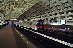 Washington Metro's Farragut West station in April 2018 |
|
| Locale | Washington metropolitan area |
|---|
| Transit type | Rapid transit |
|---|
| Number of lines | 6 |
|---|
| Line number | |
|---|
| Number of stations | 98 |
|---|
| Daily ridership | 474,000 (weekdays, 2023) |
|---|
| Chief executive | Randy Clarke |
|---|
| Headquarters | 600 5th Street NW
Washington, D.C., U.S. |
|---|
| Website | www.wmata.com/service/rail/ |
|---|
|
| Began operation | March 27, 1976; 49 years ago (1976-03-27) |
|---|
| Operator(s) | Washington Metropolitan Area Transit Authority (WMATA) |
|---|
| Character | At-grade, elevated, and underground |
|---|
| Number of vehicles | 1,318 railcars |
|---|
| Train length | 6 or 8 cars |
|---|
| Headway | 6–12 mins peak; 6–15 mins off-peak |
|---|
|
| System length | 129 mi (208 km) |
|---|
| No. of tracks | 2 |
|---|
| Track gauge | 4 ft 8 1⁄4 in (1,429 mm)[1] |
|---|
| Minimum radius of curvature | 225 ft (68.6 m)[1] |
|---|
| Electrification | Third rail, 750 V DC |
|---|
| Average speed | 33 mph (53 km/h) |
|---|
| Top speed | 75 mph (121 km/h) (design)
59 mph (95 km/h)-65 mph (105 km/h) (service) |
|---|
 Show interactive map
 Show static map
|
| Ashburn |
|
|
|
|
| Loudoun Gateway |
|
|
|
|
Dulles Yard |
|
|
|
|
| Dulles International Airport |
|
|
|
|
| Innovation Center |
|
|
|
|
| Herndon |
|
|
|
|
| Reston Town Center |
|
|
|
|
| Wiehle–Reston East |
|
|
|
Shady Grove Yard |
| Spring Hill |
|
|
|
Shady Grove |
| Greensboro |
|
|
|
Rockville |
|
|
|
|
Twinbrook |
| Tysons |
|
|
|
|
| McLean |
|
|
|
North Bethesda |
| Vienna |
|
|
|
Grosvenor–Strathmore |
| Dunn Loring |
|
|
|
Glenmont Yard |
| Medical Center |
|
|
|
Glenmont |
Falls Church Yard |
|
|
|
Greenbelt Yard |
| West Falls Church |
|
|
|
Greenbelt |
| East Falls Church |
|
|
|
Wheaton |
| Ballston–MU |
|
|
|
College Park |
| Bethesda |
|
|
|
Forest Glen |
| Virginia Square–GMU |
|
|
|
Hyattsville Crossing |
| Friendship Heights |
|
|
|
Silver Spring |
| Tenleytown–AU |
|
|
|
West Hyattsville |
| Clarendon |
|
|
|
Takoma |
| Van Ness–UDC |
|
|
|
Fort Totten |
| Court House |
|
|
|
Georgia Avenue–Petworth |
| Cleveland Park |
|
|
|
Columbia Heights |
| Woodley Park |
|
|
|
Brookland–CUA |
| Dupont Circle |
|
|
|
Rhode Island Avenue |
| Rosslyn |
|
|
|
Brentwood Yard |
| Foggy Bottom–GWU |
|
|
|
NoMa–Gallaudet U |
| Farragut North |
|
|
|
Union Station |
|
| Farragut West |
|
|
|
U Street |
|
|
|
|
Shaw–Howard University |
| Arlington Cemetery |
|
|
|
Mount Vernon Square |
| McPherson Square |
|
|
|
Judiciary Square |
| Metro Center |
|
|
|
Gallery Place |
| Federal Triangle |
|
|
|
|
| Smithsonian |
|
|
|
Archives |
|
|
|
|
L'Enfant Plaza |
|
|
|
|
Federal Center SW |
| Waterfront |
|
|
|
Capitol South |
| Navy Yard–Ballpark |
|
|
|
Eastern Market |
| Anacostia |
|
|
|
Potomac Avenue |
| Congress Heights |
|
|
|
Stadium–Armory |
| Pentagon |
|
|
|
|
| Pentagon City |
|
|
|
Minnesota Avenue |
| Crystal City |
|
|
|
Benning Road |
| Southern Avenue |
|
|
|
Deanwood |
| National Airport |
|
|
|
Cheverly |
| Naylor Road |
|
|
|
Capitol Heights |
| Suitland |
|
|
|
Addison Road |
| Branch Avenue |
|
|
|
Landover |
Branch Avenue Yard |
|
|
|
New Carrollton |
| Potomac Yard |
|
|
|
Morgan Boulevard |
| Braddock Road |
|
|
|
New Carrollton Yard |
| King Street–Old Town |
|
|
|
Downtown Largo |
|
|
|
|
|
Alexandria Yard |
|
|
|
|
| Van Dorn Street |
|
|
|
Eisenhower Avenue |
| Franconia–Springfield |
|
|
|
Huntington |
|
|
|
|
|
|
|
|
Key |
| Red Line |
|
|
|
Green Line |
| Orange Line |
|
|
|
Yellow Line |
| Blue Line |
|
|
|
Silver Line |
| Multiple services |
|
|
|
Non-revenue tracks |
All stations are accessible |
|
|
|
|
|
|
|
|
|
Show route diagram map | |
Close

Cleveland Park Metro station
(Red Line)
 Actual map of the Washington Metro. Map of the network is drawn to scale.

_052.jpg)


.svg)