Utica, New York
city in Oneida County, New York, United States From Wikipedia, the free encyclopedia
city in Oneida County, New York, United States From Wikipedia, the free encyclopedia
Utica (/ˈjuːtɪkə/ (![]() listen)) is a city in the Mohawk Valley and the county seat of Oneida County, New York, United States. Its population was 65,283 in the 2020 U.S. census.[6]
listen)) is a city in the Mohawk Valley and the county seat of Oneida County, New York, United States. Its population was 65,283 in the 2020 U.S. census.[6]
Utica, New York | |
|---|---|
|
Clockwise from top: Panorama of downtown from I-790, Looking south on Utica's Genesee Street, Utica Tower and harbor lock, Union Station, Adirondack Bank Center, Liberty Bell Corner, Stanley Theater | |
| Nickname(s): The Handshake City, Sin City, Elm Tree City[1] | |
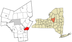
 Location in Oneida County and New York | |
| Coordinates: 43°06′03″N 75°13′57″W | |
| Country | United States |
| State | New York |
| Region | Central New York; Mohawk Valley |
| Metro | Utica–Rome |
| County | Oneida |
| Land grant (village) | January 2, 1734[2] |
| Incorporated (village) | April 3, 1798[3] |
| Incorporated (city) | February 13, 1832[4] |
| Government | |
| • Type | Strong mayor-council |
| Area | |
| • City | 16.98 sq mi (43.97 km2) |
| • Land | 16.72 sq mi (43.31 km2) |
| • Water | 0.26 sq mi (0.66 km2) |
| Elevation | 456 ft (139 m) |
| Population | |
| • City | 65,283 |
| • Density | 3,904.0/sq mi (1,507.3/km2) |
| • Urban | 119,059 (U.S.: 282nd) |
| • Metro | 292,264 (U.S.: 171st) |
| Demonym | Utican |
| Time zone | UTC−5 (Eastern (EST)) |
| • Summer (DST) | UTC−4 (EDT) |
| ZIP Codes | 13501-13505, 13599 |
| Area code | 315 |
| FIPS code | 36-76540 |
| GNIS feature ID | 0968324[7] |
| Website | cityofutica.com |
It is located on the Mohawk River at the foot of the Adirondack Mountains. Utica is about 90 miles (145 km) northwest of Albany and 45 miles (72 km) east of Syracuse. Utica and the nearby city of Rome anchor the Utica–Rome Metropolitan Statistical Area, which makes up all of Oneida and Herkimer counties.
Seamless Wikipedia browsing. On steroids.
Every time you click a link to Wikipedia, Wiktionary or Wikiquote in your browser's search results, it will show the modern Wikiwand interface.
Wikiwand extension is a five stars, simple, with minimum permission required to keep your browsing private, safe and transparent.