Saba
island in the Caribbean, part of the Netherlands From Wikipedia, the free encyclopedia
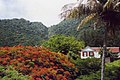
Saba (spoken as "Sah-ba") is the smallest island of the Caribbean Netherlands and the former Netherlands Antilles. It is a special municipality (public body) of the Netherlands. It lies at 17°38′N 63°14′W. It is mostly made up of Mount Scenery (877 m), the highest point of the Kingdom of the Netherlands. Scenery is a dormant volcano.
Saba | |
|---|---|
Special municipality of the Netherlands | |
 Flag  Coat of arms | |
| Motto(s): | |
| Anthem: "Saba you rise from the ocean" | |
 | |
 Map showing location of Saba relative to Sint Eustatius and Saint Martin. | |
| Coordinates: 17°37′57″N 63°14′15″W | |
| Country | Netherlands |
| Overseas region | Caribbean Netherlands |
| Incorporated into the Netherlands | 10 October 2010 (dissolution of the Netherlands Antilles) |
| Capital (and largest city) | The Bottom |
| Government | |
| • Lt. Governor | Jonathan Johnson |
| Area | |
| • Total | 13 km2 (5 sq mi) |
| Population (1 January 2022)[2] | |
| • Total | 1,911 |
| • Density | 148/km2 (380/sq mi) |
| Demonym | Saban |
| Languages | |
| • Official | Dutch |
| • Recognised regional | English[3] |
| Ethnicity | |
| • Saban | 26.6 % |
| • Sint Maarten | 15.7 % |
| • American | 10.0 % |
| • other | 47.7 % |
| Time zone | UTC−4 (AST) |
| Calling code | +599-4 |
| ISO 3166 code | BQ-SA, NL-BQ2 |
| Currency | United States dollar ($) (USD) |
| Internet TLD | |
Saba has a land area of 13 km² (5 sq. miles). At the 2001 Netherlands Antilles census, 1,349 people lived there. In 2004, about 1,424 people lived there.
Gallery
 Hawksbill Turtle
 Saba's airport


Notes
References
Other websites
Wikiwand - on
Seamless Wikipedia browsing. On steroids.