Rettenberg
municipality in the district of Oberallgäu in Bavaria, Germany From Wikipedia, the free encyclopedia
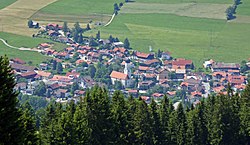
Rettenberg is a municipality in the district of Oberallgäu in Bavaria in Germany. Rettenberg is twinned with the village La Frénaye in Northern France (close to Le Havre). Rettenberg is the southernmost village with breweries (Engelbräu and Zötlerbrauerei) in Germany.

Rettenberg | |
|---|---|
 Rettenberg | |
| Coordinates: 47°35′N 10°18′E | |
| Country | Germany |
| State | Bavaria |
| Admin. region | Schwaben |
| District | Oberallgäu |
| Government | |
| • Mayor | Oliver Kunz (since 1.May 2008) (CSU) |
| Area | |
| • Total | 60.08 km2 (23.20 sq mi) |
| Elevation | 805 m (2,641 ft) |
| Population (2022-12-31)[1] | |
| • Total | 4,601 |
| • Density | 77/km2 (200/sq mi) |
| Time zone | UTC+01:00 (CET) |
| • Summer (DST) | UTC+02:00 (CEST) |
| Postal codes | 87549 |
| Dialling codes | 08327 |
| Vehicle registration | OA |
| Website | www.rettenberg.de |
References
Wikiwand - on
Seamless Wikipedia browsing. On steroids.


