Republican River
river in Kansas and Nebraska in the United States From Wikipedia, the free encyclopedia
river in Kansas and Nebraska in the United States From Wikipedia, the free encyclopedia
The Republican River is a river in the central Great Plains area of North America. It starts in the High Plains of eastern Colorado, and it goes east 453 miles (729 km)[4] through the U.S. states of Nebraska and Kansas.
| Republican River Forche des Republiques, [1] Coster Blanches, Ki-ra-ru-tah, Mahohevaohe[2] | |
|---|---|
 The Republican River near Riverton, Nebraska | |
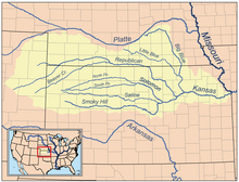
 Map of the Kansas River drainage basin showing the Republican River | |
| Location | |
| Country | United States |
| States | Nebraska, Kansas |
| Physical characteristics | |
| Source confluence | |
| - location | Haigler, Nebraska |
| - coordinates | 40°01′12″N 101°56′16″W[2] |
| - elevation | 3,253 ft (992 m) |
| Mouth | Kansas River |
| - location | Junction City, Kansas |
| - coordinates | 39°03′36″N 98°48′05″W[2] |
| - elevation | 1,043 ft (318 m) |
| Length | 453 mi (729 km) |
| Basin size | 24,900 sq mi (64,000 km2) |
| Discharge | |
| - location | Junction City about 3 mi (4.8 km) above the mouth[3] |
| - average | 848 cu ft/s (24.0 m3/s) |
| - minimum | 3.2 cu ft/s (0.091 m3/s) |
| - maximum | 33,300 cu ft/s (940 m3/s) |
| Basin features | |
| Tributaries | |
| - left | North Fork Republican River, Frenchman Creek, Red Willow Creek, Medicine Creek |
| - right | Arikaree River, South Fork Republican River, Sappa Creek, Prairie Dog Creek, White Rock Creek |
| Watersheds | Republican-Kansas-Missouri-Mississippi |
Seamless Wikipedia browsing. On steroids.
Every time you click a link to Wikipedia, Wiktionary or Wikiquote in your browser's search results, it will show the modern Wikiwand interface.
Wikiwand extension is a five stars, simple, with minimum permission required to keep your browsing private, safe and transparent.