Pilbara
administrative region of Western Australia From Wikipedia, the free encyclopedia
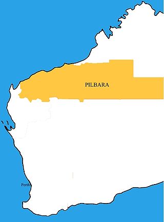
The Pilbara is a large, thinly populated region in the north of Western Australia.[1][2] In 2010, the region had a population of about 48,600.[3][4]
Pilbara | |
|---|---|
 The Pilbara region according to the Regional Development Commissions Act 1993 | |
| Coordinates: 21°S 119°E | |
| Country | Australia |
| state | Western Australia |
| Area | |
| • Total | 502,000 km2 (194,000 sq mi) |
| Population (2010) | |
| • Total | 48,610 |
| • Density | 0.097/km2 (0.25/sq mi) |


Pilbara is known for Aboriginal peoples, its stunning landscapes, its red earth and its vast mineral deposits, in particular iron ore. It is a dry region, but it has cyclones every year or two. The cyclones bring a great deal of rain when they do occur.
The area is known for its petroleum, natural gas and iron ore deposits, which make up much of the economy of Western Australia. Other than mining, pastoral activities as well as fishing and tourism are the main industries.[5]
The Pilbara covers an area of 502,000 square kilometres (194,000 square miles).[6] It includes some of Earth's oldest rock formations in the Pilbara craton. This is one of the world's oldest undisturbed rock formations, dating back to the Archaean eon. It includes landscapes of coastal plains and mountain ranges with cliffs and gorges. The major settlements of the region are Port Hedland, Karratha and Newman.
The Pilbara includes the two of the largest national parks in Australia:
- Karlamilyi National Park
- Karijini National Park
References
Wikiwand - on
Seamless Wikipedia browsing. On steroids.
