Inagua
island From Wikipedia, the free encyclopedia
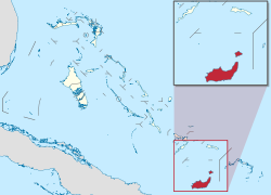
Inagua is the southernmost district of the Bahamas. It is the islands of Great Inagua and Little Inagua.
District of Inagua | |
|---|---|
District | |
 | |
| Coordinates: 25°4′N 77°20′W | |
| Country | Bahamas |
| Island | Great Inagua |
| Established | 1999 |
| Government | |
| • Type | District Council |
| • Chief Councillor | Francoinn Cox |
| • Deputy Chief Councillor | Colin Ingraham |
| Area | |
| • Total | 1,679 km2 (648 sq mi) |
| Population (2008) | |
| • Total | ~1,000 |
| • Density | 0.59/km2 (1.5/sq mi) |
| Time zone | UTC−5 (EST) |
| • Summer (DST) | UTC−4 (EDT) |
| Area code | 242 |
Great Inagua is the third largest island in the Bahamas at 596 square miles (1544 km²) and lies about 55 miles (90 km) from the eastern tip of Cuba. The island is about 55 × 19 miles (90 × 30 km) in extent, the highest point being 108 ft (33 m) on East Hill. It encloses several lakes, most notably the 12-mile long Lake Windsor (also called Lake Rosa) which occupies nearly ¼ of the interior. The population of Great Inagua is 969 (2000 census).

The island's capital and only harbour is Matthew Town.
There is a large bird sanctuary in the centre of the island. There are more than 80,000 West Indian Flamingoes and many other exotic birds such as the native Bahama Parrot, the Bahama woodstar hummingbird, Bahama pintails, Brown pelicans, Tri-colored herons, Snowy egrets, Reddish egrets, Stripe-headed tanangers, Cormorants, Roseate spoonbills, American kestrels, and Burrowing owls.
Wikiwand in your browser!
Seamless Wikipedia browsing. On steroids.
Every time you click a link to Wikipedia, Wiktionary or Wikiquote in your browser's search results, it will show the modern Wikiwand interface.
Wikiwand extension is a five stars, simple, with minimum permission required to keep your browsing private, safe and transparent.
