The George Washington Bridge is a suspension bridge over the Hudson River. It connects part of New York City, New York to Fort Lee, New Jersey. It is 4,750 feet (1,450 meters) long. It was designed by Othmar H. Ammann. Building began on October 21, 1927. The bridge was opened on October 25, 1931. It cost $59 million.[2] A second level was added below the main level and opened to traffic on August 29, 1962.[2] There are also walkways for pedestrians and bicyclists on the north and south sides of the bridge.
Quick facts Coordinates, Carries ...
George Washington Bridge |
|---|
 The bridge, looking east from Fort Lee toward Upper Manhattan. |
| Coordinates | 40.852°N 73.952°W / 40.852; -73.952 (George Washington Bridge) |
|---|
| Carries | - 14 lanes (8 upper deck, 6 lower deck) of I-95 (entire span) / US 1-9 (entire span) / US 46 (NJ side)
- Upper deck sidewalk (south side): pedestrians and bicycles
|
|---|
| Crosses | Hudson River |
|---|
| Locale | Fort Lee, New Jersey, and New York City (Washington Heights, Manhattan), New York, United States |
|---|
| Other name(s) |
- GWB
- GW
- GW Bridge
- The George
|
|---|
| Maintained by | Port Authority of New York and New Jersey |
|---|
|
| Design | Double-decked suspension bridge |
|---|
| Material | Steel |
|---|
| Total length | 4,760 ft (1,450 m) |
|---|
| Width | 119 ft (36 m) |
|---|
| Height | 604 ft (184 m) |
|---|
| Longest span | 3,500 ft (1,067 m) |
|---|
| Clearance above | 14 ft (4.3 m) (upper level), 13.5 ft (4.1 m) (lower level) |
|---|
| Clearance below | 212 ft (65 m) at mid-span |
|---|
|
| Designer | Othmar Ammann (chief engineer)
Edward W. Stearns (assistant chief engineer)
Allston Dana (design engineer)
Cass Gilbert (architect)
Montgomery Case (construction engineer) |
|---|
| Construction start | September 21, 1927; 98 years ago (1927-09-21) (bridge construction)
June 2, 1959; 66 years ago (1959-06-02) (lower level) |
|---|
| Opened | October 24, 1931; 94 years ago (1931-10-24) (upper level)
August 29, 1962; 63 years ago (1962-08-29) (lower level) |
|---|
|
| Daily traffic | 289,827 (2016)[1] |
|---|
| Toll | (Eastbound only) As of January 5, 2020:- Cars $16.00 (cash)
- $13.75 for Peak (E-ZPass)
- $11.75 for Off-peak (E-ZPass)
- $6.50 (when carpooling with three or more people with NY and NJ E-ZPass only)
- $6.88 (New York or New Jersey issued E-ZPass with registered commuter plan and three or more trips into Staten Island, NY during a calendar month)
- (Peak hours: Weekdays: 6-10 a.m., 4-8 p.m.; Sat. & Sun.: 11 a.m.-9 p.m.)
|
|---|
|
 |
Close
The main span of the bridge is 3,500 feet (1,067 meters) long. It is 119 feet (36 meters) wide.[2] It is suspended by four cables. Each cable weighs 28,450 tons and is made from 26,474 individual wires. The total length of all the wire in the four cables is 107,000 miles (172,200 kilometres).[2]
Ammann chose the location for the bridge because the river was narrower at this point. The banks on either side were high. That meant the bridge could be tall enough for ships to pass underneath, without having to build long rising bridge approaches.[2]


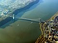 Aerial view showing situation atop Palisades Sill
 View of New York City and New Jersey from south walkway
