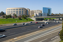
East Palo Alto, California
city in San Mateo County, California, United States From Wikipedia, the free encyclopedia
city in San Mateo County, California, United States From Wikipedia, the free encyclopedia
East Palo Alto is a city in San Mateo County, California. It shares borders with Menlo Park and Palo Alto.
East Palo Alto, California | |
|---|---|
 University Circle at University Avenue and U.S. Route 101 | |
| Nickname: E.P.A. | |
 Location of East Palo Alto in San Mateo County, California. | |
| Coordinates: 37°28′1″N 122°8′23″W | |
| Country | United States |
| State | California |
| County | San Mateo |
| Incorporated | July 1, 1983[1] |
| Named for | El Palo Alto |
| Area | |
| • Total | 2.64 sq mi (6.85 km2) |
| • Land | 2.53 sq mi (6.55 km2) |
| • Water | 0.12 sq mi (0.30 km2) |
| Elevation | 20 ft (6 m) |
| Population | |
| • Total | 30,034 |
| • Density | 11,000/sq mi (4,400/km2) |
| Time zone | UTC-8 (PST) |
| • Summer (DST) | UTC-7 (PDT) |
| ZIP code | 94303 |
| Area code | 650 |
| FIPS code | 06-20956 |
| GNIS feature ID | 1658461 |
| Website | www |
Seamless Wikipedia browsing. On steroids.
Every time you click a link to Wikipedia, Wiktionary or Wikiquote in your browser's search results, it will show the modern Wikiwand interface.
Wikiwand extension is a five stars, simple, with minimum permission required to keep your browsing private, safe and transparent.