Azad Kashmir
region administered by Pakistan From Wikipedia, the free encyclopedia
Remove ads
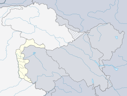
Azad Jammu and Kashmir, (Urdu: آزاد جموں و کشمیر پاکستان) also just called Azad Kashmir is a self-governing region that falls under Pakistan and is disputed region with India. In terms of land area it is bigger than Trinidad and Tobago but smaller than Brunei.
Remove ads
Geographically, to the north, is the Gilgit-Baltistan province, while to the south borders the province of Pakistani Punjabi, and to the east being the Indian-administered Kashmir.
The capital city of Azad Kashmir is Muzaffarabad. Azad Jammu and Kashmir has an area of 5,134 mi² (13,297 km²). The inhabitants of this region are Kashmiri citizens of ethnic Pahari origin. About 4 million people live there.
Remove ads
Government and politics
Azad Kashmir is a self-governing state under Pakistan.[4][5] It has its own elected president, prime minister, legislature, high court, emblem and official flag. However, the highest body in the state is the Azad Jammu and Kashmir Council. This council has six members from the government of Azad Kashmir (including the President and the Prime Minister of Azad Kashmir) and five members from the government of Pakistan, including the President of Pakistan who is the chairman/chief executive of the council.[4][5] Azad Kashmir is administratively divided into three divisions which, in turn, are divided into ten districts.
The Government of Azad Kashmir and Jammu is based in Muzaffarabad, the interim state capital of the Azad Kashmir disputed territory.
Remove ads
Divisions
The state is divided into three divisions.[6] The divisions are further divided into districts. There are 10 districts.
Remove ads
Geography
The northern part of Azad Jammu and Kashmir encompasses the lower area of the Himalayas, including Jamgarh Peak (4,734 m or 15,531 ft). However, Hari Parbat peak in Neelum Valley is the highest peak in the state. Fertile, green, mountainous valleys are characteristic of Azad Kashmir's geography, making it one of the most beautiful regions of the subcontinent.[4]
The region receives rainfall in both the winter and the summer. Muzaffarabad and Pattan are among the wettest areas of Pakistan. Throughout most of the region, the average rainfall exceeds 1400 mm, with the highest average rainfall occurring near Muzaffarabad (around 1800 mm). During the summer season, monsoon floods of the rivers Jhelum and Leepa are common due to extreme rains and snow melting.
References
Wikiwand - on
Seamless Wikipedia browsing. On steroids.
Remove ads


