Andhra Pradesh
state in South India, India From Wikipedia, the free encyclopedia
Remove ads
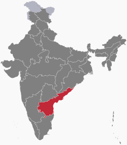
Andhra Pradesh (/ˌɑːndrə prəˈdɛʃ/) (![]() pronunciation (help·info)) is a state in the Republic of India. It has a population of 75,727,000 people according to the census of 2001. The eastern boundary is a 600 miles (970 km) coastline along the Bay of Bengal. Its latitude and longitude is 17.3660°N and 78.4760°E. The state has an area of 106,195 square miles (275,040 km2). It is bigger than Burkina Faso but smaller than Ecuador. In traditional Indian geography it falls under the South Indian zone. It was divided into Andhra Pradesh and Telangana in 2014, because of the Andhra Pradesh Reorganization Act 2014. According to this Act, both states will have the same capital city Hyderabad, for a period of 10 years.[6] The present Chief Minister of the state is Mr.Nara Chandrababu Naidu
pronunciation (help·info)) is a state in the Republic of India. It has a population of 75,727,000 people according to the census of 2001. The eastern boundary is a 600 miles (970 km) coastline along the Bay of Bengal. Its latitude and longitude is 17.3660°N and 78.4760°E. The state has an area of 106,195 square miles (275,040 km2). It is bigger than Burkina Faso but smaller than Ecuador. In traditional Indian geography it falls under the South Indian zone. It was divided into Andhra Pradesh and Telangana in 2014, because of the Andhra Pradesh Reorganization Act 2014. According to this Act, both states will have the same capital city Hyderabad, for a period of 10 years.[6] The present Chief Minister of the state is Mr.Nara Chandrababu Naidu
Remove ads
Andhra Pradesh has a gross domestic product (GDP) of 123,560 (in millions of US dollars). That makes it the third largest state in India in terms of GDP, after Maharashtra and Uttar Pradesh. Most of this money comes from agriculture. Andhra Pradesh is sometimes called the "Rice Bowl of India", as a very large amount of rice or paddy is grown in the coastal plains of the state. Recently the state is also involved in newer businesses like biotechnology and information technology.[7]
Remove ads
Provincial symbols of Andhra Pradesh
- Provincial bird of Andhra Pradesh
- Provincial animal of Andhra Pradesh
- Provincial tree of Andhra Pradesh
- Provincial flower of Andhra Pradesh
References
Wikiwand - on
Seamless Wikipedia browsing. On steroids.
Remove ads


