Alexander Island
island in the Bellingshausen Sea off Antarctica From Wikipedia, the free encyclopedia
Remove ads
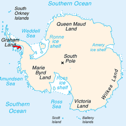
Alexander Island is also known as Alexander I Island, Alexander I Land, Alexander Land, lexander I Archipelago, and Zemlja Alexandra I. It is near the South Pole.


It is the largest island of Antarctica. It is in the Bellingshausen Sea west of Palmer Land. It is separated from Antarctic Peninsula by Marguerite Bay and George VI Sound. George VI Sound is filled with ice and connects Alexander Island to Palmer Land. The island partly surrounds Wilkins Sound, which is to its west.[1]
Alexander Island is about 240 miles (390 km) long. It is 50 miles (80 km) wide in the north and 150 miles (240 km) wide in the south.[2] Alexander Island is the second largest uninhabited island in the world, Devon Island is the largest.
Alexander Island was discovered on January 28, 1821. It was named for the reigning Tsar Alexander I of Russia. It was believed to be part of the Antarctic mainland until 1940.
A notable feature of Alexander Island is Hodgson Lake. It is a former subglacial lake that has come out from under an ice sheet that covered it. It is 2 km (1.2 mi) long by 1.5 km (0.93 mi). It has a 93.4 m (306 ft) deep water column that is sealed beneath 3.6 to 4.0 m (12 to 13 ft) thick lake ice.[3][4]
Remove ads
References
Wikiwand - on
Seamless Wikipedia browsing. On steroids.
Remove ads

