Willamette River
major river in northwest Oregon From Wikipedia, the free encyclopedia
major river in northwest Oregon From Wikipedia, the free encyclopedia
The Willamette River is a major tributary of the Columbia River, accounting for 12 to 15 percent of the Columbia's flow. The Willamette's main stem is 187 miles (301 km) long, lying entirely in northwestern Oregon in the United States. Flowing northward between the Oregon Coast Range and the Cascade Range, the river and its tributaries form the Willamette Valley, a basin that contains two-thirds of Oregon's population, including the state capital, Salem, and the state's largest city, Portland, which surrounds the Willamette's mouth at the Columbia.
This article includes a list of references or other websites, but its sources remain unclear because it does not have enough inline citations. (August 2017) |
| Willamette River | |
|---|---|
 The Willamette passing through Downtown Portland in the 1980s | |
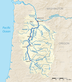
 A map of the Willamette River, its drainage basin, major tributaries and major cities | |
| Etymology | From a Clackamas Native American village name[1] |
| Location | |
| Country | United States |
| State | Oregon |
| Cities | Eugene, Corvallis, Albany, Independence, Salem, Newberg, Wilsonville, Portland |
| Physical characteristics | |
| Source | Confluence of Middle Fork Willamette River and Coast Fork Willamette River |
| - location | near Eugene, Lane County, Oregon |
| - coordinates | 44°01′23″N 123°01′25″W[2] |
| - elevation | 438 ft (134 m)[2] |
| Mouth | Columbia River |
| - location | Portland, Multnomah County, Oregon |
| - coordinates | 45°39′10″N 122°45′53″W[2] |
| - elevation | 10 ft (3.0 m)[2] |
| Length | 187 mi (301 km)[3] |
| Basin size | 11,478 sq mi (29,730 km2)[4] |
| Discharge | |
| - location | Morrison Bridge, Portland, 12.8 miles (20.6 km) from mouth |
| - average | 33,010 cu ft/s (935 m3/s) |
| - minimum | 4,200 cu ft/s (120 m3/s) |
| - maximum | 420,000 cu ft/s (12,000 m3/s) |
| Basin features | |
| Tributaries | |
| - left | Coast Fork Willamette River, Long Tom River, Marys River, Luckiamute River, Yamhill River, Tualatin River |
| - right | Middle Fork Willamette River, McKenzie River, Calapooia River, Santiam River, Molalla River, Clackamas River |
Originally created by plate tectonics about 35 million years ago and subsequently altered by volcanism and erosion, the river's drainage basin was significantly modified by the Missoula Floods at the end of the most recent ice age. Humans began living in the watershed over 10,000 years ago. There were once many tribal villages along the lower river and in the area around its mouth on the Columbia. Indigenous peoples lived throughout the upper reaches of the basin as well.
Seamless Wikipedia browsing. On steroids.
Every time you click a link to Wikipedia, Wiktionary or Wikiquote in your browser's search results, it will show the modern Wikiwand interface.
Wikiwand extension is a five stars, simple, with minimum permission required to keep your browsing private, safe and transparent.