county in Indiana, United States From Wikipedia, the free encyclopedia
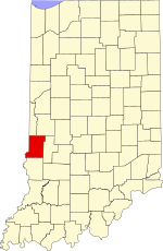
Vigo County (/ˈviːɡoʊ/ US dict: vē′·gō or /ˈvaɪɡoʊ/ US dict: vī′·gō) is a county along the western border of Indiana. As of the 2020 census, the population was 106,153.[1] The county seat is Terre Haute.[2]
Vigo County | |
|---|---|
 Vigo County Courthouse in Terre Haute | |
 Location within the U.S. state of Indiana | |
 Indiana's location within the U.S. | |
| Coordinates: 39°26′N 87°23′W | |
| Country | |
| State | |
| Founded | February 1, 1818 |
| Named for | Francis Vigo |
| Seat | Terre Haute |
| Largest city | Terre Haute |
| Area | |
| • Total | 410.45 sq mi (1,063.1 km2) |
| • Land | 403.31 sq mi (1,044.6 km2) |
| • Water | 7.14 sq mi (18.5 km2) 1.74% |
| Population | |
| • Total | 106,153 |
| • Density | 263.0/sq mi (101.5/km2) |
| Time zone | UTC−5 (Eastern) |
| • Summer (DST) | UTC−4 (EDT) |
| Congressional district | 8th |
| Website | www |
| Indiana county number 84 | |
Seamless Wikipedia browsing. On steroids.
Every time you click a link to Wikipedia, Wiktionary or Wikiquote in your browser's search results, it will show the modern Wikiwand interface.
Wikiwand extension is a five stars, simple, with minimum permission required to keep your browsing private, safe and transparent.